METAR & TAF KSPG
Current METAR
Observed 19:53Z
KSPG 271953Z 24006KT 10SM -RA FEW065 SCT095 BKN120 26/25 A2990 RMK AO2 LTG DSNT N RAB33 SLP124 P0000 T02610250
- Wind
- 240° @ 6 kt
- Visibility
- 10 SM
- Temp / Dew
- 26°C / 25°C
- Altimeter
- 29.90 inHg
- Clouds
- BKN
- Density alt
- 1,353 ft
- Ceiling
- 12,000 ft AGL
- Rules
- VFR
Airport info & contacts
Manager on record, flight service, ARTCC, attendance schedule and pattern altitude — published by the FAA and refreshed every 28 days.
Location
- From city
- 0 NM E
- VFR sectional
- MIAMI
- Pattern altitude
- 800 ft AGL · 807 ft MSL
- ARTCC
- ZMA · MIAMI
- NOTAM facility
- SPG (NOTAM-D)
Airport manager
- Name
- RICH LESNIAK
- Phone
- 727-893-7657
- Address
- ALBERT WHITTED AIRPORT, 107 8TH AVENUE SOUTHEAST, ST PETERSBURG FL 33701
Flight service · Hours
- FSS PIE
- SAINT PETERSBURG1-800-WX-BRIEF
- Attendance
- 0600-2100
Frequencies
Tap any row to copy the frequency to your clipboard.
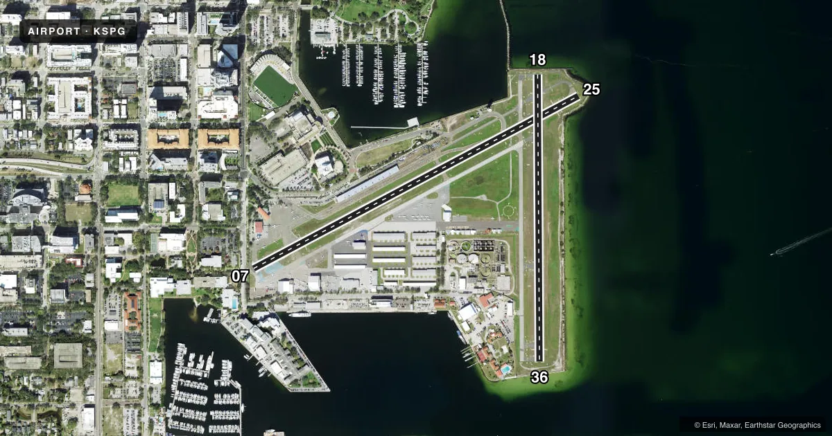
Runways & pattern
Full pagePattern entry · RWY 25
LEFT TRAFFIC| Runway | Heading (°M) | Length | Surface | Traffic |
|---|---|---|---|---|
| 07/25Favored | 57° / 237° | 3,676 ft | ASPH | 07 R |
| 18/36 | 175° / 355° | 2,864 ft | ASPH | 36 R |
Runway end performance
| End | TORA | TODA | ASDA | LDA | VGSI | Approach lights | Obstruction |
|---|---|---|---|---|---|---|---|
| 07 | 3,646' | 3,646' | 3,376' | 2,849' | PAPI 2-box left(3.31°) | — | 19', bldg, 201' from thr, 0' R of cntrln, slope 0 |
| 25 | 3,180' | 3,180' | 3,312' | 3,042' | PAPI 2-box left(3.9°) | — | 52', boat, 1020' from thr, 0' R of cntrln, slope 15 |
| 18 | 2,864' | 2,864' | 2,749' | 2,559' | PAPI 2-box right(4°) | — | 40', boat, 1000' from thr, 0' R of cntrln, slope 20 |
| 36 | 2,864' | 2,864' | 2,674' | 2,559' | PAPI 2-box left(4°) | — | 37', boat, 614' from thr, 0' R of cntrln, slope 11 |
Declared distances in feet. TORA = takeoff run available, TODA = takeoff distance, ASDA = accelerate-stop, LDA = landing distance.
Airport sketch
Runways drawn to scale from FAA survey coordinates, rendered over satellite imagery. Not for navigation.
Approaches & charts
Services on the field
Fuel grades, oxygen, maintenance, ramp storage and lighting — as declared to the FAA by the airport operator.
Fuel & services
- Fuel
- 100LLAA1
- Oxygen (bottled)
- Low pressure
- Oxygen (bulk)
- Not available
- Airframe repair
- Major
- Power plant repair
- Major
- Other services
- AMB,AVNCS,CHTR,INSTR,RNTL,SALES,SURV
Ramp & ground
- Transient storage
- Tie-down
- Hangar
- Landing fee
- No fee published
- Customs
- Not available
- Lighting schedule
- SEE RMK
- Beacon schedule
- SS-SR
- Beacon
- White / Green (civil land)(WG)
- Wind indicator
- Lighted
- Segmented circle
- Yes
Fuel & FBOs
Cheapest 100LL and Jet A on the field and nearby. Always confirm with the FBO before taxi.
Airport notes
Surface conditions, obstructions, local procedures, lighting outages and other notes published with each FAA cycle.
General notes
- BANNER TOWING E OF RWY 18/36.
- BIRDS ON & INVOF ARPT; GULLS ON RWY DURG INCLEMENT WX.
- OCEAN VESSELS IN SHIP CHANNELS.
- ALERT - HEAVY JET ACFT INVOF ARPT 1600 FT & ABV.
- +/- 100 FT LIT/UNLIT BOAT MASTS IN RWY 18, 25 & 36 APCH AREA.
- EMERG HELI WITH ROTG BCN 1/2 MI W OF ARPT.
- WHEN ATCT CLSD; FOR CD CTC TAMPA APCH - 813-878-2528.
Lighting notes
- ACTVT MIRL RWY 18/36 & RWY 07/25 - CTAF, REIL RWYS 7, 25, & 36 ACTVT WHEN MIRL ACTVT, REIL RWY 18 ONLY ACTVT ON STEP 3 MIRL, PAPI RWYS 07, 25, 18 & 36 OPERATE CONTINUOUSLY.
Approach & departure obstructions
- 0719 FT BLAST FENCE AT RWY END, 15 FT STREET 5 FT FM RWY END, 24 FT BLDG 100 FT FM RWY END.
- 25TGL NA.
- 36SHIP CHANNEL & OCEAN VESSELS IN APCH AREA.
- 07CONTROLLING OBSTN EXCEEDS A 45 DEG SLP. BLAST FENCE 6 FT BFR AER. RWY 07 APCH RATIOS 20:1 FM DTHR.
- 18RWY 18 APRCH SLP 29:1 TO DTHR.
- 25RWY 25 APCH RATIO 25:1 FM DTHR.
VFR map & nearby airports
VFR sectional. Tap any ICAO chip to open that airport.
Key facts · KSPG
Answer card- ICAO
- KSPG
- Name
- ALBERT WHITTED
- Location
- ST PETERSBURG, FLORIDA
- Elevation
- 6.6 ft MSL
- Traffic pattern altitude
- 806.6 ft MSL (800 AGL)
- Control tower
- Towered · 0700-2100
- Total runways
- 2
- Longest runway
- 07/25 · 3,676 ft
- Published ILS approaches
- 0
- Published frequencies
- 8
- Magnetic variation
- 5°
- Current flight rules
- VFR
- Current wind
- 240° at 6 kt
- Favored runway now
- RWY 25
Albert Whitted Airport (KSPG) sits in St Petersburg, Florida. Field elevation is 6.6 ft MSL. The airport has two asphalt runways. The longest is runway 07/25 at 3,676 ft. The tower is open 0700-2100. When the tower is closed, clearance delivery is handled by Tampa Approach at 813-878-2528.
No ILS approaches are published here. Pattern altitude is 800 ft AGL, which is 806.6 ft MSL. Sheltair is on the field. It carries 100LL, Jet A and Jet A Prist. That makes fuel planning simple for piston and turbine traffic.
This is a low-elevation coastal airport with a busy mix of local traffic and heavier aircraft in the area. Published remarks call out boat masts in the approach areas for runways 18, 25 and 36. There are also ship channels and ocean vessels near the field. Banner towing occurs east of runway 18/36. Runway 07 has several close-in obstacles. Runway 25 does not allow touch and go landings. Runway lighting is pilot-controlled via CTAF. If you are new to KSPG, brief the obstacle picture before arrival. Expect a busy environment near the shoreline.