METAR & TAF KSLN
Current METAR
Observed 19:53Z
KSLN 271953Z 20018KT 10SM CLR 42/17 A2977 RMK AO2 PK WND 20028/1924 SLP059 T04220167
- Wind
- 200° @ 18 kt
- Visibility
- 10 SM
- Temp / Dew
- 42°C / 17°C
- Altimeter
- 29.77 inHg
- Clouds
- CLR
- Density alt
- 5,023 ft
- Ceiling
- Unlimited
- Rules
- VFR
Airport info & contacts
Manager on record, flight service, ARTCC, attendance schedule and pattern altitude — published by the FAA and refreshed every 28 days.
Location
- From city
- 3 NM SW
- VFR sectional
- WICHITA
- ARTCC
- ZKC · KANSAS CITY
- NOTAM facility
- SLN (NOTAM-D)
Airport manager
- Name
- MR. PIETER MILLER
- Phone
- 785-827-3914
- Address
- 3237 ARNOLD AVENUE, SALINA KS 67401
Flight service · Hours
- FSS ICT
- WICHITA1-800-WX-BRIEF
- Attendance
- ALL
Frequencies
Tap any row to copy the frequency to your clipboard.
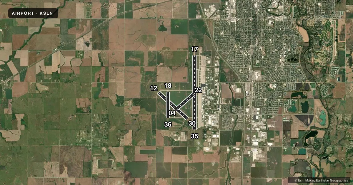
Runways & pattern
Full pagePattern entry · RWY 17
LEFT TRAFFIC| Runway | Heading (°M) | Length | Surface | Traffic |
|---|---|---|---|---|
| 17/35Favored | 173° / 353° | 12,301 ft | ASPH-CONC | Standard L |
| 12/30 | 125° / 305° | 6,510 ft | ASPH | Standard L |
| 18/36 | 173° / 353° | 4,301 ft | ASPH | Standard L |
| 04/22 | 42° / 222° | 3,648 ft | ASPH | Standard L |
Runway end performance
| End | TORA | TODA | ASDA | LDA | VGSI | Approach lights | Obstruction |
|---|---|---|---|---|---|---|---|
| 17 | 12,300' | 12,300' | 12,300' | 12,300' | PAPI 4-box left(3°) | MALS | — |
| 35 | 12,300' | 12,300' | 12,300' | 12,300' | PAPI 4-box right(3°) | MALSR | 30', gnd, 1375' from thr, 500' R of cntrln, slope 39 |
| 12 | 6,510' | 6,510' | 6,510' | 6,510' | PAPI 4-box left(3°) | — | — |
| 30 | 6,510' | 6,510' | 6,510' | 6,510' | PAPI 4-box left(3°) | — | — |
| 18 | 4,300' | 4,300' | 4,300' | 4,300' | — | — | — |
| 36 | 4,300' | 4,300' | 4,300' | 4,300' | — | — | — |
| 04 | 3,648' | 3,648' | 3,648' | 3,648' | — | — | — |
| 22 | 3,648' | 3,648' | 3,648' | 3,648' | — | — | 46', bldg, 1550' from thr, 200' R of cntrln, slope 29 |
Declared distances in feet. TORA = takeoff run available, TODA = takeoff distance, ASDA = accelerate-stop, LDA = landing distance.
Airport sketch
Runways drawn to scale from FAA survey coordinates, rendered over satellite imagery. Not for navigation.
Approaches & charts
ILS · 1
Services on the field
Fuel grades, oxygen, maintenance, ramp storage and lighting — as declared to the FAA by the airport operator.
Fuel & services
- Fuel
- 100LLA
- Oxygen (bottled)
- Not available
- Oxygen (bulk)
- High pressure
- Airframe repair
- Major
- Power plant repair
- Major
- Other services
- AMB,CARGO,CHTR,INSTR,RNTL,SALES
Ramp & ground
- Transient storage
- Tie-down
- Hangar
- Landing fee
- No fee published
- Customs
- Not available
- Lighting schedule
- SEE RMK
- Beacon schedule
- SS-SR
- Beacon
- White / Green (civil land)(WG)
- Wind indicator
- Yes
- Segmented circle
- No
Fuel & FBOs
Cheapest 100LL and Jet A on the field and nearby. Always confirm with the FBO before taxi.
Airport notes
Surface conditions, obstructions, local procedures, lighting outages and other notes published with each FAA cycle.
General notes
- NO LINE OF SIGHT, ALL RYS DUE TO GRADIENT, TOPOGRAPHY & TREES.
- SEASONAL MOWING OPNS ADJ TO RYS & TWYS.
- CALM WND RY 35.
- ARNG: OPR 1300-2300Z++ TUE-FRI; OCNL SAT EXC HOL. LTD MAINT UH-60. ARNG, AR AND A CTC ARNG OPS PRIOR TO LDG OR CALL 785-646-3430 FOR OPERATIONS.
- SVC: JASU- 2(A/M32-95) 2(A/M32-60B) 1(A/M32-86D).
- SVC: FLUID- LPOX, HPOX, LPNIT, LOX (72HR NOTICE) DEICING SERVICE TYPE 1& TYPE 4 OIL 0-128-148 AVBL IN QUART CANS TRANS SVC AVBL AT FBO. LOGISTICAL SVC AVBL FOR DETS AND RON AT FBO (AVFLIGHT SALINA, 785-825-6739/CELL 785-819-2236.)
- ARNG: RAMP SPACE AVBL TO ACCOMMODATE UP TO 80 FIGHTERS. SMOKY HILL ANG WEAPONS RANGE 16 NM TO THE SOUTHWEST. COORD RANGE TIME AT DSN 743-7600 EXT 148 OR 785-646-3318. MILITARY BILLETING AVAILABLE 888-577-8257. LOGISTIC EQPT AVBL FOR USE. ORDNANCE STORAGE FOR CLASS 1.3 THRU 1.4.
- ARNG: TRAN ARMY ACFT CTC SALINA GUARD OPS ON 229.2 OR 40.525 SC RED. LIMITED UH-60 SVC AND MAINT AVBL.
- 100LL SELF SVC FUELING STN LOCATED SOUTH OF KANSAS ANG.
- GND SUPPORT AND LOGISTICS EQUIP AVBL INCL TUGS, BOBTAILS, TOW BARS AND AIRSTAIRS.
- H1 INGRESS/EGRESS 070 DEG THROUGH 040 DEG TO AVOID CTL TWR.
- ALL HELIPADS DALGT USE ONLY.
- H3, H4, H5, H6 USED EXTSVLY FOR TRNG.
- H2, H3 LTD TO 6,000 LBS; H4, H5 LTD TO 25,000 LBS.
- NOISE ABATEMENT: HEAVY & MIL ACFT TPA AT 2,800 MSL OR ABOVE.
- FOR CD IF UNA TO CTC ON FSS FREQ, CTC KANSAS CITY ARTCC AT 913-254-8508.
- BTN 0001-0459L ACR OPNS INVOLVING ACFT WITH MORE THAN 9 PSGRS SEATS ARE NOT AUTH IN EXCESS OF 15 MINS BFR OR AFT SKED ARR OR DEP TIMES WO PRIOR COORD WITH AMGR TO CFM THAT ARFF SVCS ARE AVBL PRIOR TO LNDG OR TKOF. CALL AMGR 785-827-3914.
Lighting notes
- WHEN ATCT CLSD ACTVT MIRL RY 12/30; PAPI RYS 12 & 30; HIRL RY 17/35; MALS & PAPI RYS 17 & 35; MALSR RY 35 - CTAF.
Runway surface & condition
- 12/30PCR VALUE: 176/F/D/X/T
- 17/35PCR VALUE: 840/F/D/X/T
- 04/22RWY 04/22 NOT AVBL FOR PART 121/PART 380 OPS WITH SKED PAX CARRYING OPS MORE THAN 9 PAX SEATS AND NON-SKED PAX CARRYING OPS MORE THAN 30 PAX SEATS.
- 18/36RWY 18/36 NOT AVBL FOR PART 121/PART 380 OPS WITH SKED PAX CARRYING OPS MORE THAN 9 PAX SEATS AND NON-SKED PAX CARRYING OPS MORE THAN 30 PAX SEATS.
Other notes
- PPR 24 HRS FOR UNSKED ACR OPNS WITH MORE THAN 30 PSGR SEATS CALL AMGR 785-827-3914. ARFF INDEX B PROVDD SUN-SAT 0600 TO 2200 (LOCAL). INDEX E AVBL UPON REQ.
VFR map & nearby airports
VFR sectional. Tap any ICAO chip to open that airport.
Key facts · KSLN
Answer card- ICAO
- KSLN
- Name
- SALINA RGNL
- Location
- SALINA, KANSAS
- Elevation
- 1,288 ft MSL
- Traffic pattern altitude
- 2,288 ft MSL (1,000 AGL)
- Control tower
- Towered · 0700-2300
- Total runways
- 4
- Longest runway
- 17/35 · 12,301 ft
- Published ILS approaches
- 1
- Published frequencies
- 9
- Magnetic variation
- 7°
- Current flight rules
- VFR
- Current wind
- 200° at 18 kt
- Favored runway now
- RWY 17
Salina Regional Airport sits in Salina, Kansas. Field elevation is 1,288 ft MSL. The airport has four runways. The longest is 12,301 ft on 17/35. Tower service is published from 0700 to 2300 local. One ILS approach is available to runway 35. Pattern altitude is not published. Use the standard 1,000 ft AGL for light piston traffic unless the current Chart Supplement says otherwise.
Avflight Salina is on the field. It carries 100LL, Jet A and Jet A Prist. That makes the field useful for piston, turboprop and jet traffic. Runway 12/30 is 6,510 ft. Runway 04/22 is 3,648 ft. Runway 18/36 is 4,301 ft. Runway 17/35 is the main long runway and it is asphalt-concrete.
A few remarks matter for planning. When the tower is closed, use CTAF and the published lighting procedures for the active runway. Seasonal mowing happens near runways and taxiways. There are also special operating limits for some large passenger aircraft. Prior permission is required for unscheduled operations over 30 passenger seats. If you are flying something large, check the current Chart Supplement and call the airport manager before departure. The field also has military activity nearby. Expect a busy environment at times.