METAR & TAF KSLE
Current METAR
Observed 10:56Z
KSLE 271056Z AUTO 18005KT CLR 11/09 A3008 RMK AO2 SLP184 T01110094 $
- Wind
- 180° @ 5 kt
- Visibility
- —
- Temp / Dew
- 11°C / 9°C
- Altimeter
- 30.08 inHg
- Clouds
- CLR
- Density alt
- -414 ft
- Ceiling
- Unlimited
- Rules
- VFR
Airport info & contacts
Manager on record, flight service, ARTCC, attendance schedule and pattern altitude — published by the FAA and refreshed every 28 days.
Location
- From city
- 2 NM SE
- VFR sectional
- SEATTLE
- ARTCC
- ZSE · SEATTLE
- NOTAM facility
- SLE (NOTAM-D)
Airport manager
- Name
- AARON ISON
- Phone
- 503-589-2057
- Address
- 2990 25TH ST SE, SALEM OR 97302
Flight service · Hours
- FSS MMV
- MC MINNVILLE1-800-WX-BRIEF
- Attendance
- MON-FRI · 0700-1900
- SAT-SUN · 0700-1700
Frequencies
Tap any row to copy the frequency to your clipboard.
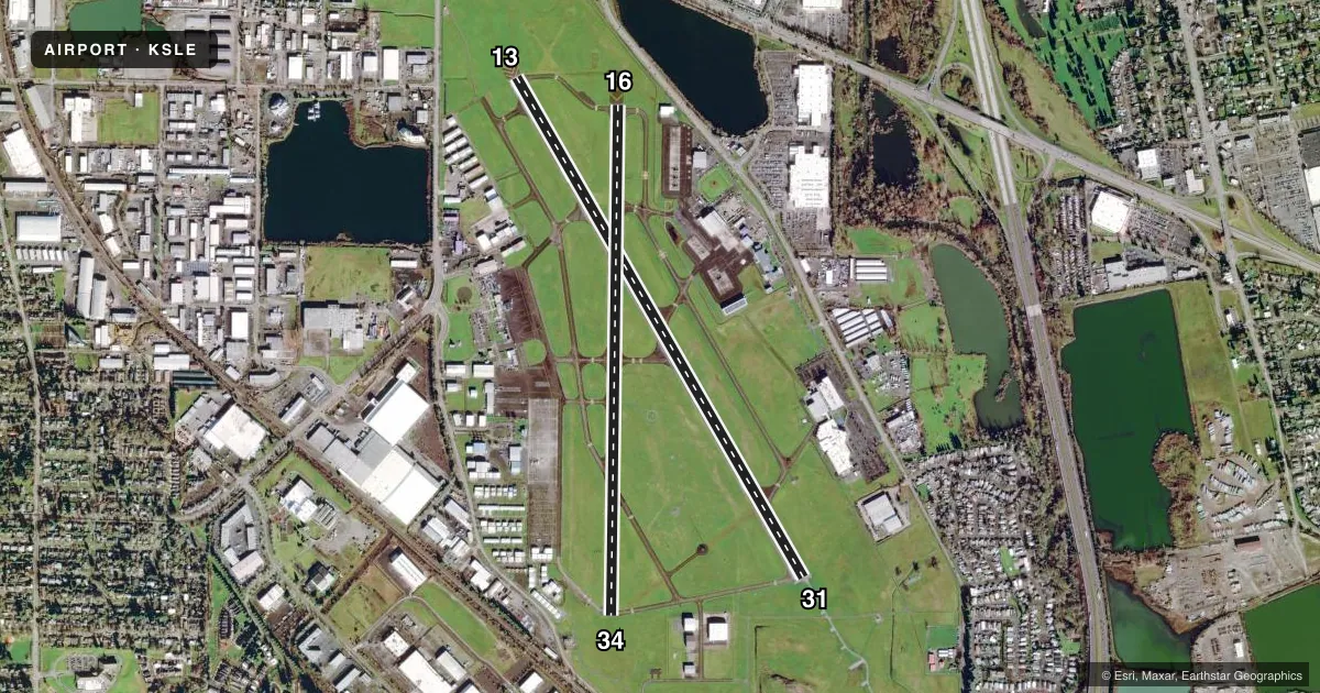
Runways & pattern
Full pagePattern entry · RWY 16
LEFT TRAFFIC| Runway | Heading (°M) | Length | Surface | Traffic |
|---|---|---|---|---|
| 13/31 | 133° / 313° | 5,811 ft | ASPH | Standard L |
| 16/34Favored | 164° / 344° | 5,146 ft | ASPH | Standard L |
Runway end performance
| End | TORA | TODA | ASDA | LDA | VGSI | Approach lights | Obstruction |
|---|---|---|---|---|---|---|---|
| 13 | 5,811' | 5,811' | 5,811' | 5,811' | VASI 4-box left(3°) | ODALS | 11', road, 600' from thr, 550' R of cntrln, slope 36 |
| 31 | 5,811' | 5,811' | 5,811' | 5,811' | — | MALSR | 459', tree, 15950' from thr, 1900' R of cntrln, slope 30 |
| 16 | 5,145' | 5,145' | 5,145' | 5,145' | PAPI 4-box left(3°) | — | 16', road, 430' from thr, 280' R of cntrln, slope 14 |
| 34 | 5,145' | 5,145' | 5,145' | 5,145' | PAPI 4-box left(4°) | — | 216', tree, 4528' from thr, 273' R of cntrln, slope 20 |
Declared distances in feet. TORA = takeoff run available, TODA = takeoff distance, ASDA = accelerate-stop, LDA = landing distance.
Airport sketch
Runways drawn to scale from FAA survey coordinates, rendered over satellite imagery. Not for navigation.
Approaches & charts
ILS · 1
Services on the field
Fuel grades, oxygen, maintenance, ramp storage and lighting — as declared to the FAA by the airport operator.
Fuel & services
- Fuel
- 100LLA
- Oxygen (bottled)
- High pressure
- Oxygen (bulk)
- High pressure
- Airframe repair
- Major
- Power plant repair
- Major
- Other services
- AFRT,AMB,AVNCS,CHTR,INSTR,RNTL,SALES
Ramp & ground
- Transient storage
- Tie-down
- Hangar
- Landing fee
- Yes
- Customs
- Not available
- Lighting schedule
- SEE RMK
- Beacon schedule
- SS-SR
- Beacon
- White / Green (civil land)(WG)
- Wind indicator
- Lighted
- Segmented circle
- Yes
Fuel & FBOs
Cheapest 100LL and Jet A on the field and nearby. Always confirm with the FBO before taxi.
Airport notes
Surface conditions, obstructions, local procedures, lighting outages and other notes published with each FAA cycle.
General notes
- BIRD HAZ: WATERFOWL INVOF ARPT; GEESE TRSN CLASS D TPA OCT-MAY.
- TWY A FM TWY L TO L9 NOT VSB FM ATCT.
- NOISE ABATMENT PROC IN EFCT; AVOID OTFC RESIDENTIAL AREAS.
- RISING TRRN & TREES W & S OF ARPT & RWY 34 EXTDD CNTRLN. TREES ON RWY 16 EXTDD CNTRLN. NGT OPS NOT RCMD BOTH RWYS.
- ARNG: 1500-0030Z++ MON-FRI EXC HOL. TSNT PPR - D355-1401/ C971-355-1401; TSNT ALERT SVC & PRKG NA. ROTARY WING NOISE ABATEMENT PROC IN EFCT. TSNT ROTARY WING USE SANTIAM ARR/DEP. ARNG LGT ACFT PAX SVC VIP PAD S END OF MIL RAMP. DURG DUTY HR CTC GUARD OPS 10 MIN OUT - 40.90, 142.8, 248.5. OSA OPS - D355-1409/C971-355-1409.
- FOR CD IF UNA TO CTC ON FSS FREQ, CTC SEATTLE ARTCC AT 253-351-3694.
- CLSD AFT HVY SNOW. ARPT COND UNMNT 1600L-0800L & WKEND.
- ACR OPS USE TWY A, TWY A1, TWY A2, TWY B, TWY C FM TWY A TO J, TWY F FM TWY A TO RWY 31, TWY J.
Lighting notes
- WHEN ATCT CLSD ACTVT MALSR RWY 31; ODAL RWY 13; REIL RWY 13, 16, 34; HIRL RWY 13/31; MIRL RWY 16/34 - CTAF. REIL RWY 16, PAPI RWY 16 & 34 OTS INDEFLY.
Fuel notes
- 100LL100 LL SELF SVC H24.
- AAFT HR JET A PPR - 503-508-4178 OR 503-364-4158.
Runway surface & condition
- 13/31PCR VALUE: 510/F/C/X/T
Other notes
- ESTBD PRIOR TO 1959.
- PPR FOR UNSKED ACR OPS GTR THAN 30 PAX SEATS - AMGR.
- LDG FEE FOR COML & ITNRNTT WITH FAA CERTIFIED MAX GROSS LDG WT GTR THAN 7000 LB.
- OVNGT TIEDOWN & COML AIR CHARTER LDG FEE. HGR AVBL PPR - 503-364-4158 OR 503-585-3838.
VFR map & nearby airports
VFR sectional. Tap any ICAO chip to open that airport.
Key facts · KSLE
Answer card- ICAO
- KSLE
- Name
- MCNARY FLD
- Location
- SALEM, OREGON
- Elevation
- 213.4 ft MSL
- Traffic pattern altitude
- 1,213.4 ft MSL (1,000 AGL)
- Control tower
- Towered · 0700-2100
- Total runways
- 2
- Longest runway
- 13/31 · 5,811 ft
- Published ILS approaches
- 1
- Published frequencies
- 8
- Magnetic variation
- 17°
- Current flight rules
- VFR
- Current wind
- 180° at 5 kt
- Favored runway now
- RWY 16
McNary Field is in Salem, Oregon. The field elevation is 213.4 ft MSL. It has two asphalt runways. The longest is 5,811 ft on runway 13/31. The tower is open 0700-2100. One ILS is published for runway 31.
Pattern altitude is not published. Use 1,000 ft AGL for light piston traffic unless ATC or the current Chart Supplement says otherwise. Salem Aviation Fueling is on the field. It carries 100LL, Jet A and Jet A Prist. Noise abatement is active here. Avoid overflight of residential areas. Rotary wing traffic has its own procedures. Bird activity is also a factor, with waterfowl in the area. Trees and rising terrain sit west and south of the airport. Trees are also on the extended centerline for runway 16. Night operations are not recommended on both runways.
If you are arriving in a piston airplane, plan ahead for the tower hours and the published lighting setup when the tower is closed. Runway 31 has MALSR. Runway 13 has omnidirectional approach lighting. Runway end identifier lights are out of service on runway 16. The precision approach path indicators for runways 16 and 34 are out of service indefinitely. Check the current Chart Supplement before you go if you need the latest operating notes.