METAR & TAF KROW
Current METAR
Observed 21:51Z
KROW 272151Z 14011G19KT 10SM CLR 41/12 A2990 RMK AO2 SLP042 T04060117 $
- Wind
- 140° @ 11G19 kt
- Visibility
- 10 SM
- Temp / Dew
- 41°C / 12°C
- Altimeter
- 29.90 inHg
- Clouds
- CLR
- Density alt
- 7,697 ft
- Ceiling
- Unlimited
- Rules
- VFR
Airport info & contacts
Manager on record, flight service, ARTCC, attendance schedule and pattern altitude — published by the FAA and refreshed every 28 days.
Location
- From city
- 3 NM S
- VFR sectional
- ALBUQUERQUE
- ARTCC
- ZAB · ALBUQUERQUE
- NOTAM facility
- ROW (NOTAM-D)
Airport manager
- Name
- OMAR GONZALEZ
- Phone
- 239-980-5114
- Address
- 1 JERRY SMITH CIR, ROSWELL NM 88203-8427
Flight service · Hours
- FSS ABQ
- ALBUQUERQUE1-800-WX-BRIEF
- Attendance
- 0600-2100
Frequencies
Tap any row to copy the frequency to your clipboard.
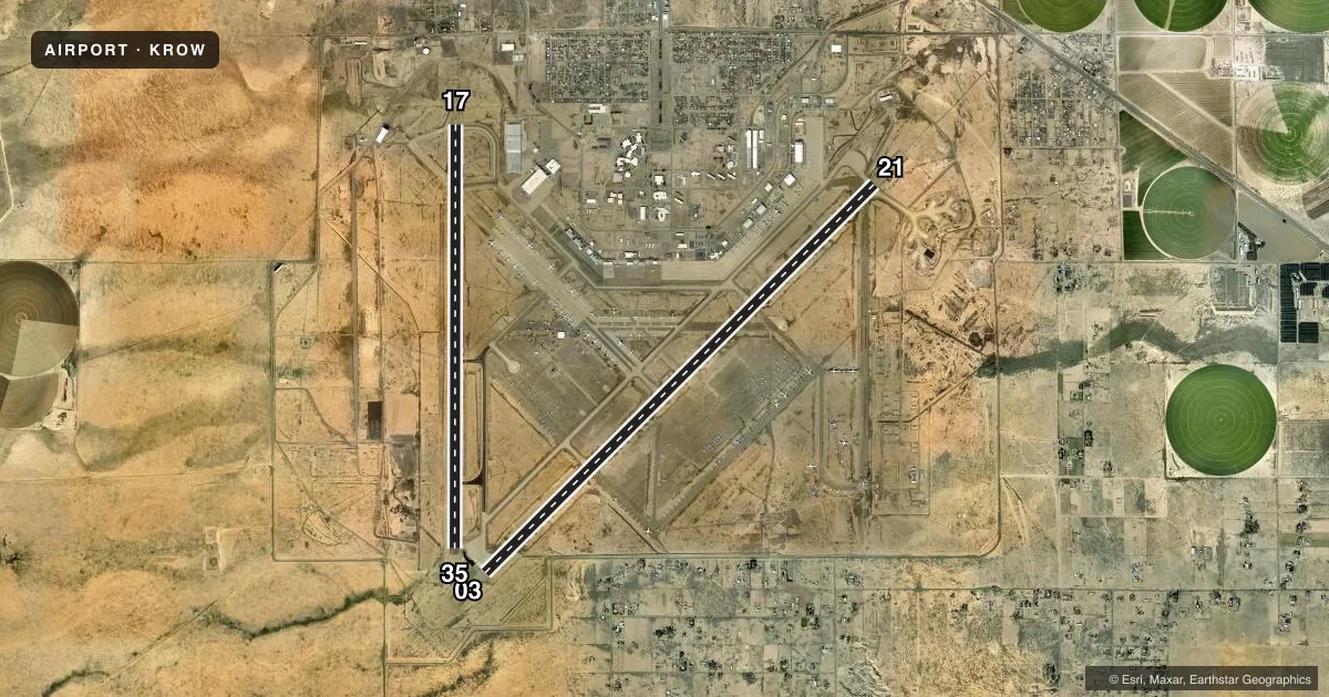
Runways & pattern
Full pagePattern entry · RWY 17
RIGHT TRAFFIC| Runway | Heading (°M) | Length | Surface | Traffic |
|---|---|---|---|---|
| 03/21 | 35° / 215° | 13,000 ft | CONC | 03 R |
| 17/35Favored | 170° / 350° | 10,008 ft | ASPH | 17 R |
Runway end performance
| End | TORA | TODA | ASDA | LDA | VGSI | Approach lights | Obstruction |
|---|---|---|---|---|---|---|---|
| 03 | 13,000' | 13,000' | 13,000' | 13,000' | VASI 6-box left(3°) | — | — |
| 21 | 13,000' | 13,000' | 13,000' | 13,000' | — | MALSR | — |
| 17 | 10,008' | 10,008' | 10,008' | 10,008' | PAPI 4-box left(3°) | — | — |
| 35 | 10,008' | 10,008' | 10,008' | 10,008' | PAPI 4-box left(3°) | — | — |
Declared distances in feet. TORA = takeoff run available, TODA = takeoff distance, ASDA = accelerate-stop, LDA = landing distance.
Airport sketch
Runways drawn to scale from FAA survey coordinates, rendered over satellite imagery. Not for navigation.
Approaches & charts
ILS · 1
Services on the field
Fuel grades, oxygen, maintenance, ramp storage and lighting — as declared to the FAA by the airport operator.
Fuel & services
- Fuel
- 100LLAA1+
- Oxygen (bulk)
- Low pressure
- Airframe repair
- Minor
- Power plant repair
- Minor
- Other services
- AFRT,AMB,INSTR
Ramp & ground
- Transient storage
- Tie-down
- Hangar
- Landing fee
- No fee published
- Customs
- Not available
- Lighting schedule
- SEE RMK
- Beacon schedule
- SS-SR
- Beacon
- White / Green (civil land)(WG)
- Wind indicator
- Lighted
- Segmented circle
- Yes
Fuel & FBOs
Cheapest 100LL and Jet A on the field and nearby. Always confirm with the FBO before taxi.
Airport notes
Surface conditions, obstructions, local procedures, lighting outages and other notes published with each FAA cycle.
General notes
- AFT HR EXIT RAMP/FBO AREA USE LGTD PEDESTRIAN GATE - 575-347-2054.
- BIRDS ON & INVOF ARPT.
- LRG ACFT LONG TERM STORAGE AVBL.
- FOR CD IF UNA TO CTC ON FSS FREQ, CTC ALBUQUERQUE ARTCC AT 505-856-4561.
Lighting notes
- ACTVT MALSR RWY 21; MIRL RWY 17/35 - CTAF. VASI RWY 03; PAPI RWY 17 & 35 - ON CONSLY. WHEN ATCT CLSD MIRL RWY 03/21 ON MED INTST.
Fuel notes
- 100LLAFT HR - 575-347-2054.
Runway surface & condition
- 03/21PCR VALUE: 1140/R/C/W/T
- 17/35PCR VALUE: 150/R/C/W/T
- 03/21NSTD 75 FT FM RWY EDGE.
Approach & departure obstructions
- 17PAPI UNUSBL BYD 8 DEG RIGHT OF CNTRLN.
Other notes
- 1AFT HR - 575-347-2054 OR 575-626-3697.
VFR map & nearby airports
VFR sectional. Tap any ICAO chip to open that airport.
Key facts · KROW
Answer card- ICAO
- KROW
- Name
- ROSWELL AIR CENTER
- Location
- ROSWELL, NEW MEXICO
- Elevation
- 3,671 ft MSL
- Traffic pattern altitude
- 4,671 ft MSL (1,000 AGL)
- Control tower
- Towered · 0600-2100
- Total runways
- 2
- Longest runway
- 03/21 · 13,000 ft
- Published ILS approaches
- 1
- Published frequencies
- 16
- Magnetic variation
- 10°
- Current flight rules
- VFR
- Current wind
- 140° at 11 kt
- Favored runway now
- RWY 17
Roswell Air Center is in Roswell, New Mexico. Field elevation is 3,671 ft MSL. The airport has two runways. The longest is runway 03/21 at 13,000 ft. The tower is open daily from 0600 to 2100. An ILS is available on runway 21, which is the runway to plan for if you need precision guidance.
Pattern altitude is not published for this field. Use the standard 1,000 ft AGL for light piston traffic unless ATC or the current Chart Supplement says otherwise. That puts the common pattern reference at 4,671 ft MSL. Avflight Roswell is on the field. It carries 100LL, Jet A and Jet A Prist. After hours, use the lighted pedestrian gate to exit the ramp and FBO area. Call the posted number before you go if you need access or 100LL after hours.
The field sits in controlled airspace with a busy towered environment. Expect to work the tower during published hours. Runway lighting is mixed, so pay attention to which lights are tower-controlled. Other lights are tied to CTAF. Birds are reported on and near the airport, so keep that in mind on departure and arrival. If you need clearance delivery and cannot reach flight service, contact Albuquerque ARTCC using the number in the Chart Supplement.