METAR & TAF KROA
Current METAR
Observed 12:54Z
KROA 271254Z 00000KT 10SM CLR 24/19 A2995 RMK AO2 SLP128 T02390189 $
- Wind
- 000° @ 0 kt
- Visibility
- 10 SM
- Temp / Dew
- 24°C / 19°C
- Altimeter
- 29.95 inHg
- Clouds
- CLR
- Density alt
- 2,500 ft
- Ceiling
- Unlimited
- Rules
- VFR
Airport info & contacts
Manager on record, flight service, ARTCC, attendance schedule and pattern altitude — published by the FAA and refreshed every 28 days.
Location
- From city
- 3 NM NW
- VFR sectional
- CINCINNATI
- Pattern altitude
- 800 ft AGL · 1,975 ft MSL
- ARTCC
- ZDC · WASHINGTON
- NOTAM facility
- ROA (NOTAM-D)
Airport manager
- Name
- MIKE STEWART
- Phone
- 540-362-1999
- Address
- 5202 AVN DR., ROANOKE VA 24012-1148
Flight service · Hours
- FSS DCA
- LEESBURG1-800-WX-BRIEF
- Attendance
- ALL
Frequencies
Tap any row to copy the frequency to your clipboard.
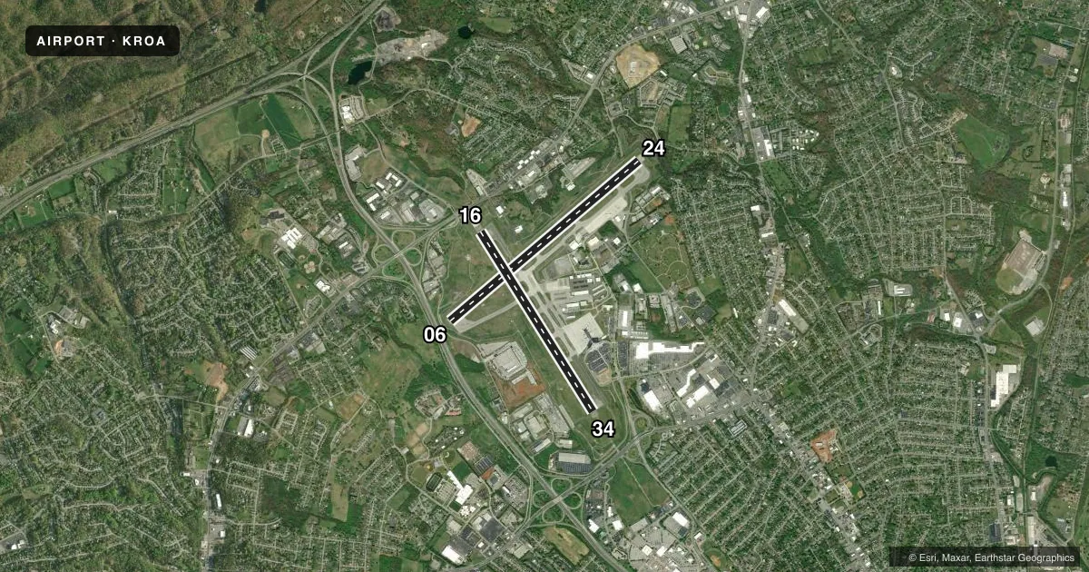
Runways & pattern
Full pagePattern entry · RWY 06
LEFT TRAFFIC| Runway | Heading (°M) | Length | Surface | Traffic |
|---|---|---|---|---|
| 06/24 | 42° / 222° | 6,800 ft | ASPH | Standard L |
| 16/34 | 140° / 320° | 5,810 ft | ASPH | Standard L |
Runway end performance
| End | TORA | TODA | ASDA | LDA | VGSI | Approach lights | Obstruction |
|---|---|---|---|---|---|---|---|
| 06 | 6,800' | 6,800' | 6,800' | 6,800' | VASI 4-box left(3°) | MALSR | — |
| 24 | 6,800' | 6,800' | 6,800' | 6,010' | PAPI 4-box left(3°) | — | — |
| 16 | 5,810' | 5,810' | 5,810' | 5,810' | — | — | — |
| 34 | 5,810' | 5,810' | 5,810' | 5,810' | PAPI 4-box left(3°) | MALSR | 837', tower, 26070' from thr, 0' R of cntrln, slope 30 |
Declared distances in feet. TORA = takeoff run available, TODA = takeoff distance, ASDA = accelerate-stop, LDA = landing distance.
Airport sketch
Runways drawn to scale from FAA survey coordinates, rendered over satellite imagery. Not for navigation.
Approaches & charts
ILS · 2
Services on the field
Fuel grades, oxygen, maintenance, ramp storage and lighting — as declared to the FAA by the airport operator.
Fuel & services
- Fuel
- 100LLA
- Oxygen (bottled)
- Not available
- Oxygen (bulk)
- HIGH/LOW
- Airframe repair
- Major
- Power plant repair
- Major
- Other services
- AFRT,AMB,CARGO,CHTR,INSTR,RNTL,SALES,SURV
Ramp & ground
- Transient storage
- Tie-down
- Hangar
- Landing fee
- No fee published
- Customs
- Not available
- Lighting schedule
- SS-SR
- Beacon schedule
- SS-SR
- Beacon
- White / Green (civil land)(WG)
- Wind indicator
- Lighted
- Segmented circle
- Yes
Fuel & FBOs
Cheapest 100LL and Jet A on the field and nearby. Always confirm with the FBO before taxi.
Airport notes
Surface conditions, obstructions, local procedures, lighting outages and other notes published with each FAA cycle.
General notes
- DEP RWY 34 & ARR RWY 16 NA AT NIGHT OR DURING IFR COND DUE TO TRRN.
- TSNT PILOTS CTC FBO UNICOM FOR ACFT PARKING AND ESCORT.
- BIRDS INVOF ARPT.
- TWY T CLSD TO ACFT WITH WINGSPAN GREATER THAN 118 FT.
- COLD TEMPERATURE AIRPORT. ALTITUDE CORRECTION REQUIRED AT OR BELOW -12C.
- FOR OPR CONCERNS - ATCT 540-563-1307.
- TKOF AND LNDG PER & RWY COND ASSESSMENT MATRIX NOT MNTD 0000 - 0530 HRS DLY.
Runway surface & condition
- 06/24PCR VALUE: 530/F/B/X/T
- 16/34PCR VALUE: 484/F/A/X/T
Approach & departure obstructions
- 24PAPI UNUSBL BYD 5 DEGS R OF CNTRLN DUE TO TRRN.
Arresting gear
- 34_EMASENGINEERED MATERIALS ARRESTING SYSTEM (EMAS) 433 FT IN LENGTH BY 178 FT IN WIDTH LCTD AT DER 34.
Other notes
- THIS AIRPORT HAS BEEN SURVEYED BY THE NATIONAL GEODETIC SURVEY.
VFR map & nearby airports
VFR sectional. Tap any ICAO chip to open that airport.
Key facts · KROA
Answer card- ICAO
- KROA
- Name
- ROANOKE/BLACKSBURG RGNL (WOODRUM FLD)
- Location
- ROANOKE, VIRGINIA
- Elevation
- 1,175.2 ft MSL
- Traffic pattern altitude
- 1,975.2 ft MSL (800 AGL)
- Control tower
- Towered · 24
- Total runways
- 2
- Longest runway
- 06/24 · 6,800 ft
- Published ILS approaches
- 2
- Published frequencies
- 15
- Magnetic variation
- 8°
- Current flight rules
- VFR
- Current wind
- 000° at 0 kt
- Favored runway now
- –
Roanoke/Blacksburg Rgnl (Woodrum Fld) sits in Roanoke, Virginia. Field elevation is 1,175.2 ft MSL. The airport has 2 asphalt runways. The longest is 6,800 ft on runway 06/24. The control tower is open 24 hours. Two ILS approaches are published. They serve runway ends 06 and 34.
Pattern altitude is 800 ft AGL, which is 1,975.2 ft MSL. Signature Aviation is on the field. It carries 100LL, Jet A and Jet A Prist. Transient pilots should call the FBO on UNICOM for parking and escort.
This is a terrain-sensitive airport. The published remarks say runway 34 is not authorized for departure at night or in IFR conditions. Runway 16 is not authorized for arrival at night or in IFR conditions for the same reason. The PAPI on runway 24 is unusable more than 5 degrees right of centerline because of terrain. The field is in Class C airspace. Check the current FAA Chart Supplement for any noise or curfew restrictions before flying in. Cold weather performance matters here too. Altitude correction is required at or below minus 12 degrees Celsius. Birds are also reported in the area.