METAR & TAF KRDM
Current METAR
Observed 12:56Z
KRDM 271256Z 15006KT 10SM CLR 09/04 A3010 RMK AO2 SLP171 T00890044
- Wind
- 150° @ 6 kt
- Visibility
- 10 SM
- Temp / Dew
- 9°C / 4°C
- Altimeter
- 30.10 inHg
- Clouds
- CLR
- Density alt
- 2,878 ft
- Ceiling
- Unlimited
- Rules
- VFR
Airport info & contacts
Manager on record, flight service, ARTCC, attendance schedule and pattern altitude — published by the FAA and refreshed every 28 days.
Location
- From city
- 1 NM SE
- VFR sectional
- KLAMATH FALLS
- ARTCC
- ZSE · SEATTLE
- NOTAM facility
- RDM (NOTAM-D)
Airport manager
- Name
- ZACHARY BASS
- Phone
- (541) 504-3085
- Address
- 2522 SE JESSE BUTLER CIRCLE #17, REDMOND OR 97756-8643
Flight service · Hours
- FSS MMV
- MC MINNVILLE1-800-WX-BRIEF
- Attendance
- 0400-2000
Frequencies
Tap any row to copy the frequency to your clipboard.
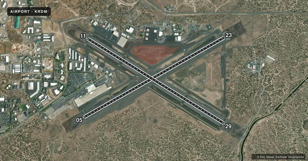
Runways & pattern
Full pagePattern entry · RWY 11
LEFT TRAFFIC| Runway | Heading (°M) | Length | Surface | Traffic |
|---|---|---|---|---|
| 05/23 | 46° / 226° | 7,038 ft | ASPH | Standard L |
| 11/29Favored | 108° / 288° | 7,006 ft | ASPH | Standard L |
Runway end performance
| End | TORA | TODA | ASDA | LDA | VGSI | Approach lights | Obstruction |
|---|---|---|---|---|---|---|---|
| 05 | 7,038' | 7,038' | 7,038' | 7,038' | VASI 4-box left(3°) | — | — |
| 23 | 7,038' | 7,038' | 7,031' | 7,031' | PAPI 4-box left(3°) | MALSR | — |
| 11 | 7,006' | 7,006' | 7,006' | 7,006' | PAPI 4-box left(3°) | — | — |
| 29 | 7,006' | 7,006' | 7,006' | 7,006' | PAPI 4-box left(3°) | — | — |
Declared distances in feet. TORA = takeoff run available, TODA = takeoff distance, ASDA = accelerate-stop, LDA = landing distance.
Airport sketch
Runways drawn to scale from FAA survey coordinates, rendered over satellite imagery. Not for navigation.
Approaches & charts
ILS · 1
Services on the field
Fuel grades, oxygen, maintenance, ramp storage and lighting — as declared to the FAA by the airport operator.
Fuel & services
- Fuel
- 100LLAMOGAS
- Oxygen (bottled)
- HIGH/LOW
- Oxygen (bulk)
- HIGH/LOW
- Airframe repair
- Major
- Power plant repair
- Major
- Other services
- AFRT,AMB,AVNCS,CARGO,CHTR,INSTR,RNTL
Ramp & ground
- Transient storage
- Tie-down
- Hangar
- Landing fee
- No fee published
- Customs
- Not available
- Lighting schedule
- SEE RMK
- Beacon schedule
- SS-SR
- Beacon
- White / Green (civil land)(WG)
- Wind indicator
- Yes
- Segmented circle
- No
Fuel & FBOs
Cheapest 100LL and Jet A on the field and nearby. Always confirm with the FBO before taxi.
Airport notes
Surface conditions, obstructions, local procedures, lighting outages and other notes published with each FAA cycle.
General notes
- OCNL WILDLIFE ON AND INVOF ARPT.
- TERMINAL APRON NOT AVBL FOR GENERAL AVIATION ACFT.
- TRANSIENT HELICOPTER OPS PREFERRED NORTH (CONCRETE) GENERAL AVIATION RAMP.
- FOR CD IF UNA TO CTC ON FSS FREQ, CTC SEATTLE ARTCC AT 253-351-3694.
- COLD TEMPERATURE AIRPORT. ALTITUDE CORRECTION REQUIRED AT OR BELOW -16C.
- PILOTS CONDUCTING EFVS OPS; BE AWARE LED ALS IN USE RWY 23.
Lighting notes
- WHEN ATCT CLSD ACTVT HIRL RY 05/23, MIRL RY 11/29, MALSR RY 23, REIL RY 05, 11 & 29, AND TWY LGTS - CTAF.
Runway surface & condition
- 05/23PCR VALUE: 530/F/A/X/T
- 11/29PCR VALUE: 530/F/A/X/T
- H1PVT USE HELIPAD, CTC TWR. WHEN TWR CLSD USE CTAF.
Approach & departure obstructions
- 29UNUSBL BYD 5.0 NM FM THD, DOES NOT PRVD OBSTN CLNC.
Other notes
- ESTABD PRIOR TO 1959.
- 1FOR FUEL AFT HRS CALL FBO 541-504-3848. UNICOM: FBO 122.85.
- AMBLIFE FLIGHT
- AVNCSBY APPOINTMENT ONLY
VFR map & nearby airports
VFR sectional. Tap any ICAO chip to open that airport.
Key facts · KRDM
Answer card- ICAO
- KRDM
- Name
- ROBERTS FLD/REDMOND MUNI
- Location
- REDMOND, OREGON
- Elevation
- 3,081.5 ft MSL
- Traffic pattern altitude
- 4,081.5 ft MSL (1,000 AGL)
- Control tower
- Towered · 0600-2200
- Total runways
- 2
- Longest runway
- 05/23 · 7,038 ft
- Published ILS approaches
- 1
- Published frequencies
- 6
- Magnetic variation
- 14°
- Current flight rules
- VFR
- Current wind
- 150° at 6 kt
- Favored runway now
- RWY 11
Roberts Field sits in Redmond, Oregon at 3,081.5 ft MSL. It has two asphalt runways. The longest is runway 05/23 at 7,038 ft. Runway 11/29 is 7,006 ft. The tower is open from 0600 to 2200. One ILS approach is published for runway 23.
Pattern altitude is not published. Use standard 1,000 ft AGL for light piston operations unless the current Chart Supplement says otherwise. That puts the pattern at about 4,081.5 ft MSL based on the field elevation. Verify before you fly. Skyservice is on the field. It carries 100LL, Jet A and Jet A Prist. Call them at (541) 504-3848 for current service or after-hours fuel. The airport also notes that avionics service is by appointment only.
This is a cold temperature airport. Altitude correction is required at or below minus 16 degrees Celsius. The field also has published lighting procedures for when the tower is closed. If you are arriving at night, check the current Chart Supplement for the lighting setup and any local procedures. Runway 23 has LED approach lighting in use. The airport has been established since before 1959. Expect a busy central Oregon field with Life Flight activity. Transient helicopter operations are preferred on the north concrete general aviation ramp.