METAR & TAF KOTH
Current METAR
Observed 12:54Z
KOTH 221254Z 16005KT 10SM OVC003 13/13 A2994
- Wind
- 160° @ 5 kt
- Visibility
- 10 SM
- Temp / Dew
- 13°C / 13°C
- Altimeter
- 29.94 inHg
- Clouds
- OVC
- Density alt
- -243 ft
- Ceiling
- 300 ft AGL
- Rules
- LIFR
Airport info & contacts
Manager on record, flight service, ARTCC, attendance schedule and pattern altitude — published by the FAA and refreshed every 28 days.
Location
- From city
- 1 NM NW
- VFR sectional
- KLAMATH FALLS
- ARTCC
- ZSE · SEATTLE
- NOTAM facility
- OTH (NOTAM-D)
Airport manager
- Name
- RODGER CRADDOCK
- Phone
- 541-756-8531
- Address
- 1100 AIRPORT LANE, FLOOR 3, NORTH BEND OR 97459-2079
Flight service · Hours
- FSS MMV
- MC MINNVILLE1-800-WX-BRIEF
- Attendance
- 0500-2100
Frequencies
Tap any row to copy the frequency to your clipboard.
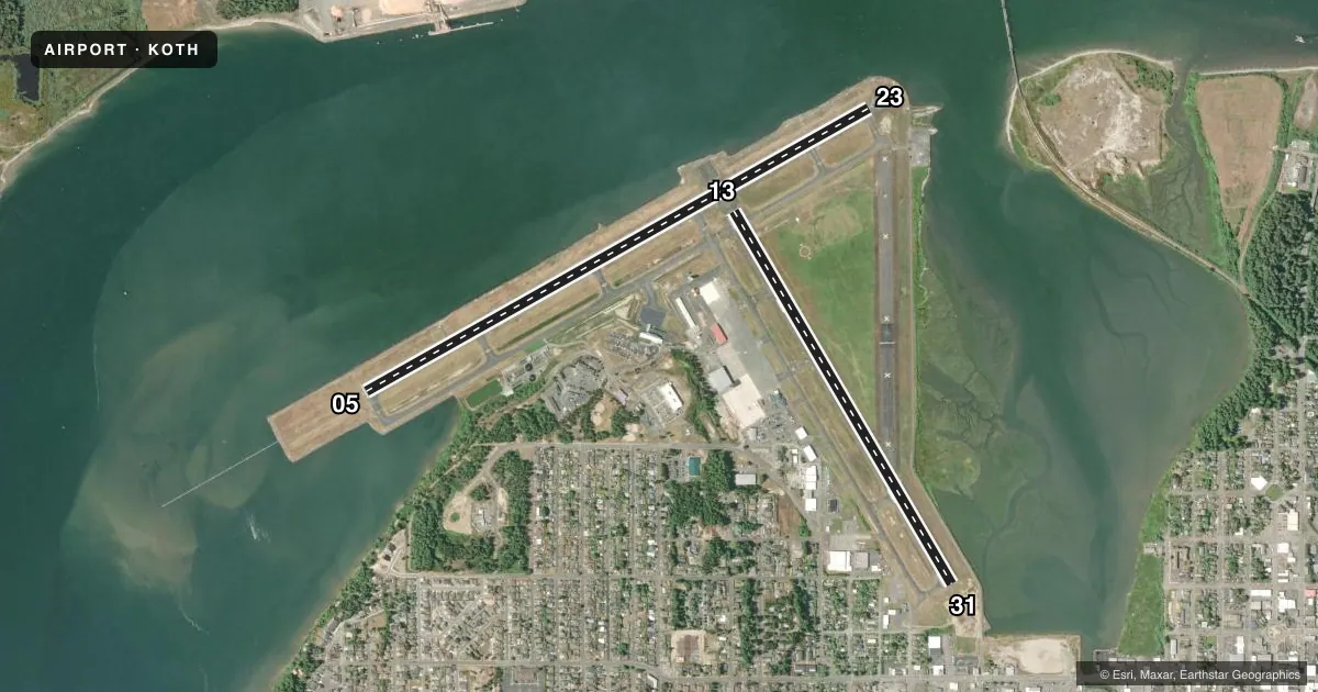
Runways & pattern
Full pagePattern entry · RWY 13
LEFT TRAFFIC| Runway | Heading (°M) | Length | Surface | Traffic |
|---|---|---|---|---|
| 05/23 | 46° / 226° | 5,980 ft | ASPH | Standard L |
| 13/31Favored | 135° / 315° | 4,470 ft | ASPH | 31 R |
Runway end performance
| End | TORA | TODA | ASDA | LDA | VGSI | Approach lights | Obstruction |
|---|---|---|---|---|---|---|---|
| 05 | 5,320' | 5,320' | 5,320' | 5,320' | PAPI 4-box right(3°) | MALSR | 144', boat, 3700' from thr, slope 25 |
| 23 | 5,980' | 5,980' | 5,980' | 5,320' | — | — | 144', boat, 1320' from thr, 550' R of cntrln, slope 8 |
| 13 | 4,470' | 4,470' | 4,470' | 4,470' | — | — | 144', boat, 1740' from thr, 0' R of cntrln, slope 11 |
| 31 | 4,470' | 4,470' | 4,470' | 4,470' | PAPI 4-box left(4°) | — | 13', road, 200' from thr, 250' R of cntrln, slope 0 |
Declared distances in feet. TORA = takeoff run available, TODA = takeoff distance, ASDA = accelerate-stop, LDA = landing distance.
Airport sketch
Runways drawn to scale from FAA survey coordinates, rendered over satellite imagery. Not for navigation.
Approaches & charts
ILS · 1
Services on the field
Fuel grades, oxygen, maintenance, ramp storage and lighting — as declared to the FAA by the airport operator.
Fuel & services
- Fuel
- 100LLA
- Airframe repair
- Major
- Power plant repair
- Major
- Other services
- AFRT,AMB,CHTR,INSTR,RNTL,SALES
Ramp & ground
- Transient storage
- Tie-down
- Hangar
- Landing fee
- Yes
- Customs
- Not available
- Lighting schedule
- SEE RMK
- Beacon schedule
- SS-SR
- Beacon
- White / Green (civil land)(WG)
- Wind indicator
- Lighted
- Segmented circle
- Yes
Fuel & FBOs
Cheapest 100LL and Jet A on the field and nearby. Always confirm with the FBO before taxi.
Airport notes
Surface conditions, obstructions, local procedures, lighting outages and other notes published with each FAA cycle.
General notes
- SHIP CHNL XS RWY 05 2/3 MI FM THLD; XS RWY 13 & RWY 23 1000 - 1700 FT FM THLD; MAST HGTS TO 144 FT.
- WATERFOWL ON & INVOF ARPT.
- ARPT USE FEES.
- PAEW INVOF RWYS & TWYS 0730-1530.
- TWY A3 CLSD OVR 60000 LB.
- FOR CD IF UNA TO CTC ON FSS FREQ, CTC SEATTLE ARTCC AT 253-351-3694.
- PILOTS CONDUCTING EFVS OPS; BE AWARE LED ALS IN USE RWY 05.
Lighting notes
- WHEN ATCT CLSD, ACTVT MALSR RWY 05; REIL RWYS 13, 23, 31; MIRL RWY 13/31; HIRL 05/23 - CTAF. PAPI RWY 05 OPR CONSLY.
Runway surface & condition
- 05/23PCR VALUE: 398/F/A/X/T
- 13/31PCR VALUE: 124/F/A/X/T
Approach & departure obstructions
- 31P4L OTS INDEFLY.
Other notes
- INDEX B AVBL WITH 4 HR PPR - 541-297-4777.
- 2AFT HR - 541-756-5181.
VFR map & nearby airports
VFR sectional. Tap any ICAO chip to open that airport.
Key facts · KOTH
Answer card- ICAO
- KOTH
- Name
- SOUTHWEST OREGON RGNL
- Location
- NORTH BEND, OREGON
- Elevation
- 17.4 ft MSL
- Traffic pattern altitude
- 1,017.4 ft MSL (1,000 AGL)
- Control tower
- Towered · 0700-2100
- Total runways
- 2
- Longest runway
- 05/23 · 5,980 ft
- Published ILS approaches
- 1
- Published frequencies
- 3
- Magnetic variation
- 15°
- Current flight rules
- LIFR
- Current wind
- 160° at 5 kt
- Favored runway now
- RWY 13
Southwest Oregon Rgnl is in North Bend, Oregon. The field elevation is 17.4 ft MSL. It has two asphalt runways. The longest is runway 05/23 at 5,980 ft. The tower is open 0700 to 2100. One ILS approach is published for runway 05. Pattern altitude is not published. Use 1,000 ft AGL for light piston traffic unless the current Chart Supplement says otherwise.
Coos Aviation is on the field. It carries 100LL, Jet A and Jet A Prist. Call (541) 756-5181 for current service details. The airport also has published use fees. Waterfowl are reported on and near the airport. A ship channel crosses runway 05 about two-thirds of a mile from the threshold. It crosses runways 13 and 23 between 1,000 and 1,700 ft from the threshold. Mast heights reach 144 ft.
When the tower is closed, lighting for runway 05, runway 13/31 and the runway end identifier lights is activated on CTAF. The PAPI for runway 05 operates continuously. The PAPI for runway 31 is out of service indefinitely. Taxiway A3 is closed to aircraft over 60,000 pounds. This is a busy coastal field with low elevation, towered operations and a mix of airline and general aviation traffic. Check the current Chart Supplement for any noise or curfew restrictions before flying in.