METAR & TAF KOSU
Current METAR
Observed 19:53Z
KOSU 271953Z 21010KT 10SM CLR 28/21 A2986 RMK AO2 SLP103 T02780206
- Wind
- 210° @ 10 kt
- Visibility
- 10 SM
- Temp / Dew
- 28°C / 21°C
- Altimeter
- 29.86 inHg
- Clouds
- CLR
- Density alt
- 2,757 ft
- Ceiling
- Unlimited
- Rules
- VFR
Airport info & contacts
Manager on record, flight service, ARTCC, attendance schedule and pattern altitude — published by the FAA and refreshed every 28 days.
Location
- From city
- 10 NM NW
- VFR sectional
- DETROIT
- ARTCC
- ZID · INDIANAPOLIS
- NOTAM facility
- OSU (NOTAM-D)
Airport manager
- Name
- KARL VON HAGEL
- Phone
- 614-292-4229
- Address
- OHIO STATE UNIV AIRPORT, 2160 WEST CASE RD, COLUMBUS OH 43235-2539
Flight service · Hours
- FSS DAY
- DAYTON1-800-WX-BRIEF
- Attendance
- 0600-2300
Frequencies
Tap any row to copy the frequency to your clipboard.
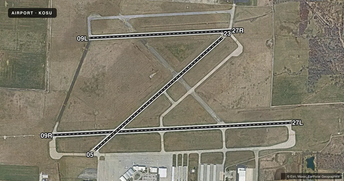
Runways & pattern
Full pagePattern entry · RWY 23
LEFT TRAFFIC| Runway | Heading (°M) | Length | Surface | Traffic |
|---|---|---|---|---|
| 09R/27L | 82° / 262° | 5,004 ft | ASPH | Standard L |
| 05/23Favored | 44° / 224° | 3,562 ft | ASPH | Standard L |
| 09L/27R | 82° / 262° | 2,994 ft | ASPH | Standard L |
Runway end performance
| End | TORA | TODA | ASDA | LDA | VGSI | Approach lights | Obstruction |
|---|---|---|---|---|---|---|---|
| 09R | 5,004' | 5,004' | 5,004' | 5,004' | PAPI 4-box left(3°) | MALSR | — |
| 27L | 5,004' | 5,004' | 5,004' | 5,004' | PAPI 4-box left(3°) | — | 53', tree, 2470' from thr, 714' R of cntrln, slope 42 |
| 05 | 3,562' | 3,562' | 3,562' | 3,562' | — | — | 37', trees, 780' from thr, 200' R of cntrln, slope 15 |
| 23 | 3,562' | 3,562' | 3,562' | 3,562' | — | — | 60', trees, 1422' from thr, 50' R of cntrln, slope 20 |
| 09L | 2,994' | 2,994' | 2,994' | 2,994' | VASI 2-box left(3°) | — | — |
| 27R | 2,994' | 2,994' | 2,994' | 2,994' | VASI 2-box left(3°) | — | 72', trees, 1545' from thr, 122' R of cntrln, slope 18 |
Declared distances in feet. TORA = takeoff run available, TODA = takeoff distance, ASDA = accelerate-stop, LDA = landing distance.
Airport sketch
Runways drawn to scale from FAA survey coordinates, rendered over satellite imagery. Not for navigation.
Approaches & charts
ILS · 1
Services on the field
Fuel grades, oxygen, maintenance, ramp storage and lighting — as declared to the FAA by the airport operator.
Fuel & services
- Fuel
- 100LLA1+
- Oxygen (bulk)
- HIGH/LOW
- Airframe repair
- Major
- Power plant repair
- Major
- Other services
- CARGO,INSTR
Ramp & ground
- Transient storage
- Tie-down
- Hangar
- Landing fee
- No fee published
- Customs
- Not available
- Lighting schedule
- SEE RMK
- Beacon schedule
- SS-SR
- Beacon
- White / Green (civil land)(WG)
- Wind indicator
- Lighted
- Segmented circle
- Yes
Fuel & FBOs
Cheapest 100LL and Jet A on the field and nearby. Always confirm with the FBO before taxi.
Airport notes
Surface conditions, obstructions, local procedures, lighting outages and other notes published with each FAA cycle.
General notes
- NOISE SENSITIVE AREA WITHIN 4 MILES TO THE NORTH AND NORTHEAST. NOISE ABATEMENT RSTRNS: NO TGL OR RPTD TKOF/LNDG 2300-0700 DLY.
- BIRDS & DEER ON & INVOF ARPT.
- ALL TWYS NORTH OF RWY 09R/27L CLSD TO UNSKED ACR OPS GTR THAN 30 PAX SEATS.
- SNOW REMOVAL OPERATING PROCEDURES: WHEN TWR CLSD ANNOUNCE ARRS/DEPS ON FREQ 118.8.
- HELIPORT (UNLIT) LOCATED NORTH SIDE AIRFIELD, ADJACENT AIR GUARD RAMP, TWY G.
- HELICOPTER LNDGS/TKFS PROHIBITED ON TWY A AND ALL RAMP AREA SOUTH OF TWY A. HELICOPTERS GROUND TAXI IF CAPABLE ON TWY A ABEAM RAMP.
- SFC CONDS UNMON 2300-0700.
- CLSD RAMP NORTH OF TWY G 24 HR PPR FOR USE (614) 292-5617.
- RWY 05/23 CLSD DLY SS-SR.
- CLSD TO PART 121 SKEDD ACR OPS GTR THAN 9 PAX SEATS; 90 DAY PPR FOR UNSKED ACR OPS GTR THAN 30 PAX SEATS - CALL AMGR.
Lighting notes
- WHEN ATCT CLSD ACTVT MALSR RWY 09R - CTAF. REIL RWY 27L; PAPI RWY 09R & 27L; VASI RWY 09L & 27R; HIRL RWY 09R/27L - OPR CONSLY MED INTST. MIRL RWY 09L/27R - OPR CONSLY LOW INTST.
Runway surface & condition
- 05/23PCR VALUE: 290/F/B/X/T
- 09L/27RPCR VALUE: 240/F/C/X/T
- 09R/27LPCR VALUE: 860/F/C/X/T
- 05/23RWY 05/23 NOT AVBL FOR PART 121/PART 380 OPS WITH SKED PAX CARRYING OPS MORE THAN 9 PAX SEATS AND NON-SKED PAX CARRYING OPS MORE THAN 30 PAX SEATS. 90 DAY PPR FOR UNSKED ACR OPS GTR THAN 30 PAX SEATS - CALL AMGR.
- 09L/27RRWY 09L/27R NOT AVBL FOR PART 121/PART 380 OPS WITH SKED PAX CARRYING OPS MORE THAN 9 PAX SEATS AND NON-SKED PAX CARRYING OPS MORE THAN 30 PAX SEATS. 90 DAY PPR FOR UNSKED ACR OPS GTR THAN 30 PAX SEATS - CALL AMGR.
- 09R/27LRWY 09R/27L NOT AVBL FOR PART 121/PART 380 OPS WITH SKED PAX CARRYING OPS MORE THAN 9 PAX SEATS AND NON-SKED PAX CARRYING OPS MORE THAN 30 PAX SEATS. 90 DAY PPR FOR UNSKED ACR OPS GTR THAN 30 PAX SEATS - CALL AMGR.
Other notes
- MANAGERARPT OPS 614-292-5580.
VFR map & nearby airports
VFR sectional. Tap any ICAO chip to open that airport.
Key facts · KOSU
Answer card- ICAO
- KOSU
- Name
- OHIO STATE UNIVERSITY
- Location
- COLUMBUS, OHIO
- Elevation
- 905.5 ft MSL
- Traffic pattern altitude
- 1,905.5 ft MSL (1,000 AGL)
- Control tower
- Towered · 0700-2300
- Total runways
- 3
- Longest runway
- 09R/27L · 5,004 ft
- Published ILS approaches
- 1
- Published frequencies
- 9
- Magnetic variation
- 5°
- Current flight rules
- VFR
- Current wind
- 210° at 10 kt
- Favored runway now
- RWY 23
Ohio State University Airport is in Columbus, Ohio. Field elevation is 905.5 ft MSL. The airport has 3 asphalt runways. The longest is 5,004 ft on 09R/27L. The control tower is open daily from 0700 to 2300. One ILS is published for runway 09R.
Pattern altitude is not published. Use 1,000 ft AGL for light piston traffic unless ATC or the current Chart Supplement says otherwise. The field sits in a busy metro area. Expect normal towered-airport flow and be ready for traffic sequencing. Runway 05/23 is closed daily from sunset to sunrise. That matters if you are planning an evening arrival or departure.
The on-field FBO is The Ohio State University Airport. It carries 100LL, Jet A and Jet A Prist. Airport operations can be reached at 614-292-5580. The ramp north of taxiway G is closed. Use there requires 24-hour prior permission. Birds and deer are reported on and near the airport. When the tower is closed, use CTAF 118.8 for runway 09R lighting activation. Check the current Chart Supplement for any published noise or curfew restrictions before flying into the field.