METAR & TAF KMTO
Current METAR
Observed 15:53Z
KMTO 271553Z AUTO 23009G17KT 10SM CLR 31/23 A2988 RMK AO2 SLP110 T03060228 TSNO
- Wind
- 230° @ 9G17 kt
- Visibility
- 10 SM
- Temp / Dew
- 31°C / 23°C
- Altimeter
- 29.88 inHg
- Clouds
- CLR
- Density alt
- 2,865 ft
- Ceiling
- Unlimited
- Rules
- VFR
Airport info & contacts
Manager on record, flight service, ARTCC, attendance schedule and pattern altitude — published by the FAA and refreshed every 28 days.
Location
- From city
- 4 NM E
- VFR sectional
- ST LOUIS
- ARTCC
- ZAU · CHICAGO
- NOTAM facility
- MTO (NOTAM-D)
Airport manager
- Name
- ANDREW FEARN
- Phone
- 217-234-7120
- Address
- 432 AIRPORT ROAD, MATTOON IL 61938
Flight service · Hours
- FSS STL
- SAINT LOUIS1-800-WX-BRIEF
- Attendance
- APR-OCT · M-F · 0700-2000
- NOV-MAR · M-F · 0700-1900
- SAT-SUN · 0700-1700
Frequencies
Tap any row to copy the frequency to your clipboard.
Runways & pattern
Full pagePattern entry · RWY 24
LEFT TRAFFIC| Runway | Heading (°M) | Length | Surface | Traffic |
|---|---|---|---|---|
| 11/29 | 110° / 290° | 6,501 ft | ASPH | 11 R |
| 06/24Favored | 57° / 237° | 5,799 ft | ASPH | 06 R |
| 18/36 | 172° / 352° | 1,098 ft | TURF | 18 R |
Runway end performance
| End | TORA | TODA | ASDA | LDA | VGSI | Approach lights | Obstruction |
|---|---|---|---|---|---|---|---|
| 11 | 6,501' | 6,501' | 6,501' | 6,501' | PAPI 4-box left(3°) | — | — |
| 29 | 6,501' | 6,501' | 6,501' | 6,501' | — | MALSR | 56', tree, 2592' from thr, 780' R of cntrln, slope 42 |
| 06 | 5,799' | 5,799' | 5,799' | 5,799' | VASI 4-box left(3°) | — | 52', tree, 2139' from thr, 103' R of cntrln, slope 37 |
| 24 | 5,799' | 5,799' | 5,799' | 5,799' | VASI 4-box left(3°) | — | — |
| 18 | 1,080' | 1,080' | 1,080' | 1,080' | — | — | — |
| 36 | 1,080' | 1,080' | 1,080' | 1,080' | — | — | — |
Declared distances in feet. TORA = takeoff run available, TODA = takeoff distance, ASDA = accelerate-stop, LDA = landing distance.
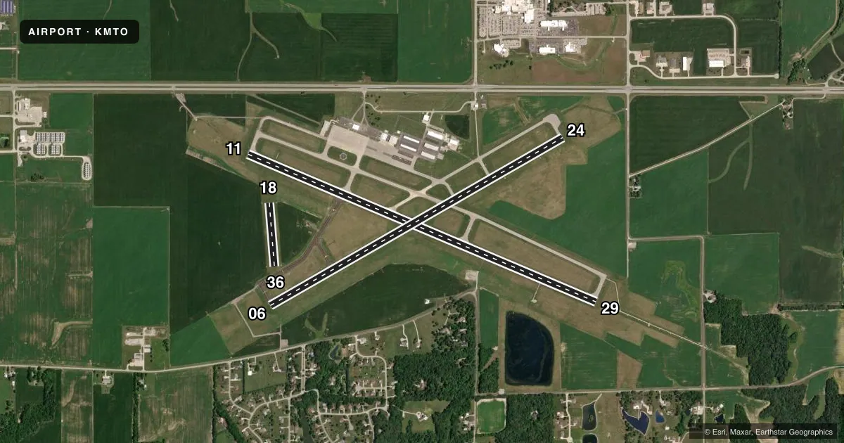
Airport sketch
Runways drawn to scale from FAA survey coordinates, rendered over satellite imagery. Not for navigation.
Approaches & charts
ILS · 1
Services on the field
Fuel grades, oxygen, maintenance, ramp storage and lighting — as declared to the FAA by the airport operator.
Fuel & services
- Fuel
- 100LLA
- Oxygen (bottled)
- HIGH/LOW
- Oxygen (bulk)
- Not available
- Airframe repair
- Major
- Power plant repair
- Major
- Other services
- AFRT,AGRI,AMB,CARGO,CHTR,INSTR,RNTL,SALES
Ramp & ground
- Transient storage
- Tie-down
- Hangar
- Landing fee
- No fee published
- Customs
- Not available
- Lighting schedule
- SEE RMK
- Beacon schedule
- SS-SR
- Beacon
- White / Green (civil land)(WG)
- Wind indicator
- Lighted
- Segmented circle
- Yes
Fuel & FBOs
Cheapest 100LL and Jet A on the field and nearby. Always confirm with the FBO before taxi.
Airport notes
Surface conditions, obstructions, local procedures, lighting outages and other notes published with each FAA cycle.
General notes
- BIRDS ON & INVOF ARPT.
- ARPT SFC COND NOT MONITORED BTN 2300Z-1300Z.
- FOR CD CTC CHAMPAIGN APCH AT 217-355-4071, WHEN APCH CLSD CTC CHICAGO ARTCC AT 630-906-8921
Lighting notes
- ACTVT MALSR RWY 29; REIL RWY 06, 11 & 24; MIRL RWY 06/24 - CTAF. ACTVT HIRL RWY 11/29 & INCR INTST - CTAF.
Runway surface & condition
- 06/24PCR VALUE: 680/F/D/X/T
- 11/29PCR VALUE: 2110/F/D/X/T
- 18/36RWY 18/36 NOT AVBL FOR PART 121/PART 380 OPS WITH SKED PAX CARRYING OPS MORE THAN 9 PAX SEATS AND NON-SKED PAX CARRYING OPS MORE THAN 30 PAX SEATS.
Approach & departure obstructions
- 18CORNER STONE MARKERS; LENGTH & WIDTH.
Other notes
- CLSD TO SKEDD ACR OPNS GTR THAN 9 PAX SEATS. UNSCHEDULED ACR OPNS GTR THAN 30 PAX SEATS, 24-HR PPR - CALL AMGR 217-234-7120.
VFR map & nearby airports
VFR sectional. Tap any ICAO chip to open that airport.
Key facts · KMTO
Answer card- ICAO
- KMTO
- Name
- COLES COUNTY MEML
- Location
- MATTOON/CHARLESTON, ILLINOIS
- Elevation
- 722.3 ft MSL
- Traffic pattern altitude
- 1,722.3 ft MSL (1,000 AGL)
- Control tower
- Non-towered (use CTAF)
- Total runways
- 3
- Longest runway
- 11/29 · 6,501 ft
- Published ILS approaches
- 1
- Published frequencies
- 4
- Magnetic variation
- 3°
- Current flight rules
- VFR
- Current wind
- 230° at 9 kt
- Favored runway now
- RWY 24
Coles County Memorial Airport sits in Mattoon/Charleston, Illinois. Field elevation is 722.3 ft MSL. The airport has three runways. The longest is runway 11/29 at 6,501 ft. Runway 06/24 is 5,799 ft. Runway 18/36 is a 1,098 ft turf strip.
This is an untowered field. Traffic should use CTAF 122.7. The published pattern altitude is not listed, so use the standard 1,000 ft AGL for light piston operations unless the current Chart Supplement says otherwise. The field has one ILS approach to runway 29. That makes 29 the runway to study if the weather is coming down.
Coles County Aviation is on the field. It carries 100LL and Jet A Prist. Call (217) 234-8146 for current service details. The published remarks also note MALSR on runway 29. REIL is available for runways 06, 11 and 24. Runway 11/29 has high-intensity lighting. Runway 06/24 has medium-intensity lighting on CTAF.
First-time visitors should pay attention to the published operating limits. Runway 18/36 is not available for certain larger passenger-carrying operations. Scheduled aircraft operations over 9 passenger seats are closed. Birds are also reported on and near the airport. Check the current Chart Supplement for any noise or curfew restrictions before flying in.