METAR & TAF KMTH
Current METAR
Observed 08:53Z
KMTH 280853Z AUTO 24004KT 10SM FEW023 28/24 A2989 RMK AO2 SLP121 T02830239 55007 $
- Wind
- 240° @ 4 kt
- Visibility
- 10 SM
- Temp / Dew
- 28°C / 24°C
- Altimeter
- 29.89 inHg
- Clouds
- FEW
- Density alt
- 1,606 ft
- Ceiling
- Unlimited
- Rules
- VFR
Airport info & contacts
Manager on record, flight service, ARTCC, attendance schedule and pattern altitude — published by the FAA and refreshed every 28 days.
Location
- From city
- 3 NM E
- VFR sectional
- MIAMI
- ARTCC
- ZMA · MIAMI
- NOTAM facility
- MTH (NOTAM-D)
Airport manager
- Name
- MICHAEL LEGERE
- Phone
- 305-289-6302
- Address
- 9400 OVERSEAS HWY SUITE 200, MARATHON FL 33050
Flight service · Hours
- FSS MIA
- MIAMI1-800-WX-BRIEF
- Attendance
- 0800-1800
Frequencies
Tap any row to copy the frequency to your clipboard.
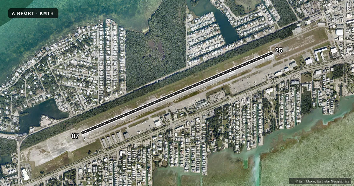
Runways & pattern
Full pagePattern entry · RWY 25
LEFT TRAFFICRunway end performance
| End | TORA | TODA | ASDA | LDA | VGSI | Approach lights | Obstruction |
|---|---|---|---|---|---|---|---|
| 07 | 5,008' | 5,008' | 5,008' | 5,008' | PAPI 4-box left(3°) | — | 40', tree, 1700' from thr, 80' R of cntrln, slope 37 |
| 25 | 5,008' | 5,008' | 5,008' | 5,008' | PAPI 4-box left(3°) | — | 65', tree, 2440' from thr, 150' R of cntrln, slope 34 |
Declared distances in feet. TORA = takeoff run available, TODA = takeoff distance, ASDA = accelerate-stop, LDA = landing distance.
Airport sketch
Runways drawn to scale from FAA survey coordinates, rendered over satellite imagery. Not for navigation.
Approaches & charts
Services on the field
Fuel grades, oxygen, maintenance, ramp storage and lighting — as declared to the FAA by the airport operator.
Fuel & services
- Fuel
- 100LLA1+
- Oxygen (bottled)
- HIGH/LOW
- Oxygen (bulk)
- HIGH/LOW
- Airframe repair
- Minor
- Power plant repair
- Minor
- Other services
- AGRI,INSTR,RNTL,SALES
Ramp & ground
- Transient storage
- Tie-down
- Landing fee
- No fee published
- Customs
- Not available
- Lighting schedule
- SEE RMK
- Beacon schedule
- SS-SR
- Beacon
- White / Green (civil land)(WG)
- Wind indicator
- Lighted
- Segmented circle
- Yes
Fuel & FBOs
Cheapest 100LL and Jet A on the field and nearby. Always confirm with the FBO before taxi.
Airport notes
Surface conditions, obstructions, local procedures, lighting outages and other notes published with each FAA cycle.
General notes
- NOISE SENS AREA; USE NBAA NOISE ABATEMENT PROC; LCL ORDINANCE RQR ENG RUNUP IN DSGND AREA ON COML OR FBO RAMP FM 2300-0700 & FINES.
- BIRDS ON & INVOF ARPT.
- FOR CD IF UNA TO CTC ON FSS FREQ, CTC MIAMI ARTCC AT 305-716-1731.
- SELF SVC FUEL H24.
- USCBP USER FEE FAC OPEN THUR-MON 0900-1730. CLSD TO ARRS TUE AND WED EXCEPT ON REQ AND APVL BY USCBP. CTC USCBP AT 305-289-2029. SEE SPL NOTICES - U.S. SPL CUST REQUIREMENT.
- 24 HR PPR FOR ACFT EQUIPPED WITH WEATHER MODIFICATION OR GEOENGINEERING EQPT 305.289.6302.
- ACFT MUST USE TWY A4 FOR RWY 25 FULL LEN DEP, NO RWY ACES BYD TXY A4.
Lighting notes
- ACTVT REIL RWY 07; PAPI RWY 07 & 25; MIRL RWY 07/25 - CTAF.
Fuel notes
- A1+AFT HR JET-A FUEL - 305-481-7615.
Runway surface & condition
- 07/25PCR VALUE: 200/F/A/X/T
Other notes
- EXISTED PRIOR TO 1959.
- 48 HR PPR FOR UNSKED PART 121 OPS WITH GTR THAN 30 PAX SEATS.
VFR map & nearby airports
VFR sectional. Tap any ICAO chip to open that airport.
Key facts · KMTH
Answer card- ICAO
- KMTH
- Name
- THE FLORIDA KEYS MARATHON INTL
- Location
- MARATHON, FLORIDA
- Elevation
- 7.3 ft MSL
- Traffic pattern altitude
- 1,007.3 ft MSL (1,000 AGL)
- Control tower
- Non-towered (use CTAF)
- Total runways
- 1
- Longest runway
- 07/25 · 5,008 ft
- Published ILS approaches
- 0
- Published frequencies
- 2
- Magnetic variation
- 4°
- Current flight rules
- VFR
- Current wind
- 240° at 4 kt
- Favored runway now
- RWY 25
The Florida Keys Marathon Intl is in Marathon, Florida. Field elevation is 7.3 ft MSL. The airport has one runway, 07/25 and the longest runway is 5,008 ft of asphalt. There is no control tower. CTAF and UNICOM are both 122.975. No ILS approaches are published here, so plan with the current chart and your own approach setup.
Pattern altitude is not published. Use the standard 1,000 ft AGL for light piston traffic unless local procedures or ATC say otherwise. Million Air is on the field. It carries 100LL, Jet A and Jet A Prist. Self-serve fuel is available 24 hours a day. After-hours Jet A is available by phone.
This is a noise sensitive airport. Use NBAA noise abatement procedures. Local rules also require engine runup in designated areas on commercial or FBO ramps from 2300 to 0700. Birds are reported on and near the airport, so expect wildlife vigilance on taxi, takeoff and landing. Runway 25 departures require the full length of taxiway A4. There is no runway access beyond A4. Customs is available on a limited schedule, so verify the current U.S. Customs and Border Protection requirements before an international arrival.