METAR & TAF KEYW
Current METAR
Observed 04:53Z
KEYW 280453Z AUTO 27003KT 10SM CLR 29/24 A2992 RMK AO2 SLP139 T02890244 403170244 $
- Wind
- 270° @ 3 kt
- Visibility
- 10 SM
- Temp / Dew
- 29°C / 24°C
- Altimeter
- 29.92 inHg
- Clouds
- CLR
- Density alt
- 1,684 ft
- Ceiling
- Unlimited
- Rules
- VFR
Airport info & contacts
Manager on record, flight service, ARTCC, attendance schedule and pattern altitude — published by the FAA and refreshed every 28 days.
Location
- From city
- 2 NM E
- VFR sectional
- MIAMI
- ARTCC
- ZMA · MIAMI
- NOTAM facility
- EYW (NOTAM-D)
Airport manager
- Name
- RICHARD STRICKLAND
- Phone
- 305-809-5200
- Address
- 3491 S ROOSEVELT BLVD, KEY WEST FL 33040-5260
Flight service · Hours
- FSS MIA
- MIAMI1-800-WX-BRIEF
- Attendance
- 0700-2300
Frequencies
Tap any row to copy the frequency to your clipboard.
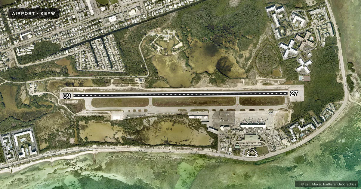
Runways & pattern
Full pagePattern entry · RWY 27
LEFT TRAFFICRunway end performance
| End | TORA | TODA | ASDA | LDA | VGSI | Approach lights | Obstruction |
|---|---|---|---|---|---|---|---|
| 09 | 5,076' | 5,076' | 5,076' | 4,801' | PAPI 4-box left(3°) | — | 22', tree, 745' from thr, 200' R of cntrln, slope 24 |
| 27 | 4,801' | 4,801' | 4,801' | 4,801' | PAPI 4-box right(3°) | — | 10', brush, 555' from thr, 260' R of cntrln, slope 34 |
Declared distances in feet. TORA = takeoff run available, TODA = takeoff distance, ASDA = accelerate-stop, LDA = landing distance.
Airport sketch
Runways drawn to scale from FAA survey coordinates, rendered over satellite imagery. Not for navigation.
Approaches & charts
Services on the field
Fuel grades, oxygen, maintenance, ramp storage and lighting — as declared to the FAA by the airport operator.
Fuel & services
- Fuel
- 100LLA
- Oxygen (bottled)
- Low pressure
- Oxygen (bulk)
- Not available
- Airframe repair
- Major
- Power plant repair
- Major
- Other services
- AMB,CHTR,INSTR,RNTL,SALES
Ramp & ground
- Transient storage
- Tie-down
- Landing fee
- No fee published
- Customs
- Available
- Lighting schedule
- SEE RMK
- Beacon schedule
- SS-SR
- Beacon
- White / Green (civil land)(WG)
- Wind indicator
- Lighted
- Segmented circle
- Yes
Fuel & FBOs
Cheapest 100LL and Jet A on the field and nearby. Always confirm with the FBO before taxi.
Airport notes
Surface conditions, obstructions, local procedures, lighting outages and other notes published with each FAA cycle.
General notes
- BIRDS ON & INVOF ARPT.
- R-2916 LCTD 14 NM NE OF ARPT HAS STROBE LGT, MKD BLN & CABLE TO 14000 FT.
- MIL JET TFC S & E OF ARPT; ACFT ENTERING TFC AREA FM SE THRU W.
- ENTER TFC AREA BLW 2000 FT; REFER TO MIAMI VFR TAC FOR SUG VFR FLYWAY RTES.
- NOISE SENSITIVE AREA; USE NBAA NOISE ABATEMENT PROC OTR TIMES; ENG RUNUPS IN DSGND AREA ON TWY A BTN TWY B10 & TWY B11; NO OPS 2300-0700 .
- PPR FOR WINGSPAN MORE THAN 118 FT OR EXCEEDING RWY WT BRG CPTY - AMGR.
- VFR DEP MNTN RWY HDG TIL RCHG FLD BOUNDARY THEN EXACT TURN N OR S.
- TWY B5 NOT VSB FM ATCT.
- FOR CD IF UNA TO CTC ON FSS FREQ, CTC MIAMI ARTCC AT 305-716-1731.
Lighting notes
- ACTVT REIL RWY 09 & 27; PAPI RWY 09 & 27; MIRL RWY 09/27 - CTAF.
Runway surface & condition
- 09/27PCR VALUE: 370/F/B/X/T
Approach & departure obstructions
- 09RWY 09 APRCH SLP 46:1 TO MKD DSPLCD THR.
Arresting gear
- 09_EMASENGRD MTRLS ARSTG SYS (EMAS) 340 FT IN LEN BY 120 FT IN WID LCTD AT THE DER 09.
- 27_EMASENGRD MTRLS ARSTG SYS (EMAS) 274 FT IN LEN BY 122 FT IN WID LCTD 307 FT FM THR OF THE DER 27.
Other notes
- CUST & BDR PATROL 0800-2000 MON-SAT; CLSD SUN.
- PPR FOR UNSKED ACR OPS MORE THAN 30 PAX SEATS 2330-0545 - AMGR.
VFR map & nearby airports
VFR sectional. Tap any ICAO chip to open that airport.
Key facts · KEYW
Answer card- ICAO
- KEYW
- Name
- KEY WEST INTL
- Location
- KEY WEST, FLORIDA
- Elevation
- 3.4 ft MSL
- Traffic pattern altitude
- 1,003.4 ft MSL (1,000 AGL)
- Control tower
- Towered · 0700-2100
- Total runways
- 1
- Longest runway
- 09/27 · 5,076 ft
- Published ILS approaches
- 0
- Published frequencies
- 13
- Magnetic variation
- 4°
- Current flight rules
- VFR
- Current wind
- 270° at 3 kt
- Favored runway now
- RWY 27
Key West Intl is in Key West, Florida. Field elevation is 3.4 ft MSL. The airport has one runway, 09/27, which is 5,076 ft long. The control tower is open 0700-2100. No ILS approaches are published here. Pattern altitude is not published, so use the standard 1,000 ft AGL for light piston traffic unless the current Chart Supplement says otherwise.
Signature Aviation is on the field. It carries AVGAS 100LL and Jet A. The airport has several operational notes that matter on a first visit. Noise sensitive operations apply. Use NBAA noise abatement procedures at other times. Engine runups are only permitted in the designated area on taxiway A between taxiways B10 and B11. No operations are allowed from 2300 to 0700. Military jet traffic is south and east of the airport. Enter the traffic area below 2000 ft. VFR departures are expected to hold runway heading until the field boundary, then make an exact turn north or south.
The field sits very close to sea level, so density altitude is usually not the main issue. Traffic flow and local procedures matter more. Runway 27 has EMAS near the departure end. Birds are reported on and near the airport. Check the current FAA Chart Supplement and the airport operator for any current restrictions before you go.