METAR & TAF KMSY
Current METAR
Observed 07:53Z
KMSY 280753Z 27006KT 10SM FEW250 27/25 A2988 RMK AO2 SLP121 T02670250 $
- Wind
- 270° @ 6 kt
- Visibility
- 10 SM
- Temp / Dew
- 27°C / 25°C
- Altimeter
- 29.88 inHg
- Clouds
- FEW
- Density alt
- 1,493 ft
- Ceiling
- Unlimited
- Rules
- VFR
Airport info & contacts
Manager on record, flight service, ARTCC, attendance schedule and pattern altitude — published by the FAA and refreshed every 28 days.
Location
- From city
- 10 NM W
- VFR sectional
- NEW ORLEANS
- ARTCC
- ZHU · HOUSTON
- NOTAM facility
- MSY (NOTAM-D)
Airport manager
- Name
- KEVIN DOLLIOLE
- Phone
- (504) 303-7652
- Address
- PO BOX 20007, NEW ORLEANS LA 70141
Flight service · Hours
- FSS DRI
- DE RIDDER1-800-WX-BRIEF
- Attendance
- ALL
Frequencies
Tap any row to copy the frequency to your clipboard.
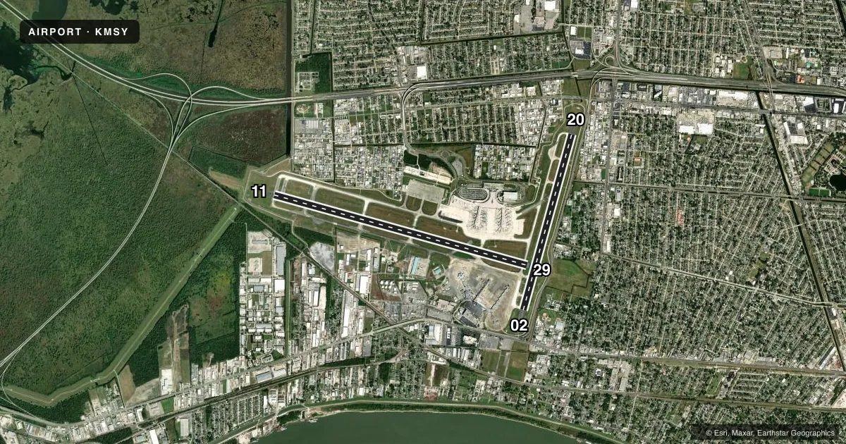
Runways & pattern
Full pagePattern entry · RWY 29
LEFT TRAFFIC| Runway | Heading (°M) | Length | Surface | Traffic |
|---|---|---|---|---|
| 11/29Favored | 104° / 284° | 10,104 ft | CONC | Standard L |
| 02/20 | 14° / 194° | 7,002 ft | CONC | Standard L |
Runway end performance
| End | TORA | TODA | ASDA | LDA | VGSI | Approach lights | Obstruction |
|---|---|---|---|---|---|---|---|
| 11 | 10,104' | 10,104' | 9,800' | 9,800' | PAPI 4-box right(2.8°) | ALSF2 | — |
| 29 | 10,104' | 10,104' | 10,104' | 9,800' | PAPI 4-box right(3°) | MALSR | 53', tree, 1557' from thr, 694' R of cntrln, slope 25 |
| 02 | 7,002' | 7,002' | 7,002' | 7,002' | PAPI 4-box left(3°) | RLLS | 12', road, 200' from thr, 365' R of cntrln, slope 0 |
| 20 | 7,002' | 7,002' | 6,948' | 6,948' | PAPI 4-box left(3°) | MALS | 13', road, 200' from thr, 289' R of cntrln, slope 0 |
Declared distances in feet. TORA = takeoff run available, TODA = takeoff distance, ASDA = accelerate-stop, LDA = landing distance.
Airport sketch
Runways drawn to scale from FAA survey coordinates, rendered over satellite imagery. Not for navigation.
Approaches & charts
ILS · 4
Services on the field
Fuel grades, oxygen, maintenance, ramp storage and lighting — as declared to the FAA by the airport operator.
Fuel & services
- Fuel
- 100LLA
- Oxygen (bottled)
- Not available
- Oxygen (bulk)
- Not available
- Airframe repair
- Not available
- Power plant repair
- Not available
- Other services
- AFRT,CARGO
Ramp & ground
- Transient storage
- Tie-down
- Landing fee
- Yes
- Customs
- Not available
- Lighting schedule
- SS-SR
- Beacon schedule
- SS-SR
- Beacon
- White / Green (civil land)(WG)
- Wind indicator
- Lighted
- Segmented circle
- No
Fuel & FBOs
Cheapest 100LL and Jet A on the field and nearby. Always confirm with the FBO before taxi.
Airport notes
Surface conditions, obstructions, local procedures, lighting outages and other notes published with each FAA cycle.
General notes
- 180 DEG & LOCKED WHEEL TURNS PROHIBITED ON ASPH SFC ACFT 12500 LBS & OVER.
- FLOCKS OF BIRDS ON & IN VICINITY OF ARPT.
- RY 11 NOISE SENSITIVE FOR DEP; AVBL FOR OPNL NECESSITY. ALL RYS NOISE SENSITIVE FOR ARR. ARRIVING TURBOJETS MUST MAKE 5 MILE FINAL APCH TO MINIMIZE NOISE.
- TWY G BTN RWY 11/29 AND TWY S SFC MOV GUIDANCE AND CTL SYSTEM U/S PERM
- TWY E TSA IS REDUCED TO 171 FT, BTW TWY A AND APCH END RWY 11 DUE TO OBSTN.
Runway surface & condition
- 02/20PCR VALUE: 600/R/D/W/T
- 11/29PCR VALUE: 1190/R/B/W/T
Approach & departure obstructions
- 02+12 FT ROAD PARALLEL TO AND 365 FT RIGHT OF CNTRLN 0-200 FT FM RY END.
- 20+13 FT ROAD PARALLEL TO AND 289 FT LEFT OF CNTRLN 0-200 FT FM RY END.
- 29+53 FT TREE, 1557 FT DIST, 694 FT R, 30:1 BASED ON DSPLCD THLD.
VFR map & nearby airports
VFR sectional. Tap any ICAO chip to open that airport.
Key facts · KMSY
Answer card- ICAO
- KMSY
- Name
- LOUIS ARMSTRONG NEW ORLEANS INTL
- Location
- NEW ORLEANS, LOUISIANA
- Elevation
- 3 ft MSL
- Traffic pattern altitude
- 1,003 ft MSL (1,000 AGL)
- Control tower
- Towered · 24
- Total runways
- 2
- Longest runway
- 11/29 · 10,104 ft
- Published ILS approaches
- 4
- Published frequencies
- 21
- Magnetic variation
- 1°
- Current flight rules
- VFR
- Current wind
- 270° at 6 kt
- Favored runway now
- RWY 29
Louis Armstrong New Orleans Intl sits in New Orleans, Louisiana. Field elevation is 3 ft MSL. The airport has 2 concrete runways. The longest is 10,104 ft on 11/29. Tower service is 24 hours. Four ILS approaches are published for runway ends 02, 11, 20 and 29.
Pattern altitude is not published in the facts. Use the current FAA Chart Supplement for the published traffic pattern information before you go. The field is in a busy metro area. Noise sensitivity is a real issue here. Runway 11 is noise sensitive for departure and is available only for optional necessity. All runways are noise sensitive for arrival. Arriving turbojets must plan a 5 mile final to help reduce noise.
Signature Aviation is on the field. It carries 100LL and Jet A. Atlantic Aviation is also on the field. It carries 100LL and Jet A. Flocks of birds are reported on and near the airport, so expect extra vigilance on arrival and departure. Taxiway G between runway 11/29 and taxiway S is permanently out of service for surface movement guidance and control. Runway 29 also has a published tree obstruction note near the threshold area. This is a low-elevation coastal airport, so the big operational focus is traffic flow, bird activity and staying sharp on taxi routing.