METAR & TAF KMIE
Current METAR
Observed 17:05Z
KMIE 271705Z VRB03KT 10SM SCT020 28/23 A2986 RMK AO2 PRESFR T02830233
- Wind
- VAR @ 3 kt
- Visibility
- 10 SM
- Temp / Dew
- 28°C / 23°C
- Altimeter
- 29.86 inHg
- Clouds
- SCT
- Density alt
- 2,797 ft
- Ceiling
- Unlimited
- Rules
- VFR
Airport info & contacts
Manager on record, flight service, ARTCC, attendance schedule and pattern altitude — published by the FAA and refreshed every 28 days.
Location
- From city
- 3 NM NW
- VFR sectional
- CHICAGO
- ARTCC
- ZID · INDIANAPOLIS
- NOTAM facility
- MIE (NOTAM-D)
Airport manager
- Name
- TIM BATY
- Phone
- 765-747-5690
- Address
- 311 W. CARL SIMMONS RD., MUNCIE IN 47303
Flight service · Hours
- FSS HUF
- TERRE HAUTE1-800-WX-BRIEF
- Attendance
- 0600-2200
Frequencies
Tap any row to copy the frequency to your clipboard.
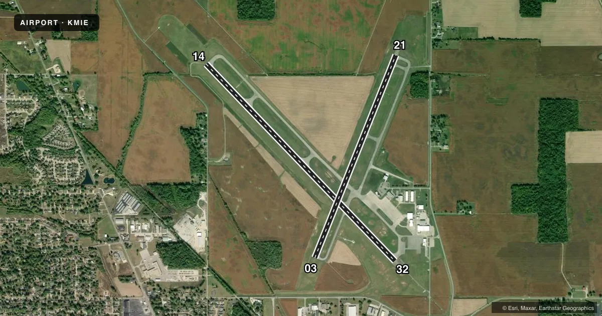
Runways & pattern
Full pagePattern entry · RWY 03
LEFT TRAFFIC| Runway | Heading (°M) | Length | Surface | Traffic |
|---|---|---|---|---|
| 14/32 | 133° / 313° | 6,500 ft | ASPH | Standard L |
| 03/21Favored | 19° / 199° | 5,198 ft | ASPH | Standard L |
Runway end performance
| End | TORA | TODA | ASDA | LDA | VGSI | Approach lights | Obstruction |
|---|---|---|---|---|---|---|---|
| 14 | 6,500' | 6,500' | 6,500' | 6,500' | PAPI 4-box left(3°) | — | 98', trees, 4200' from thr, 50' R of cntrln, slope 40 |
| 32 | 6,500' | 6,500' | 6,500' | 6,500' | — | MALSR | 73', trees, 3066' from thr, 857' R of cntrln, slope 39 |
| 03 | 5,197' | 5,197' | 5,197' | 5,197' | PAPI 4-box left(3°) | — | 58', tree, 1570' from thr, 241' R of cntrln, slope 23 |
| 21 | 5,197' | 5,197' | 5,197' | 5,197' | PAPI 4-box left(3°) | — | 44', tree, 1281' from thr, 424' R of cntrln, slope 25 |
Declared distances in feet. TORA = takeoff run available, TODA = takeoff distance, ASDA = accelerate-stop, LDA = landing distance.
Airport sketch
Runways drawn to scale from FAA survey coordinates, rendered over satellite imagery. Not for navigation.
Approaches & charts
ILS · 1
Services on the field
Fuel grades, oxygen, maintenance, ramp storage and lighting — as declared to the FAA by the airport operator.
Fuel & services
- Fuel
- 100LLA
- Oxygen (bottled)
- High pressure
- Oxygen (bulk)
- High pressure
- Airframe repair
- Minor
- Power plant repair
- Minor
- Other services
- AFRT,AVNCS,CHTR,INSTR,RNTL,SALES
Ramp & ground
- Transient storage
- Tie-down
- Hangar
- Lighting schedule
- SEE RMK
- Beacon schedule
- SS-SR
- Beacon
- White / Green (civil land)(WG)
- Wind indicator
- Lighted
- Segmented circle
- Yes
Fuel & FBOs
Cheapest 100LL and Jet A on the field and nearby. Always confirm with the FBO before taxi.
Airport notes
Surface conditions, obstructions, local procedures, lighting outages and other notes published with each FAA cycle.
General notes
- DEER ON & INVOF ARPT.
- SVC AFT HR - 765-729-1078.
- WHEN ATCT IS CLSD FOR CD CTC INDIANAPOLIS APCH AT 317-227-5743.
- SFC COND UNMNT MON-FRI 1500-0700 & WKEND.
Lighting notes
- ACTVT MALSR RWY 32; REIL RWY 3, 14 & 21; PAPI RWY 14 & 21; MIRL RWY 3/21; HIRL RWY 14/32 - CTAF. REIL RWY 3, 14 & 21 HIGH INTSTY ONLY. PAPI RWY 3 ON CONSLY.
Runway surface & condition
- 03/21PCR VALUE: 640/F/D/X/T
- 14/32PCR VALUE: 580/F/D/X/T
- 03/21RWY 03/21 NOT AVBL FOR PART 121/PART 380 OPS WITH SKED PAX CARRYING OPS MORE THAN 9 PAX SEATS AND NON-SKED PAX CARRYING OPS MORE THAN 30 PAX SEATS.
- 14/32CALM WIND RWY.
Other notes
- CLOSED TO SCHEDULED ACR OPNS GREATER THAN 9 PASSENGER SEATS. 96 HRS PPR FOR UNSKED ACR OPNS WITH MORE THAN 30 PSGR SEATS CALL AMGR 765-747-5690.
- MANAGER765-729-1078
VFR map & nearby airports
VFR sectional. Tap any ICAO chip to open that airport.
Key facts · KMIE
Answer card- ICAO
- KMIE
- Name
- DELAWARE COUNTY RGNL
- Location
- MUNCIE, INDIANA
- Elevation
- 937.4 ft MSL
- Traffic pattern altitude
- 1,937.4 ft MSL (1,000 AGL)
- Control tower
- Towered · 0600-2200
- Total runways
- 2
- Longest runway
- 14/32 · 6,500 ft
- Published ILS approaches
- 1
- Published frequencies
- 9
- Magnetic variation
- 3°
- Current flight rules
- VFR
- Current wind
- 000° at 3 kt
- Favored runway now
- RWY 03
Delaware County Rgnl is in Muncie, Indiana. The field elevation is 937.4 ft MSL. It has two asphalt runways. The longest is runway 14/32 at 6,500 ft. The airport has a control tower. Tower hours are 0600-2200. One ILS is available to runway 32. Pattern altitude is not published, so use the standard 1,000 ft AGL for light piston traffic unless ATC or the current FAA Chart Supplement says otherwise.
Muncie Aviation Company is on the field. It carries 100LL and Jet A Prist. Delaware County Regional Airport is also on the field. It carries 100LL. Deer are reported on and near the airport. That is worth keeping in mind on taxi, takeoff and landing. Runway 14/32 is the calm wind runway. Runway 32 has MALSR lighting. Runways 3, 14 and 21 have REIL. Runway 14 and runway 21 have PAPI. Runway 3/21 has MIRL. When the tower is closed, use Indianapolis Approach for clearance delivery. Surface condition is unmonitored during some overnight and weekend periods. Check current conditions before you go if weather has been active.