METAR & TAF KLWS
Current METAR
Observed 16:56Z
KLWS 271656Z 05004KT 6SM HZ CLR 23/08 A3005 RMK AO2 SLP165 T02280078 $
- Wind
- 050° @ 4 kt
- Visibility
- 6 SM
- Temp / Dew
- 23°C / 8°C
- Altimeter
- 30.05 inHg
- Clouds
- CLR
- Density alt
- 2,587 ft
- Ceiling
- Unlimited
- Rules
- VFR
Airport info & contacts
Manager on record, flight service, ARTCC, attendance schedule and pattern altitude — published by the FAA and refreshed every 28 days.
Location
- From city
- 2 NM S
- VFR sectional
- SEATTLE
- ARTCC
- ZSE · SEATTLE
- NOTAM facility
- LWS (NOTAM-D)
Airport manager
- Name
- MIKE ISAACS
- Phone
- 208-748-9132
- Address
- LEWISTON-NEZ PERCE COUNTY AIRPORT, 3632 STEARMAN ST, LEWISTON ID 83501
Flight service · Hours
- FSS BOI
- BOISE1-800-WX-BRIEF
- Attendance
- 0530-2100
Frequencies
Tap any row to copy the frequency to your clipboard.
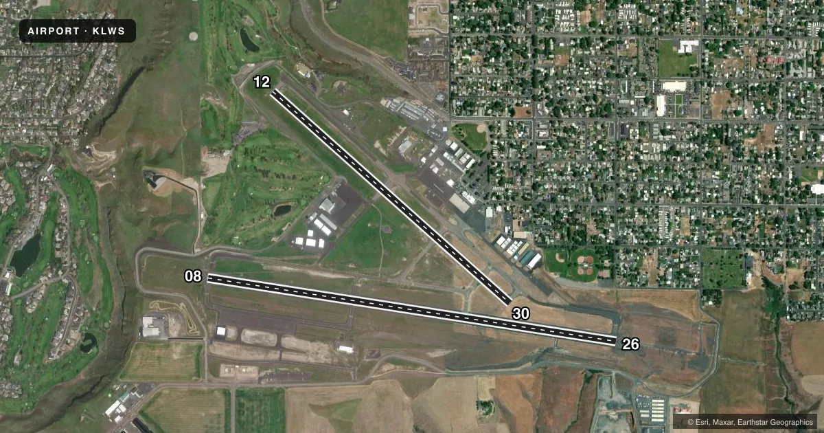
Runways & pattern
Full pagePattern entry · RWY 08
RIGHT TRAFFIC| Runway | Heading (°M) | Length | Surface | Traffic |
|---|---|---|---|---|
| 08/26Favored | 84° / 264° | 6,511 ft | ASPH | 08 R |
| 12/30 | 117° / 297° | 5,003 ft | ASPH | 12 R |
Runway end performance
| End | TORA | TODA | ASDA | LDA | VGSI | Approach lights | Obstruction |
|---|---|---|---|---|---|---|---|
| 08 | 6,511' | 6,511' | 6,511' | 6,511' | VASI 4-box left(3°) | — | — |
| 26 | 6,511' | 6,511' | 6,511' | 6,511' | PAPI 4-box left(3°) | MALSR | 185', tree, 6500' from thr, 250' R of cntrln, slope 35 |
| 12 | 5,003' | 5,003' | 4,750' | 4,750' | PAPI 2-box left(3°) | — | — |
| 30 | 5,003' | 5,003' | 5,003' | 4,750' | PAPI 2-box left(3°) | — | 33', ant, 500' from thr, 0' R of cntrln, slope 30 |
Declared distances in feet. TORA = takeoff run available, TODA = takeoff distance, ASDA = accelerate-stop, LDA = landing distance.
Airport sketch
Runways drawn to scale from FAA survey coordinates, rendered over satellite imagery. Not for navigation.
Approaches & charts
ILS · 1
Services on the field
Fuel grades, oxygen, maintenance, ramp storage and lighting — as declared to the FAA by the airport operator.
Fuel & services
- Fuel
- 100100LLA
- Oxygen (bottled)
- Not available
- Oxygen (bulk)
- Not available
- Airframe repair
- Major
- Power plant repair
- Major
- Other services
- AFRT,AGRI,AMB,CARGO,CHTR,INSTR,RNTL
Ramp & ground
- Transient storage
- Tie-down
- Hangar
- Landing fee
- No fee published
- Customs
- Not available
- Lighting schedule
- SEE RMK
- Beacon schedule
- SS-SR
- Beacon
- White / Green (civil land)(WG)
- Wind indicator
- Lighted
- Segmented circle
- Yes
Fuel & FBOs
Cheapest 100LL and Jet A on the field and nearby. Always confirm with the FBO before taxi.
Airport notes
Surface conditions, obstructions, local procedures, lighting outages and other notes published with each FAA cycle.
General notes
- (E94) LAWRS
- FREQUENT NO RADIO AGRICULTURAL ACFT ACTIVITY IN VICINITY OF ARPT.
- FOR CD IF UNA TO CTC ON FSS FREQ, CTC SEATTLE ARTCC AT 253-351-3694.
- LWS APN E HNGR RAMP CLSD TO ACRS EXC GA AND ACFT WINGSPAN LESS THAN 58 FT.
Lighting notes
- WHEN ATCT CLSD ACTVT MALSR RWY 26; REIL RWY 08; PAPI RWY 12 & RWY 30 - CTAF.
Runway surface & condition
- 08/26PCR VALUE: 720/F/B/X/T
- 12/30PCR VALUE: 360/F/A/X/T
Approach & departure obstructions
- 12PAPI UNUSBL BYD 3.5 NM.
Other notes
- CLSD TO UNSKED ACR OPNS WITH MORE THAN 30 PSGR SEATS EXCP PPR CALL AMGR 208-790-1050.
- TPA HVY AND TURBINE PWRD ACFT 1560 FT AGL ALL OTHERS 1060 FT AGL.
VFR map & nearby airports
VFR sectional. Tap any ICAO chip to open that airport.
Key facts · KLWS
Answer card- ICAO
- KLWS
- Name
- LEWISTON/NEZ PERCE COUNTY
- Location
- LEWISTON, IDAHO
- Elevation
- 1,442.1 ft MSL
- Traffic pattern altitude
- 2,442.1 ft MSL (1,000 AGL)
- Control tower
- Towered · 0600-2200
- Total runways
- 2
- Longest runway
- 08/26 · 6,511 ft
- Published ILS approaches
- 1
- Published frequencies
- 7
- Magnetic variation
- 15°
- Current flight rules
- VFR
- Current wind
- 050° at 4 kt
- Favored runway now
- RWY 08
Lewiston/Nez Perce County Airport sits in Lewiston, Idaho. Field elevation is 1,442.1 ft MSL. The airport has two asphalt runways. The longest is 08/26 at 6,511 ft. Runway 12/30 is 5,003 ft. The field has a control tower. Tower hours are 0600 to 2200. An ILS is available for runway 26.
Pattern altitude is not published in the facts for this field. Use the current FAA Chart Supplement before you go. Published remarks show the traffic pattern altitude as 1,060 ft AGL for most aircraft. Heavy and turbine aircraft use 1,560 ft AGL. That matters here because the airport also notes frequent no-radio agricultural traffic in the area. Expect to keep your scan sharp.
Hillcrest Aircraft Company is on the field. It carries 100LL, Jet A and Jet A Prist. When the tower is closed, the published lighting notes say to activate the approach lights and runway lighting on CTAF for runway 26. Use CTAF for runway 08 too. The PAPI is available for runways 12 and 30. Runway 26 also has a note that the PAPI is unusable beyond 3.5 NM. The airport is closed to unscheduled air carrier operations with more than 30 passenger seats unless prior permission is obtained from the airport manager.