METAR & TAF KLBE
Current METAR
Observed 17:52Z
KLBE 271752Z 23006KT 10SM SCT028 SCT036 28/21 A2990
- Wind
- 230° @ 6 kt
- Visibility
- 10 SM
- Temp / Dew
- 28°C / 21°C
- Altimeter
- 29.90 inHg
- Clouds
- SCT
- Density alt
- 3,071 ft
- Ceiling
- Unlimited
- Rules
- VFR
Airport info & contacts
Manager on record, flight service, ARTCC, attendance schedule and pattern altitude — published by the FAA and refreshed every 28 days.
Location
- From city
- 2 NM SW
- VFR sectional
- DETROIT
- ARTCC
- ZOB · CLEVELAND
- NOTAM facility
- LBE (NOTAM-D)
Airport manager
- Name
- GABE MONZO
- Phone
- 724-539-8100
- Address
- 148 AVIATION LANE, SUITE 103, LATROBE PA 15650-9549
Flight service · Hours
- FSS AOO
- ALTOONA1-800-WX-BRIEF
- Attendance
- ALL
Frequencies
Tap any row to copy the frequency to your clipboard.
Runways & pattern
Full pagePattern entry · RWY 24
RIGHT TRAFFICRunway end performance
| End | TORA | TODA | ASDA | LDA | VGSI | Approach lights | Obstruction |
|---|---|---|---|---|---|---|---|
| 06 | 8,222' | 8,222' | 8,222' | 8,222' | PAPI 4-box left(3°) | — | 41', pole, 762' from thr, 538' R of cntrln, slope 13 |
| 24 | 8,222' | 8,222' | 8,222' | 7,372' | PAPI 4-box left(3°) | MALSR | 58', trees, 2043' from thr, 218' R of cntrln, slope 32 |
Declared distances in feet. TORA = takeoff run available, TODA = takeoff distance, ASDA = accelerate-stop, LDA = landing distance.
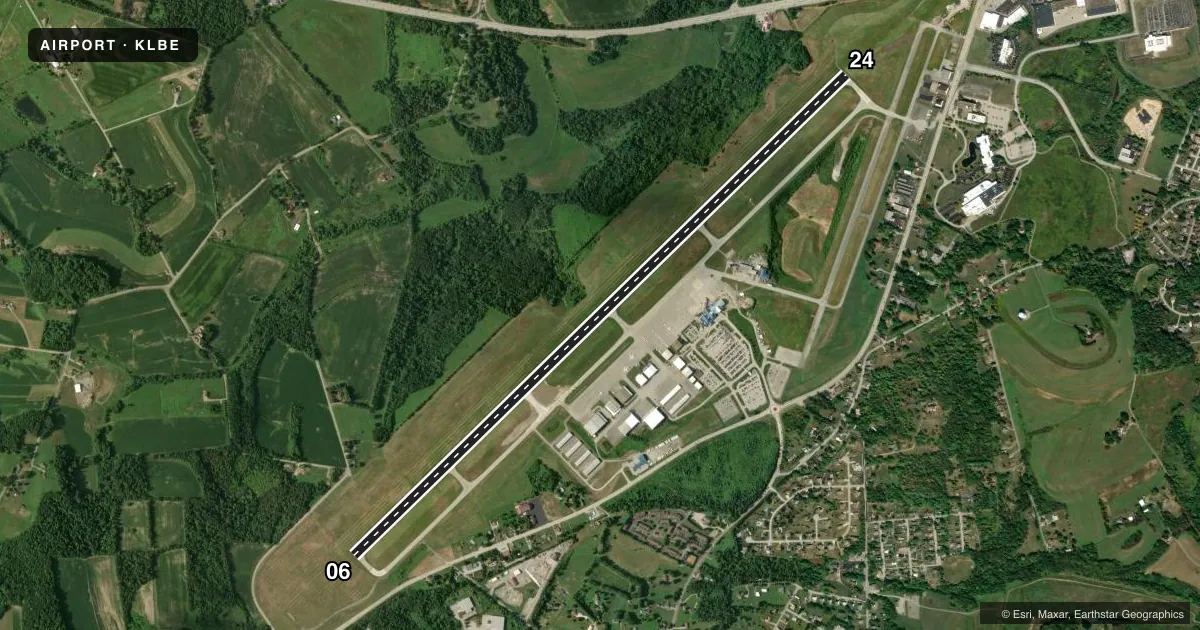
Airport sketch
Runways drawn to scale from FAA survey coordinates, rendered over satellite imagery. Not for navigation.
Approaches & charts
ILS · 1
Services on the field
Fuel grades, oxygen, maintenance, ramp storage and lighting — as declared to the FAA by the airport operator.
Fuel & services
- Fuel
- 100LLA
- Oxygen (bottled)
- High pressure
- Oxygen (bulk)
- Not available
- Airframe repair
- Major
- Power plant repair
- Major
- Other services
- AVNCS,CHTR,INSTR,RNTL,SALES
Ramp & ground
- Transient storage
- Tie-down
- Hangar
- Landing fee
- Yes
- Customs
- Not available
- Lighting schedule
- SEE RMK
- Beacon schedule
- SS-SR
- Beacon
- White / Green (civil land)(WG)
- Wind indicator
- Lighted
Fuel & FBOs
Cheapest 100LL and Jet A on the field and nearby. Always confirm with the FBO before taxi.
Airport notes
Surface conditions, obstructions, local procedures, lighting outages and other notes published with each FAA cycle.
General notes
- DEER & BIRDS ON & INVOF ARPT.
- FOR CD WHEN ATCT CLSD CTC JOHNSTOWN APCH AT 814-532-5960, WHEN APCH CLSD CTC CLEVELAND ARTCC AT 440-774-0213.
Lighting notes
- WHEN ATCT CLSD, ACTVT MALSR RWY 24; REIL RWY 06; HIRL RWY 06/24; TWY A, B, C & D - CTAF.
Runway surface & condition
- 06/24PCR VALUE: 490/F/B/X/U
Approach & departure obstructions
- 24RWY 24 PAPI UNUSBL BYD 8 DEGS RIGHT OF CNTRLN.
Other notes
- PPR 24 FOR UNSKED ACFT OPS WITH MORE THAN 9 PAX CALL AMGR 724-640-7234.
VFR map & nearby airports
VFR sectional. Tap any ICAO chip to open that airport.
Key facts · KLBE
Answer card- ICAO
- KLBE
- Name
- ARNOLD PALMER RGNL
- Location
- LATROBE, PENNSYLVANIA
- Elevation
- 1,198.7 ft MSL
- Traffic pattern altitude
- 2,198.7 ft MSL (1,000 AGL)
- Control tower
- Towered · 0615-2200
- Total runways
- 1
- Longest runway
- 06/24 · 8,222 ft
- Published ILS approaches
- 1
- Published frequencies
- 7
- Magnetic variation
- 10°
- Current flight rules
- VFR
- Current wind
- 230° at 6 kt
- Favored runway now
- RWY 24
Arnold Palmer Rgnl is in Latrobe, Pennsylvania. The field elevation is 1,198.7 ft MSL. KLBE has one runway, 06/24, which is 8,222 ft long. The tower is open daily from 0615 to 2200. One ILS approach is published for runway 24.
Pattern altitude is not published. Use 1,000 ft AGL for light piston traffic unless ATC or the current Chart Supplement says otherwise. The airport sits in western Pennsylvania terrain. Plan for local weather and performance changes on warm days. Deer and birds are reported on and near the airport. That matters here.
On the field, L.J. Aviation carries Jet A and Jet A Prist. Laurel Highlands Jet Center carries 100LL, Jet A and Jet A Prist. If you need current ramp, fuel, or parking details, call the FBO directly before arrival. When the tower is closed, clearance delivery goes through Johnstown Approach. When approach is closed, contact Cleveland ARTCC. Runway 24 PAPI is unusable beyond 8 degrees right of centerline. For larger unscheduled arrivals with more than 9 passengers, prior permission is required. Check with the airport manager before you go if that applies.