METAR & TAF KINT
Current METAR
Observed 12:54Z
KINT 271254Z 01006KT 10SM CLR 25/21 A2992 RMK AO2 SLP120 T02500206
- Wind
- 010° @ 6 kt
- Visibility
- 10 SM
- Temp / Dew
- 25°C / 21°C
- Altimeter
- 29.92 inHg
- Clouds
- CLR
- Density alt
- 2,402 ft
- Ceiling
- Unlimited
- Rules
- VFR
Airport info & contacts
Manager on record, flight service, ARTCC, attendance schedule and pattern altitude — published by the FAA and refreshed every 28 days.
Location
- From city
- 3 NM NE
- VFR sectional
- CINCINNATI
- ARTCC
- ZTL · ATLANTA
- NOTAM facility
- INT (NOTAM-D)
Airport manager
- Name
- MARK R. DAVIDSON, A.A.E.
- Phone
- 336-607-6120
- Address
- 3801 N. LIBERTY ST., STE 204, WINSTON SALEM NC 27105
Flight service · Hours
- FSS RDU
- RALEIGH1-800-WX-BRIEF
- Attendance
- ALL
Frequencies
Tap any row to copy the frequency to your clipboard.
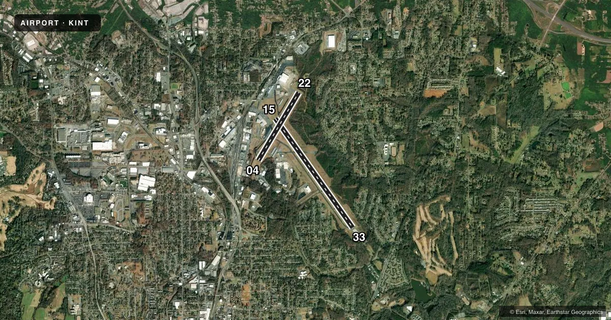
Runways & pattern
Full pagePattern entry · RWY 04
LEFT TRAFFIC| Runway | Heading (°M) | Length | Surface | Traffic |
|---|---|---|---|---|
| 15/33 | 138° / 318° | 6,655 ft | ASPH | Standard L |
| 04/22Favored | 24° / 204° | 3,938 ft | ASPH | Standard L |
Runway end performance
| End | TORA | TODA | ASDA | LDA | VGSI | Approach lights | Obstruction |
|---|---|---|---|---|---|---|---|
| 15 | 6,655' | 6,655' | 6,655' | 6,069' | PAPI 4-box left(3°) | — | 57', bldg, 1250' from thr, 450' R of cntrln, slope 18 |
| 33 | 6,655' | 6,655' | 6,655' | 6,655' | PAPI 4-box left(3°) | MALSR | — |
| 04 | 3,938' | 3,938' | 3,938' | 3,938' | — | — | 85', trees, 1700' from thr, 100' R of cntrln, slope 20 |
| 22 | 3,938' | 3,938' | 3,938' | 3,938' | PAPI 2-box left(3°) | — | 50', trees, 1400' from thr, 150' R of cntrln, slope 24 |
Declared distances in feet. TORA = takeoff run available, TODA = takeoff distance, ASDA = accelerate-stop, LDA = landing distance.
Airport sketch
Runways drawn to scale from FAA survey coordinates, rendered over satellite imagery. Not for navigation.
Approaches & charts
ILS · 1
Services on the field
Fuel grades, oxygen, maintenance, ramp storage and lighting — as declared to the FAA by the airport operator.
Fuel & services
- Fuel
- 100LLA
- Oxygen (bottled)
- HIGH/LOW
- Oxygen (bulk)
- HIGH/LOW
- Airframe repair
- Major
- Power plant repair
- Major
- Other services
- AFRT,AVNCS,CARGO,CHTR,INSTR,RNTL,SALES
Ramp & ground
- Transient storage
- Tie-down
- Hangar
- Landing fee
- No fee published
- Customs
- Not available
- Lighting schedule
- SS-SR
- Beacon schedule
- SS-SR
- Beacon
- White / Green (civil land)(WG)
- Wind indicator
- Lighted
- Segmented circle
- Yes
Fuel & FBOs
Cheapest 100LL and Jet A on the field and nearby. Always confirm with the FBO before taxi.
Airport notes
Surface conditions, obstructions, local procedures, lighting outages and other notes published with each FAA cycle.
General notes
- ARPT SFC COND NOT RPRT DLY 1630-0830L, OR ON WKEND AND HOL.
- FOR CD CTC GREENSBORO APCH AT 743-222-6129.
Runway surface & condition
- 04/22PCR VALUE: 180/F/B/X/T
- 15/33PCR VALUE: 1320/F/D/X/T
- 04/22RWY 04/22 NOT AVBL FOR PART 121/PART 380 OPS WITH SKED PAX CARRYING OPS MORE THAN 9 PAX SEATS AND NON-SKED PAX CARRYING OPS MORE THAN 30 PAX SEATS. NO PART 121/PART 380 OPS EXC FOR TAX.
- 15/33ARRESTING GEAR/SYSTEM: ENGINEERED MATERIALS ARRESTING SYSTEM (EMAS) 304 FT IN LENGTH BY 170 FT WIDTH AT THE DEPARTURE END OF RWY 15.
Approach & departure obstructions
- 15APCH RATIO 32:1 FM DSPLCD THR.
Other notes
- ARFF INDEX B COVERAGE AVBL, CALL OPS 336-607-6122.
VFR map & nearby airports
VFR sectional. Tap any ICAO chip to open that airport.
Key facts · KINT
Answer card- ICAO
- KINT
- Name
- SMITH REYNOLDS
- Location
- WINSTON SALEM, NORTH CAROLINA
- Elevation
- 969.4 ft MSL
- Traffic pattern altitude
- 1,969.4 ft MSL (1,000 AGL)
- Control tower
- Towered · 0645 - 2130
- Total runways
- 2
- Longest runway
- 15/33 · 6,655 ft
- Published ILS approaches
- 1
- Published frequencies
- 8
- Magnetic variation
- 7°
- Current flight rules
- VFR
- Current wind
- 010° at 6 kt
- Favored runway now
- RWY 04
Smith Reynolds Airport sits in Winston-Salem, North Carolina. The field elevation is 969.4 ft MSL. It has two asphalt runways. The longest is 15/33 at 6,655 ft. The tower is open daily from 0645 to 2130 local. One ILS approach is published for runway 33.
Pattern altitude is not published. Use 1,000 ft AGL for light piston traffic unless the current Chart Supplement says otherwise. Signature Aviation is on the field. It carries 100LL and Jet A. For clearance delivery, Greensboro Approach handles that call. The airport also notes that runway 04/22 is not available for Part 121 or Part 380 passenger operations except taxi. That matters if you are planning anything larger than a typical GA arrival.
The airport has a 7° magnetic variation. Expect normal towered-airport flow during the day. Surface condition reports are not published daily from 1630 to 0830 local time or on weekends and holidays. If you are arriving at night or after hours, get current field status before you launch. Runway 15 also has an engineered materials arresting system at the departure end. That is useful context if you are reading the runway notes before a first visit.