METAR & TAF KILG
Current METAR
Observed 15:51Z
KILG 271551Z VRB06KT 10SM CLR 29/21 A2985 RMK AO2 SLP106 T02890211 PNO $
- Wind
- VAR @ 6 kt
- Visibility
- 10 SM
- Temp / Dew
- 29°C / 21°C
- Altimeter
- 29.85 inHg
- Clouds
- CLR
- Density alt
- 1,866 ft
- Ceiling
- Unlimited
- Rules
- VFR
Airport info & contacts
Manager on record, flight service, ARTCC, attendance schedule and pattern altitude — published by the FAA and refreshed every 28 days.
Location
- From city
- 4 NM S
- VFR sectional
- WASHINGTON
- ARTCC
- ZNY · NEW YORK
- NOTAM facility
- ILG (NOTAM-D)
Airport manager
- Name
- BENJAMIN CLENDANIEL
- Phone
- (302) 229-6315
- Address
- 151 N. DUPONT HIGHWAY, NEW CASTLE DE 19720-0071
Flight service · Hours
- FSS MIV
- MILLVILLE1-800-WX-BRIEF
- Attendance
- ALL
Frequencies
Tap any row to copy the frequency to your clipboard.
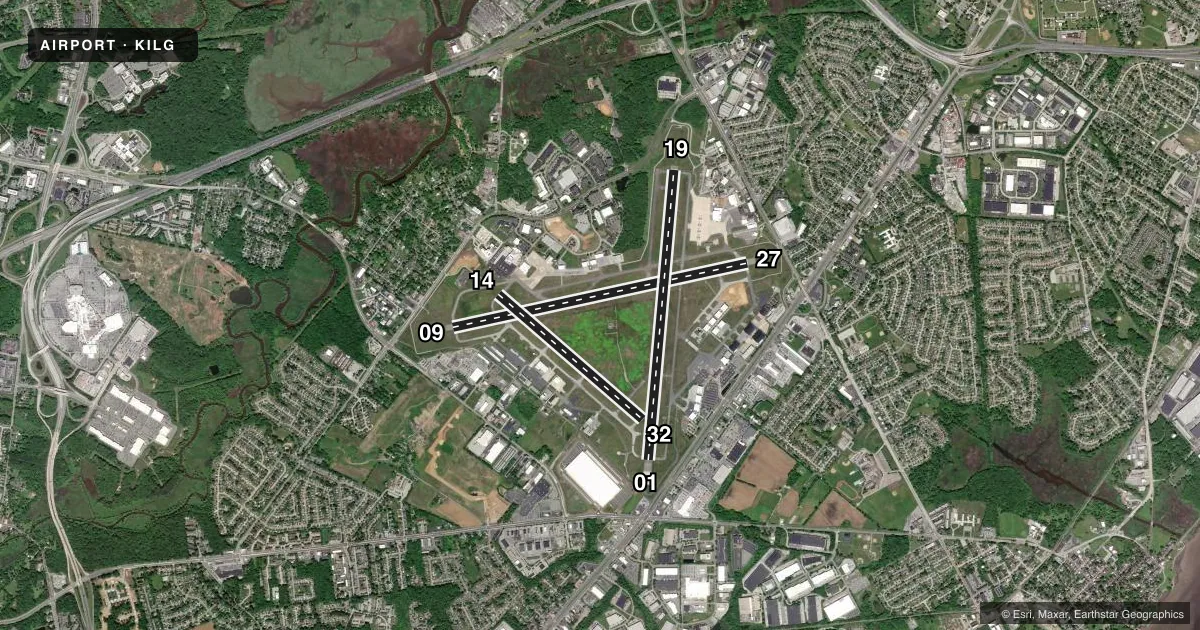
Runways & pattern
Full pagePattern entry · RWY 01
LEFT TRAFFIC| Runway | Heading (°M) | Length | Surface | Traffic |
|---|---|---|---|---|
| 09/27 | 68° / 248° | 7,275 ft | ASPH | Standard L |
| 01/19Favored | 355° / 175° | 7,012 ft | ASPH | Standard L |
| 14/32 | 121° / 301° | 4,602 ft | ASPH | Standard L |
Runway end performance
| End | TORA | TODA | ASDA | LDA | VGSI | Approach lights | Obstruction |
|---|---|---|---|---|---|---|---|
| 09 | 7,275' | 7,275' | 7,000' | 7,000' | PAPI 4-box left(3°) | — | 49', trees, 1125' from thr, 600' R of cntrln, slope 18 |
| 27 | 7,275' | 7,275' | 7,000' | 7,000' | PAPI 4-box left(3°) | — | 64', trees, 1000' from thr, 75' R of cntrln, slope 12 |
| 01 | 7,012' | 7,012' | 7,012' | 7,012' | — | MALSR | 8', road, 500' from thr, 0' R of cntrln, slope 37 |
| 19 | 7,012' | 7,012' | 7,012' | 7,012' | PAPI 4-box left(3°) | — | 72', trees, 1240' from thr, 500' R of cntrln, slope 14 |
| 14 | 4,602' | 4,602' | 4,602' | 4,602' | — | — | 43', trees, 720' from thr, 200' R of cntrln, slope 12 |
| 32 | 4,602' | 4,602' | 4,602' | 4,602' | VASI 4-box left(3°) | — | — |
Declared distances in feet. TORA = takeoff run available, TODA = takeoff distance, ASDA = accelerate-stop, LDA = landing distance.
Airport sketch
Runways drawn to scale from FAA survey coordinates, rendered over satellite imagery. Not for navigation.
Approaches & charts
ILS · 1
Services on the field
Fuel grades, oxygen, maintenance, ramp storage and lighting — as declared to the FAA by the airport operator.
Fuel & services
- Fuel
- 100LLA
- Oxygen (bottled)
- HIGH/LOW
- Oxygen (bulk)
- HIGH/LOW
- Airframe repair
- Major
- Power plant repair
- Major
- Other services
- AMB,AVNCS,CARGO,INSTR,RNTL,SALES
Ramp & ground
- Transient storage
- Tie-down
- Hangar
- Landing fee
- Yes
- Customs
- Not available
- Lighting schedule
- SEE RMK
- Beacon schedule
- SS-SR
- Beacon
- White / Green (civil land)(WG)
- Wind indicator
- Lighted
- Segmented circle
- No
Fuel & FBOs
Cheapest 100LL and Jet A on the field and nearby. Always confirm with the FBO before taxi.
Airport notes
Surface conditions, obstructions, local procedures, lighting outages and other notes published with each FAA cycle.
General notes
- BIRDS ON & INVOF ARPT.
- RWY 09/27 NO TGL FOR TURBO JET 2300-0700.
- TAXILANE 'G' NORTHWEST OF TWY 'H' LTD TO ACFT WITH WINGSPAN OF 79 FT OR LESS. TAXILANE 'G' SECTION BTW TWY 'H' & TWY 'G1' LTD TO ACFT WITH WINGSPAN OF 49 FT OR LESS.
- WHEN ATCT CLSD, PILOTS MUST ANNOUNCE INTENTIONS OVER CTAF BEFORE LDGS; TKOFS OR GND TRAVEL ON RYS & TWYS.
- PVT GND VEHICLES CROSS TWY A BTN TWYS A4 & C.
- WHEN ATCT CLSD ANNOUNCE EMERGENCIES ON CTAF DIRECTLY TO ARFF STATION.
- MILITARY: ANG: EXPECT INCR BIRD ACT (INCL WATERFOWL) DUR BASH PHASE II (MAR-MAY & SEP-NOV). CTC CASTLE OPS FOR CURRENT BIRD WATCH COND.
- TERMINAL APRON CLSD EXCEPT AIR CARRIER.
- ARNG - OPR 1200-2130Z++ WKD (OPEN ADDN HR FOR SKED TRNG), CLSD SAT, SUN AND HOL. PPR ONLY DSN 440-7205, C302-326-7205. LTD TRAN MAINT, SVC, PRK. CTC GRIFFIN OPS 46.90 10 MIN OUT.
- FOR CD WHEN ATCT IS CLSD CTC PHL APCH AT (800) 354-9884.
- TRML APRON FENCE LINE 118 FT E OF TWY A CNTRLN.
- RWY 01 5000 FT DIST RMNG SIGN MISG.
- RWY 27 5000 FT DIST RMNG SIGN MISG.
- RWY 09 2000 FT DIST RMNG SIGN MISG.
Lighting notes
- WHEN TWR CLSD ACTVT MALSR RWY 01; REIL RWY 09, 27 & 19; PAPI RWY 09 & 27; HIRL RWY 01/19 & 09/27; MIRL RWY 14/32 - CTAF.
Runway surface & condition
- 01/19PCR VALUE: 441/F/B/X/T
- 09/27PCR VALUE: 632/F/B/X/T
- 14/32PCR VALUE: 400/F/B/X/T
- 14/32RWY 14/32 NOT AVBL FOR PART 121/PART 380 OPS WITH SKED PAX CARRYING OPS MORE THAN 9 PAX SEATS AND NON-SKED PAX CARRYING OPS MORE THAN 30 PAX SEATS. NO PART 121/PART 380 OPS EXC FOR TAX.
- 14/32RWY 14/32 NON-STANDARD MILITARY ASSAULT LANDING ZONE (ALZ) LIGHTING.
Arresting gear
- 19_EMASENGINEERED MATERIAL ARRESTING SYSTEM (EMAS) 303 FT IN LENGTH BY 170 FT IN WIDTH LCTD AT DER 19.
Other notes
- LNDG FEE FOR ALL ACFT OVER 7500 LBS EXCEPT FEDERAL GOVT; MILITARY.
- OWNERLEASEE. PROPERTY OWNED BY NEW CASTLE COUNTY 87 READS WAY NEW CASTLE, DE 19720. TEL 302-395-5990.
VFR map & nearby airports
VFR sectional. Tap any ICAO chip to open that airport.
Key facts · KILG
Answer card- ICAO
- KILG
- Name
- NEW CASTLE
- Location
- WILMINGTON, DELAWARE
- Elevation
- 79.9 ft MSL
- Traffic pattern altitude
- 1,079.9 ft MSL (1,000 AGL)
- Control tower
- Towered · 0630-2300
- Total runways
- 3
- Longest runway
- 09/27 · 7,275 ft
- Published ILS approaches
- 1
- Published frequencies
- 12
- Magnetic variation
- 10°
- Current flight rules
- VFR
- Current wind
- 000° at 6 kt
- Favored runway now
- RWY 01
KILG is New Castle Airport in Wilmington, Delaware. Field elevation is 79.9 ft MSL. The airport has three asphalt runways. The longest is 09/27 at 7,275 ft. Tower service runs from 0630 to 2300. One ILS approach is published for runway 01. Pattern altitude is not published. Use the standard 1,000 ft AGL pattern for light piston traffic unless ATC or the current Chart Supplement says otherwise.
This is a busy Delaware field with multiple paved runways. The layout gives you options for wind and traffic flow. Fly the published runway headings as magnetic. The field also has bird activity noted in the remarks. That matters here, especially during the listed BASH periods in spring and fall. If you are operating a larger aircraft, note the taxilane wingspan limits on taxilane G. Runway 14/32 also has a landing fee for aircraft over 7,500 lb except federal government and military aircraft. When the tower is closed, use CTAF for airport traffic. For emergencies after hours, the published remarks direct pilots to announce on CTAF to the aircraft rescue and fire fighting station. On the field, flyADVANCED carries 100LL, Jet A and Jet A Prist. Atlantic Aviation carries 100LL and Jet A.