METAR & TAF KHYI
Current METAR
Observed 13:23Z
KHYI 271323Z 17004KT 3SM HZ OVC002 24/24 A3000 RMK AO2
- Wind
- 170° @ 4 kt
- Visibility
- 3 SM
- Temp / Dew
- 24°C / 24°C
- Altimeter
- 30.00 inHg
- Clouds
- OVC
- Density alt
- 1,718 ft
- Ceiling
- 200 ft AGL
- Rules
- LIFR
Airport info & contacts
Manager on record, flight service, ARTCC, attendance schedule and pattern altitude — published by the FAA and refreshed every 28 days.
Location
- From city
- 31 NM S
- VFR sectional
- SAN ANTONIO
- ARTCC
- ZHU · HOUSTON
- NOTAM facility
- HYI (NOTAM-D)
Airport manager
- Name
- CASSIDY BERENATO
- Phone
- 512-216-6039
- Address
- 4400 HWY 21, SUITE 200, SAN MARCOS TX 78666
Flight service · Hours
- FSS SJT
- SAN ANGELO1-800-WX-BRIEF
- Attendance
- 0700-2100
Frequencies
Tap any row to copy the frequency to your clipboard.
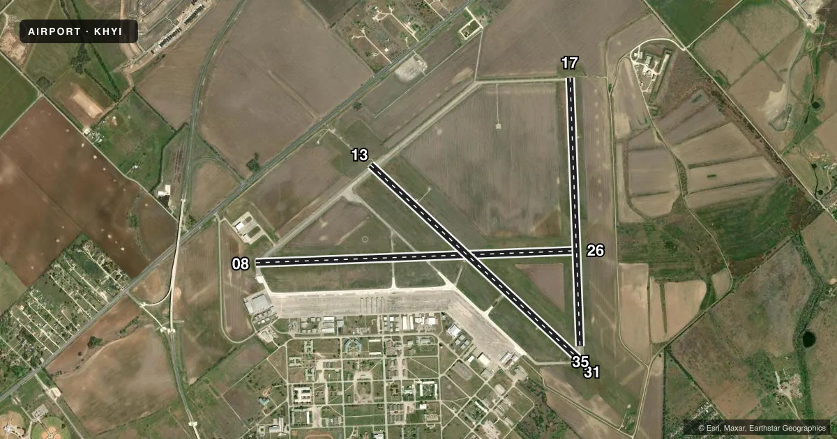
Runways & pattern
Full pagePattern entry · RWY 17
LEFT TRAFFIC| Runway | Heading (°M) | Length | Surface | Traffic |
|---|---|---|---|---|
| 08/26 | 81° / 261° | 6,330 ft | ASPH | Standard L |
| 13/31 | 126° / 306° | 5,601 ft | ASPH | Standard L |
| 17/35Favored | 171° / 351° | 5,214 ft | ASPH | Standard L |
Runway end performance
| End | TORA | TODA | ASDA | LDA | VGSI | Approach lights | Obstruction |
|---|---|---|---|---|---|---|---|
| 08 | — | — | — | — | — | — | 25', hangar, 201' from thr, 488' R of cntrln, slope 0 |
| 26 | — | — | — | — | — | — | 29', crops, 732' from thr, 425' R of cntrln, slope 18 |
| 13 | — | — | — | — | PAPI 2-box left(3°) | MALS | — |
| 31 | — | — | — | — | PAPI 2-box left(3°) | — | — |
| 17 | — | — | — | — | PAPI 2-box left(3°) | — | — |
Declared distances in feet. TORA = takeoff run available, TODA = takeoff distance, ASDA = accelerate-stop, LDA = landing distance.
Airport sketch
Runways drawn to scale from FAA survey coordinates, rendered over satellite imagery. Not for navigation.
Approaches & charts
ILS · 1
Services on the field
Fuel grades, oxygen, maintenance, ramp storage and lighting — as declared to the FAA by the airport operator.
Fuel & services
- Fuel
- 100LLA+
- Oxygen (bottled)
- Low pressure
- Airframe repair
- Major
- Power plant repair
- Major
- Other services
- AVNCS,CHTR,INSTR,RNTL,SALES
Ramp & ground
- Transient storage
- Tie-down
- Hangar
- Landing fee
- No fee published
- Customs
- Not available
- Lighting schedule
- SEE RMK
- Beacon schedule
- SS-SR
- Beacon
- White / Green (civil land)(WG)
- Wind indicator
- Lighted
- Segmented circle
- Yes
Fuel & FBOs
Cheapest 100LL and Jet A on the field and nearby. Always confirm with the FBO before taxi.
Airport notes
Surface conditions, obstructions, local procedures, lighting outages and other notes published with each FAA cycle.
General notes
- FOR CD CTC AUSTIN APCH AT 512-369-7865.
- APN ALL IREG SFC.
- BIRDS AND WILDLIFE ON AND INVOF ARPT.
- TSNT ACFT PRKG AVBL ON FBO RAMP ONLY. ALL OTR RAMP AREAS RESD FOR BASED ACFT OR RQR PRIOR CDN WITH ARPT MGMT.
Lighting notes
- MALS RWY 13; MIRL RWYS 08/26, 13/31 & 17/35 PRESET LOW INTST; TO ACTVT AND INCR INTST - CTAF.
Fuel notes
- 100LL100LL SELF SVC; 100 LL & JET A+ AVBL FULL SERVE.
Approach & departure obstructions
- 086 FT FENCE 130-199 FT DSTC, 360 FT L.
Other notes
- ESTABLISHED PRIOR TO 1940.
- 1FOR AFT HRS SVC 800-229-2379. CALL-IN FEE.
VFR map & nearby airports
VFR sectional. Tap any ICAO chip to open that airport.
Key facts · KHYI
Answer card- ICAO
- KHYI
- Name
- SAN MARCOS RGNL
- Location
- AUSTIN, TEXAS
- Elevation
- 594.7 ft MSL
- Traffic pattern altitude
- 1,594.7 ft MSL (1,000 AGL)
- Control tower
- Towered · 0700-2100 EFF 01 APR 2021
- Total runways
- 3
- Longest runway
- 08/26 · 6,330 ft
- Published ILS approaches
- 1
- Published frequencies
- 8
- Magnetic variation
- 7°
- Current flight rules
- LIFR
- Current wind
- 170° at 4 kt
- Favored runway now
- RWY 17
KHYI is San Marcos Rgnl in Austin, Texas. The field sits at 594.7 ft MSL. It has three asphalt runways. The longest is runway 08/26 at 6,330 ft. The airport is towered. The control tower is open 0700-2100, effective 01 Apr 2021.
One ILS approach is published for runway 13. Pattern altitude is not published. Use the standard 1,000 ft AGL for light piston traffic unless the current Chart Supplement says otherwise. Berry Aviation is on the field. It carries 100LL and Jet A Prist. Self-serve 100LL is available. Full-service 100LL and Jet A+ are also available.
A few operational items matter here. Birds and wildlife are present on and near the airport. Transient parking is on the FBO ramp only. Other ramp areas are for based aircraft or need prior coordination with airport management. The apron has irregular surfaces. Runway 13 has MALSR lighting. The runway lights on 08/26, 13/31 and 17/35 start at low intensity. Use CTAF to increase intensity. There is also a 6-foot fence near the left side of runway 08. For clearance delivery, contact Austin Approach. If you need after-hours service, call the number in the Chart Supplement or the FBO directly before you go.