METAR & TAF KHXD
Current METAR
Observed 12:50Z
KHXD 271250Z 01008KT 10SM CLR 27/26 A2987
- Wind
- 010° @ 8 kt
- Visibility
- 10 SM
- Temp / Dew
- 27°C / 26°C
- Altimeter
- 29.87 inHg
- Clouds
- CLR
- Density alt
- 1,526 ft
- Ceiling
- Unlimited
- Rules
- VFR
Airport info & contacts
Manager on record, flight service, ARTCC, attendance schedule and pattern altitude — published by the FAA and refreshed every 28 days.
Location
- From city
- 3 NM E
- VFR sectional
- CHARLOTTE
- ARTCC
- ZJX · JACKSONVILLE
- NOTAM facility
- HXD (NOTAM-D)
Airport manager
- Name
- JON REMBOLD
- Phone
- 843-255-2952
- Address
- 120 BEACH CITY ROAD, HILTON HEAD ISLAND SC 29926
Flight service · Hours
- FSS AND
- ANDERSON1-800-WX-BRIEF
- Attendance
- 0600-2200
Frequencies
Tap any row to copy the frequency to your clipboard.
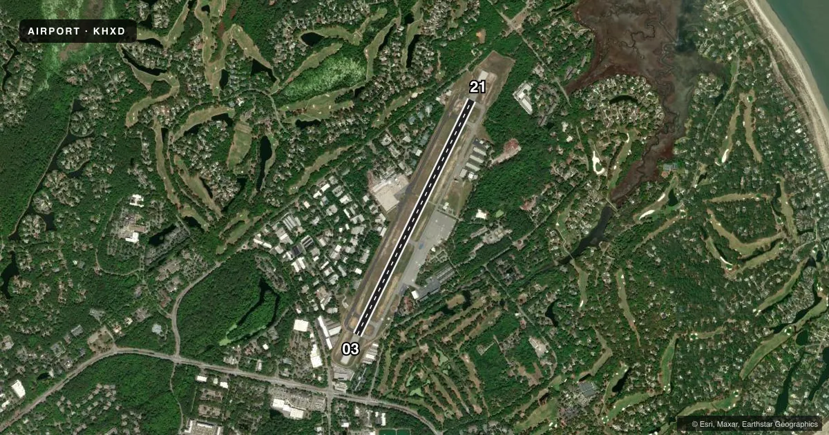
Runways & pattern
Full pagePattern entry · RWY 03
LEFT TRAFFICRunway end performance
| End | TORA | TODA | ASDA | LDA | VGSI | Approach lights | Obstruction |
|---|---|---|---|---|---|---|---|
| 03 | 5,000' | 5,000' | 5,000' | 4,703' | PAPI 4-box left(3°) | — | 56', tree, 1325' from thr, 250' R of cntrln, slope 20 |
| 21 | 5,000' | 5,000' | 5,000' | 4,597' | PAPI 4-box right(3°) | — | 55', tree, 1300' from thr, 225' R of cntrln, slope 20 |
Declared distances in feet. TORA = takeoff run available, TODA = takeoff distance, ASDA = accelerate-stop, LDA = landing distance.
Airport sketch
Runways drawn to scale from FAA survey coordinates, rendered over satellite imagery. Not for navigation.
Approaches & charts
ILS · 1
Services on the field
Fuel grades, oxygen, maintenance, ramp storage and lighting — as declared to the FAA by the airport operator.
Fuel & services
- Fuel
- 100LLA
- Oxygen (bottled)
- Not available
- Oxygen (bulk)
- Not available
- Airframe repair
- Major
- Power plant repair
- Major
- Other services
- AMB,AVNCS,CHTR,INSTR,RNTL
Ramp & ground
- Transient storage
- Tie-down
- Landing fee
- No fee published
- Customs
- Not available
- Lighting schedule
- SEE RMK
- Beacon schedule
- SS-SR
- Beacon
- White / Green (civil land)(WG)
- Wind indicator
- Lighted
- Segmented circle
- Yes
Fuel & FBOs
Cheapest 100LL and Jet A on the field and nearby. Always confirm with the FBO before taxi.
Airport notes
Surface conditions, obstructions, local procedures, lighting outages and other notes published with each FAA cycle.
General notes
- NOISE ABATEMENT PROCS IN EFC, CTC OPS (843) 255-2960.
- BIRDS ON & INVOF ARPT.
- PARASAIL OPNS WITHIN 3 NM RADIUS OF SAV 009 DEGS/15 NM, SFC TO 1500 DURG DALGT HRS.
- DEER ON AND INVOF ARPT.
Lighting notes
- ACTVT REILS RWY 03 & 21; PAPI RWY 03 & 21; MIRL RWY 03/21 - CTAF.
Runway surface & condition
- 03/21PCR VALUE: 420/F/B/X/T
Approach & departure obstructions
- 03PAPI UNUSBL BYD 7 DEGS LEFT OF CNTRLN.
- 2133:1 TO DSPLCD THLD ; TREES AT 1600 FT.
Arresting gear
- 03_EMASENGINEERED MATERIALS ARRESTING SYSTEM (EMAS) 207 FT IN LENGTH BY 105 FT IN WIDTH LCTD AT THE DER 03.
- 21_EMASENGINEERED MATERIALS ARRESTING SYSTEM (EMAS) 211 FT IN LENGTH BY 105 FT IN WIDTH LCTD AT THE DER 21.
Other notes
- CLSD TO UNSKED ACR OPNS WITH MORE THAN 30 PSGR SEATS EXCP 24 HRS PPR CALL AMGR (843) 255-2950
VFR map & nearby airports
VFR sectional. Tap any ICAO chip to open that airport.
Key facts · KHXD
Answer card- ICAO
- KHXD
- Name
- HILTON HEAD
- Location
- HILTON HEAD ISLAND, SOUTH CAROLINA
- Elevation
- 19.3 ft MSL
- Traffic pattern altitude
- 1,019.3 ft MSL (1,000 AGL)
- Control tower
- Towered · 0700-2100
- Total runways
- 1
- Longest runway
- 03/21 · 5,000 ft
- Published ILS approaches
- 1
- Published frequencies
- 8
- Magnetic variation
- 7°
- Current flight rules
- VFR
- Current wind
- 010° at 8 kt
- Favored runway now
- RWY 03
Hilton Head Airport (KHXD) sits on Hilton Head Island in South Carolina. Field elevation is 19.3 ft MSL. The airport has one runway, 03/21, which is 5,000 ft long. The tower is open daily from 0700 to 2100. One ILS approach is published for runway 21. Pattern altitude is not published, so use 1,000 ft AGL for light piston traffic unless ATC or the current Chart Supplement says otherwise.
Signature Aviation is on the field. It carries 100LL and Jet A. The airport is close to sea level, so density altitude is usually not the main issue. Traffic can still be busy because of the island location and the towered environment. Published remarks call out birds and deer in the area. Noise abatement procedures are also in effect. Contact operations for the current guidance before arrival. There is also a displaced threshold obstacle note for runway 21, plus EMAS at both runway ends. The runway lighting and PAPI are useful for night work. The PAPI on runway 03 is unusable beyond 7 degrees left of centerline. Check the current Chart Supplement for any current restrictions before flying in, especially if you are planning an unscheduled air carrier arrival.