METAR & TAF KHOU
Current METAR
Observed 09:53Z
KHOU 270953Z 00000KT 10SM FEW045 26/24 A2997 RMK AO2 SLP151 T02610244 $
- Wind
- 000° @ 0 kt
- Visibility
- 10 SM
- Temp / Dew
- 26°C / 24°C
- Altimeter
- 29.97 inHg
- Clouds
- FEW
- Density alt
- 1,315 ft
- Ceiling
- Unlimited
- Rules
- VFR
Airport info & contacts
Manager on record, flight service, ARTCC, attendance schedule and pattern altitude — published by the FAA and refreshed every 28 days.
Location
- From city
- 8 NM SE
- VFR sectional
- HOUSTON
- ARTCC
- ZHU · HOUSTON
- NOTAM facility
- HOU (NOTAM-D)
Airport manager
- Name
- STEVE RUNGE
- Phone
- 713-845-6555
- Address
- PO BOX 60106, HOUSTON TX 77205
Flight service · Hours
- FSS CXO
- MONTGOMERY COUNTY1-800-WX-BRIEF
- Attendance
- ALL
Frequencies
Tap any row to copy the frequency to your clipboard.
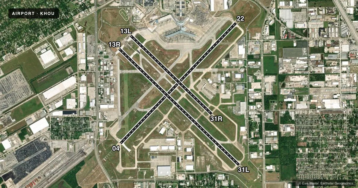
Runways & pattern
Full pagePattern entry · RWY 13R
LEFT TRAFFIC| Runway | Heading (°M) | Length | Surface | Traffic |
|---|---|---|---|---|
| 13R/31L | 131° / 311° | 7,602 ft | ASPH | Standard L |
| 04/22 | 41° / 221° | 7,602 ft | CONC | Standard L |
| 13L/31R | 131° / 311° | 5,148 ft | CONC | Standard L |
Runway end performance
| End | TORA | TODA | ASDA | LDA | VGSI | Approach lights | Obstruction |
|---|---|---|---|---|---|---|---|
| 13R | 7,602' | 7,602' | 7,602' | 6,568' | PAPI 4-box right(3°) | MALSR | 37', pole, 310' from thr, 500' R of cntrln, slope 2 |
| 31L | 7,602' | 7,602' | 7,602' | 7,602' | PAPI 4-box left(3°) | — | 13', road, 200' from thr, 500' R of cntrln, slope 0 |
| 04 | 7,602' | 7,602' | 7,602' | 7,602' | PAPI 4-box right(3°) | ALSF2 | — |
| 22 | 7,602' | 7,602' | 7,602' | 7,602' | PAPI 4-box left(3°) | MALS | 125', pole, 4400' from thr, 1000' R of cntrln, slope 33 |
| 13L | 5,148' | 5,148' | 5,148' | 5,148' | PAPI 4-box left(3°) | — | — |
| 31R | 5,148' | 5,148' | 5,148' | 5,148' | — | — | — |
Declared distances in feet. TORA = takeoff run available, TODA = takeoff distance, ASDA = accelerate-stop, LDA = landing distance.
Airport sketch
Runways drawn to scale from FAA survey coordinates, rendered over satellite imagery. Not for navigation.
Approaches & charts
ILS · 4
Services on the field
Fuel grades, oxygen, maintenance, ramp storage and lighting — as declared to the FAA by the airport operator.
Fuel & services
- Fuel
- 100LLAA1
- Oxygen (bottled)
- HIGH/LOW
- Oxygen (bulk)
- HIGH/LOW
- Airframe repair
- Minor
- Power plant repair
- Minor
- Other services
- AFRT,AMB,AVNCS,CARGO,CHTR,INSTR,RNTL
Ramp & ground
- Transient storage
- Tie-down
- Hangar
- Landing fee
- No fee published
- Customs
- Not available
- Lighting schedule
- SS-SR
- Beacon schedule
- SS-SR
- Beacon
- White / Green (civil land)(WG)
- Wind indicator
- Yes
- Segmented circle
- No
Fuel & FBOs
Cheapest 100LL and Jet A on the field and nearby. Always confirm with the FBO before taxi.
Airport notes
Surface conditions, obstructions, local procedures, lighting outages and other notes published with each FAA cycle.
General notes
- NMRS BIRDS ON AND IN VCNTY OF ARPT.
- TWY G CNTRLN TO PARKED ACFT ON WEST SIDE ONLY 68 FT. TWY G CNTRLN TO EDGE OF ADJ SVC VEHICLE ROAD ON WEST SIDE ONLY 48 FT.
- DUE TO COMPLEX RWY CONFIGN; WHEN TAX TO THRS 13L & 13R CHECK COMPASS HDG BFR DEPARTING.
- ACFT SOUTHBOUND ON TWY C TO RWY 31L THR USE EXTREME CARE; TWY C MAKES A 45 DEG DOGLEG TO THE LEFT XNG TWY K.
- ACFT IN TKOF PTN ON RWY 22 BE ALERT FOR POSS RADIO INTFC OR NULL ON FREQ 118.7. USE UPPER ANT IF SO EQUIPPED.
- CUST RAMP HAS MULT OBSTNS; LARGE ACFT WILL BE ASGND AN ALTN AREA BY ATCT.
- ARPT CLSD TO ACFT WITH WING SPAN OVER 125 FT EXCP 24 HRS PPR CALL OPNS 713-417-5710.
- PILOTS/CREW SHOULD BE AWARE OF DEP TURNS IN EXCESS OF 180 DEGS. READ BACK OF DRCTN OF TURNS IS HIGHLY ENCOURAGED.
Runway surface & condition
- 04/22PCR VALUE: 620/R/C/W/T
- 13L/31RPCR VALUE: 200/R/D/W/T
- 13R/31LPCR VALUE: 670/R/B/W/T
Approach & departure obstructions
- 13RAPCH RATIO 36:1 TO DSPLCD THR.
VFR map & nearby airports
VFR sectional. Tap any ICAO chip to open that airport.
Key facts · KHOU
Answer card- ICAO
- KHOU
- Name
- WILLIAM P HOBBY
- Location
- HOUSTON, TEXAS
- Elevation
- 46.3 ft MSL
- Traffic pattern altitude
- 1,046.3 ft MSL (1,000 AGL)
- Control tower
- Towered · 24
- Total runways
- 3
- Longest runway
- 13R/31L · 7,602 ft
- Published ILS approaches
- 4
- Published frequencies
- 30
- Magnetic variation
- 3°
- Current flight rules
- VFR
- Current wind
- 000° at 0 kt
- Favored runway now
- –
William P Hobby is in Houston, Texas. The field elevation is 46.3 ft MSL. It has 3 runways. The longest is 7,602 ft. Houston Hobby is a towered airport with a 24-hour control tower. Four ILS approaches are published for runway ends 04, 13R, 22 and 31L.
For pattern work, the published pattern altitude is not listed. Use 1,000 ft AGL for light piston operations unless ATC or the current Chart Supplement says otherwise. The airport sits in a busy metro area. Expect a lot of traffic. Stay sharp on taxi instructions. The published remarks call out departure turns in excess of 180 degrees. Read back turn directions carefully. They also note multiple obstructions on the customer ramp. Large aircraft may be sent to another area by the tower.
On the field, Atlantic Aviation carries 100LL and Jet A. Million Air carries 100LL, Jet A and Jet A Prist. Signature Aviation carries 100LL and Jet A. Galaxy FBO carries Jet A and Jet A Prist. Wilson Air Center carries 100LL, Jet A and Jet A Prist. Jet Aviation Houston carries Jet A and Jet A Prist. Taxiing here deserves attention. Taxiway C to runway 31L has a 45 degree dogleg. Taxiway G also has tight clearances near parked aircraft and the service road. Check compass heading before taxiing to 13L or 13R.