METAR & TAF KHOB
Current METAR
Observed 22:50Z
KHOB 272250Z 12012KT 10SM CLR 39/08 A2993
- Wind
- 120° @ 12 kt
- Visibility
- 10 SM
- Temp / Dew
- 39°C / 8°C
- Altimeter
- 29.93 inHg
- Clouds
- CLR
- Density alt
- 7,407 ft
- Ceiling
- Unlimited
- Rules
- VFR
Airport info & contacts
Manager on record, flight service, ARTCC, attendance schedule and pattern altitude — published by the FAA and refreshed every 28 days.
Location
- From city
- 4 NM W
- VFR sectional
- ALBUQUERQUE
- ARTCC
- ZFW · FORT WORTH
- NOTAM facility
- HOB (NOTAM-D)
Airport manager
- Name
- COREY NEEDHAM
- Phone
- 575-391-2934
- Address
- 100 N MAIN AVE, COURTHOUSE BOX 5C, LOVINGTON NM 88260-4000
Flight service · Hours
- FSS ABQ
- ALBUQUERQUE1-800-WX-BRIEF
- Attendance
- 0600-1700
Frequencies
Tap any row to copy the frequency to your clipboard.
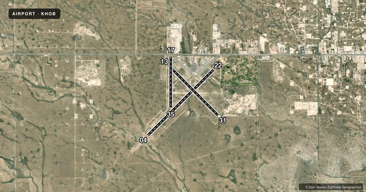
Runways & pattern
Full pagePattern entry · RWY 13
LEFT TRAFFIC| Runway | Heading (°M) | Length | Surface | Traffic |
|---|---|---|---|---|
| 04/22 | 38° / 218° | 8,000 ft | ASPH | Standard L |
| 13/31Favored | 128° / 308° | 6,002 ft | ASPH | Standard L |
| 17/35 | 173° / 353° | 4,370 ft | ASPH | Standard L |
Runway end performance
| End | TORA | TODA | ASDA | LDA | VGSI | Approach lights | Obstruction |
|---|---|---|---|---|---|---|---|
| 04 | 8,000' | 8,000' | 8,000' | 7,398' | — | MALSR | — |
| 22 | 8,000' | 8,000' | 8,000' | 8,000' | PAPI 4-box left(3°) | — | — |
| 13 | 6,002' | 6,002' | 6,002' | 6,002' | PAPI 4-box left(3°) | — | — |
| 31 | 6,002' | 6,002' | 6,002' | 6,002' | PAPI 4-box right(3°) | — | — |
| 17 | 4,370' | 4,370' | 4,370' | 3,878' | — | — | — |
| 35 | 4,370' | 3,418' | 3,878' | 3,878' | — | — | — |
Declared distances in feet. TORA = takeoff run available, TODA = takeoff distance, ASDA = accelerate-stop, LDA = landing distance.
Airport sketch
Runways drawn to scale from FAA survey coordinates, rendered over satellite imagery. Not for navigation.
Approaches & charts
ILS · 1
Services on the field
Fuel grades, oxygen, maintenance, ramp storage and lighting — as declared to the FAA by the airport operator.
Fuel & services
- Fuel
- 100LLA
- Power plant repair
- Minor
- Other services
- AFRT,AMB,CARGO
Ramp & ground
- Transient storage
- Tie-down
- Hangar
- Landing fee
- No fee published
- Customs
- Not available
- Lighting schedule
- SEE RMK
- Beacon schedule
- SS-SR
- Beacon
- White / Green (civil land)(WG)
- Wind indicator
- Lighted
- Segmented circle
- Yes
Fuel & FBOs
Cheapest 100LL and Jet A on the field and nearby. Always confirm with the FBO before taxi.
Airport notes
Surface conditions, obstructions, local procedures, lighting outages and other notes published with each FAA cycle.
General notes
- FOR CD IF UNA TO CTC ON FSS FREQ, CTC FORT WORTH ARTCC AT 817-858-7584.
Lighting notes
- WHEN ATCT CLSD REIL RWY 22; HIRL RWY 04/22; MIRL RWY 13/31 PRESET LOW INTST; TO INCR INTST & ACTVT MALSR RWY 04; PAPI RWY 22, 13, & 31; TWY LGTS - CTAF.
Runway surface & condition
- 04/22PCR VALUE: 410/F/C/X/T
- 13/31PCR VALUE: 200/F/C/X/T
- 17/35PCR VALUE: 80/F/D/X/T
Other notes
- 1FICONS UNMON WHEN UNATNDD.
VFR map & nearby airports
VFR sectional. Tap any ICAO chip to open that airport.
Key facts · KHOB
Answer card- ICAO
- KHOB
- Name
- LEA COUNTY RGNL
- Location
- HOBBS, NEW MEXICO
- Elevation
- 3,660.7 ft MSL
- Traffic pattern altitude
- 4,660.7 ft MSL (1,000 AGL)
- Control tower
- Towered · 0600-1800
- Total runways
- 3
- Longest runway
- 04/22 · 8,000 ft
- Published ILS approaches
- 1
- Published frequencies
- 8
- Magnetic variation
- 7°
- Current flight rules
- VFR
- Current wind
- 120° at 12 kt
- Favored runway now
- RWY 13
LEA County Rgnl (KHOB) sits in Hobbs, New Mexico. The field elevation is 3,660.7 ft MSL. It has three asphalt runways. The longest is runway 04/22 at 8,000 ft. The tower is open 0600-1800. One ILS approach is published for runway 04.
Pattern altitude is not published in the facts. Use the standard 1,000 ft AGL for light piston traffic unless ATC or the current FAA Chart Supplement says otherwise. The airport sits in a high-desert environment, so performance planning matters. Expect density altitude to be a real factor in warm weather. Runway headings are magnetic. Magnetic variation is 7°.
Tailwind Aviation is on the field. It carries 100LL, Jet A and Jet A Prist. Christian Aero is also on the field. It carries 100LL and Jet A Prist. Published remarks say that when the tower is closed, runway lighting and approach lighting are available in a few different configurations. Taxiway lights are controlled by the CTAF. Flight information consoles are unmonitored when unattended. If you need clearance delivery help and cannot reach Flight Service, the Chart Supplement lists Fort Worth ARTCC as the backup contact.
For a first-time arrival, the main things to brief are the elevation, the tower hours, the single ILS to runway 04. Brief the lighting setup after tower close. Check the current FAA Chart Supplement for any changes before you go.