METAR & TAF KGTU
Current METAR
Observed 12:55Z
KGTU 271255Z 19008KT 10SM SCT010 26/23 A3000 RMK AO2 SLP152 T02560233 PNO
- Wind
- 190° @ 8 kt
- Visibility
- 10 SM
- Temp / Dew
- 26°C / 23°C
- Altimeter
- 30.00 inHg
- Clouds
- SCT
- Density alt
- 2,200 ft
- Ceiling
- Unlimited
- Rules
- VFR
Airport info & contacts
Manager on record, flight service, ARTCC, attendance schedule and pattern altitude — published by the FAA and refreshed every 28 days.
Location
- From city
- 3 NM N
- VFR sectional
- SAN ANTONIO
- ARTCC
- ZHU · HOUSTON
- NOTAM facility
- GTU (NOTAM-D)
Airport manager
- Name
- MATTHEW SOMMERFELD
- Phone
- 512-930-8464
- Address
- 500 TERMINAL DRIVE, GEORGETOWN TX 78628
Flight service · Hours
- FSS SJT
- SAN ANGELO1-800-WX-BRIEF
- Attendance
- 0700-1900
Frequencies
Tap any row to copy the frequency to your clipboard.
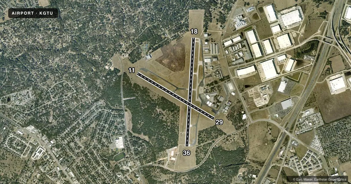
Runways & pattern
Full pagePattern entry · RWY 18
LEFT TRAFFIC| Runway | Heading (°M) | Length | Surface | Traffic |
|---|---|---|---|---|
| 18/36Favored | 178° / 358° | 5,004 ft | ASPH | 36 R |
| 11/29 | 115° / 295° | 4,099 ft | ASPH | 29 R |
Runway end performance
| End | TORA | TODA | ASDA | LDA | VGSI | Approach lights | Obstruction |
|---|---|---|---|---|---|---|---|
| 18 | — | — | — | — | PAPI 4-box left(3°) | — | 35', trees, 445' from thr, 275' R of cntrln, slope 7 |
| 36 | — | — | — | — | PAPI 4-box left(3°) | — | 34', trees, 1170' from thr, 30' R of cntrln, slope 28 |
| 11 | — | — | — | — | — | — | 35', tree, 390' from thr, 270' R of cntrln, slope 5 |
| 29 | — | — | — | — | — | — | 30', tree, 210' from thr, 214' R of cntrln, slope 0 |
Declared distances in feet. TORA = takeoff run available, TODA = takeoff distance, ASDA = accelerate-stop, LDA = landing distance.
Airport sketch
Runways drawn to scale from FAA survey coordinates, rendered over satellite imagery. Not for navigation.
Approaches & charts
Services on the field
Fuel grades, oxygen, maintenance, ramp storage and lighting — as declared to the FAA by the airport operator.
Fuel & services
- Fuel
- 100LLA1+
- Oxygen (bottled)
- HIGH/LOW
- Oxygen (bulk)
- HIGH/LOW
- Airframe repair
- Major
- Power plant repair
- Major
- Other services
- AMB,AVNCS,INSTR,RNTL,SALES
Ramp & ground
- Transient storage
- Tie-down
- Hangar
- Landing fee
- No fee published
- Customs
- Not available
- Lighting schedule
- SEE RMK
- Beacon schedule
- SS-SR
- Beacon
- White / Green (civil land)(WG)
- Wind indicator
- Lighted
- Segmented circle
- Yes
Fuel & FBOs
Cheapest 100LL and Jet A on the field and nearby. Always confirm with the FBO before taxi.
Airport notes
Surface conditions, obstructions, local procedures, lighting outages and other notes published with each FAA cycle.
General notes
- DEER ON & INVOF ARPT.
- MIL HEL OPNS PROHIBITED BTN 2100-0700.
- PTN OF TWY F NOT VISIBLE FM TWR.
- FOR CD CTC AUSTIN APCH AT 512-369-7865.
- RWY 18/36 HEL SKID LDG PROHIBITED TO PREVENT DMG TO GROOVED SFC.
Lighting notes
- AFT TWR HRS, MIRL RWY 18/36 PRESET LOW INTST; TO INCR INTST & ACTVT REILS RWY 18 & 36; MIRL RWY 11/29 - CTAF.
Approach & departure obstructions
- 298 FT FENCE 199 FT DSTC, 246 FT L.
Other notes
- MIL FIELD PRIOR TO 1940.
VFR map & nearby airports
VFR sectional. Tap any ICAO chip to open that airport.
Key facts · KGTU
Answer card- ICAO
- KGTU
- Name
- GEORGETOWN EXEC
- Location
- GEORGETOWN, TEXAS
- Elevation
- 789.5 ft MSL
- Traffic pattern altitude
- 1,789.5 ft MSL (1,000 AGL)
- Control tower
- Towered · 0700-2200
- Total runways
- 2
- Longest runway
- 18/36 · 5,004 ft
- Published ILS approaches
- 0
- Published frequencies
- 9
- Magnetic variation
- 6°
- Current flight rules
- VFR
- Current wind
- 190° at 8 kt
- Favored runway now
- RWY 18
Georgetown Exec sits in Georgetown, Texas. The field elevation is 789.5 ft MSL. It has two asphalt runways. The longest is runway 18/36 at 5,004 ft. The tower is open from 0700 to 2200. No ILS approaches are published here.
For pattern work, the published pattern altitude is not listed. Use the standard 1,000 ft AGL for light piston traffic unless ATC or the current Chart Supplement says otherwise. That puts you at about 1,790 ft MSL based on the field elevation. The airport sits in the Austin area, so expect busy local traffic. Coordinate carefully with tower and Austin Approach when needed. Clearance delivery is handled through Austin Approach.
Cutter Aviation is on the field. It carries 100LL and Jet A. Georgetown Executive Airport Terminal is also on the field. It carries 100LL. A few published remarks matter for planning. A section of taxiway F is not visible from the tower. Helicopter skid landings on runway 18/36 are prohibited because of the grooved surface. After tower hours, runway lighting on 18/36 comes up at a preset low setting. Use CTAF if you need to raise intensity or turn on runway end identifier lights. Deer are reported on and near the airport. Keep a sharp scan on taxi, takeoff and approach.