METAR & TAF KGTR
Current METAR
Observed 15:56Z
KGTR 271556Z VRB05KT 10SM CLR 31/26 A2994 RMK AO2 SLP138 T03110256 $
- Wind
- VAR @ 5 kt
- Visibility
- 10 SM
- Temp / Dew
- 31°C / 26°C
- Altimeter
- 29.94 inHg
- Clouds
- CLR
- Density alt
- 2,223 ft
- Ceiling
- Unlimited
- Rules
- VFR
Airport info & contacts
Manager on record, flight service, ARTCC, attendance schedule and pattern altitude — published by the FAA and refreshed every 28 days.
Location
- From city
- 10 NM W
- VFR sectional
- MEMPHIS
- ARTCC
- ZME · MEMPHIS
- NOTAM facility
- GTR (NOTAM-D)
Airport manager
- Name
- MATTHEW D. DOWELL
- Phone
- 662-327-4422
- Address
- 2080 AIRPORT RD, COLUMBUS MS 39701
Flight service · Hours
- FSS GWO
- GREENWOOD1-800-WX-BRIEF
- Attendance
- ALL
Frequencies
Tap any row to copy the frequency to your clipboard.
Runways & pattern
Full pagePattern entry · RWY 36
LEFT TRAFFICRunway end performance
| End | TORA | TODA | ASDA | LDA | VGSI | Approach lights | Obstruction |
|---|---|---|---|---|---|---|---|
| 18 | — | — | — | — | PAPI 4-box right(3°) | MALSR | — |
| 36 | — | — | — | — | PAPI 4-box left(3°) | — | — |
Declared distances in feet. TORA = takeoff run available, TODA = takeoff distance, ASDA = accelerate-stop, LDA = landing distance.
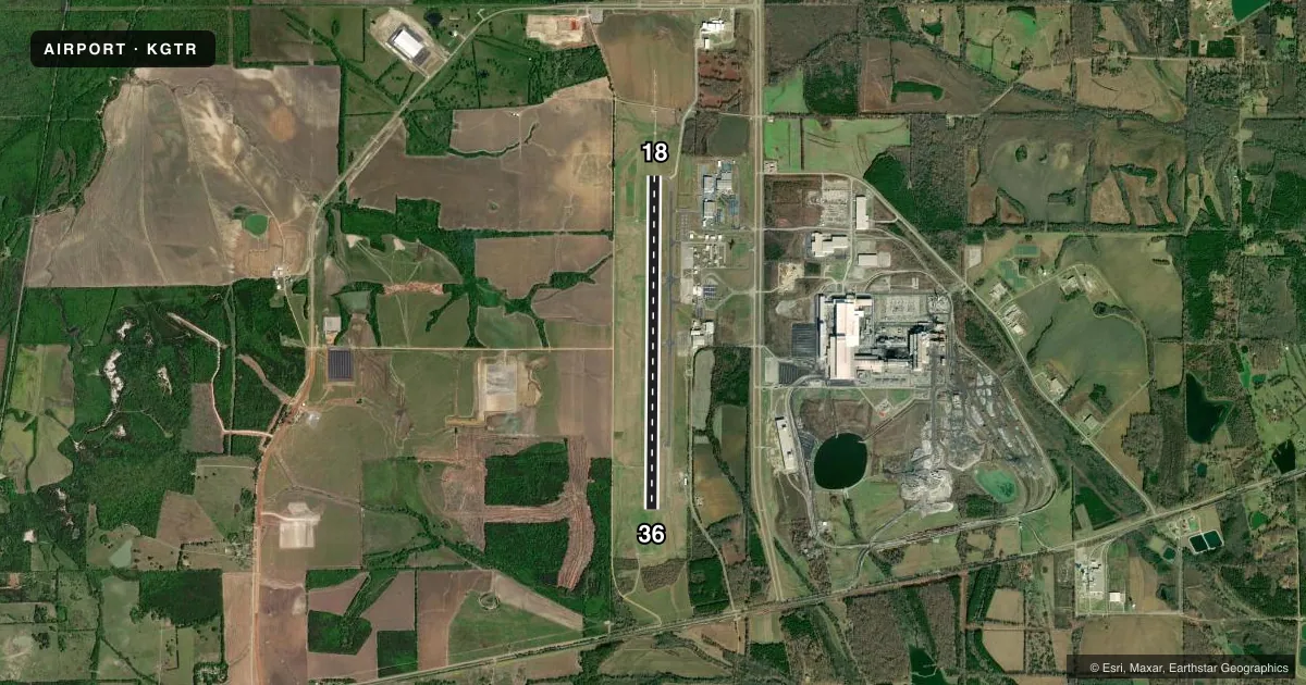
Airport sketch
Runways drawn to scale from FAA survey coordinates, rendered over satellite imagery. Not for navigation.
Approaches & charts
ILS · 2
Services on the field
Fuel grades, oxygen, maintenance, ramp storage and lighting — as declared to the FAA by the airport operator.
Fuel & services
- Fuel
- 100LLAA+
- Airframe repair
- Minor
- Power plant repair
- Minor
- Other services
- CARGO
Ramp & ground
- Transient storage
- Tie-down
- Hangar
- Landing fee
- No fee published
- Customs
- Not available
- Lighting schedule
- SEE RMK
- Beacon schedule
- SS-SR
- Beacon
- White / Green (civil land)(WG)
- Wind indicator
- Lighted
- Segmented circle
- No
Fuel & FBOs
Cheapest 100LL and Jet A on the field and nearby. Always confirm with the FBO before taxi.
Airport notes
Surface conditions, obstructions, local procedures, lighting outages and other notes published with each FAA cycle.
General notes
- BIRDS & WILDLIFE INVOF ARPT.
- ARPT & RWY CONDS NOT MNT 2200-0500.
Lighting notes
- ACTVT MALSR RWY 18; PAPI RWY 18 & 36; HIRL RWY 18/36; TWY LGTS - CTAF.
Fuel notes
- 100LLMIL: HPOX FUEL AVBL.
Runway surface & condition
- 18/36PCR VALUE: 330/F/D/X/T
Other notes
- INDEX B ARFF EQPT AVBL CTC AMGR 662-327-4422.
- MANAGEREXT 201.
VFR map & nearby airports
VFR sectional. Tap any ICAO chip to open that airport.
Key facts · KGTR
Answer card- ICAO
- KGTR
- Name
- GOLDEN TRIANGLE RGNL
- Location
- COLUMBUS/W POINT/STARKVILLE, MISSISSIPPI
- Elevation
- 264 ft MSL
- Traffic pattern altitude
- 1,264 ft MSL (1,000 AGL)
- Control tower
- Towered · 0600-2000
- Total runways
- 1
- Longest runway
- 18/36 · 8,003 ft
- Published ILS approaches
- 2
- Published frequencies
- 12
- Magnetic variation
- 2°
- Current flight rules
- VFR
- Current wind
- 000° at 5 kt
- Favored runway now
- RWY 36
Golden Triangle Rgnl sits near Columbus, West Point and Starkville in Mississippi. Field elevation is 264 ft MSL. The airport has one runway, 18/36, which is 8,003 ft long. The tower is open 0600-2000. Two ILS approaches are published, one for each runway end. Pattern altitude is not published in the facts, so verify the current Chart Supplement before arrival. The field is in a busy regional setup with towered traffic and published approach use. Plan for standard radio work and close attention to sequencing.
Avflight Columbus is the on-field FBO. It carries 100LL and Jet A. The published remarks also note birds and wildlife in the area. Airport and runway conditions are not maintained from 2200 to 0500, so night arrivals deserve extra care. MALSR is active on runway 18. PAPI is available on both runway ends. High intensity runway lights are installed on 18 and 36. Taxiway lights are controlled by CTAF. The runway pavement strength is published as PCN 330/F/D/X/T. Military HPOX fuel is also listed in the remarks. For any current noise, operating, or field condition detail, check the current FAA Chart Supplement or call the airport operator before you go.