METAR & TAF KGOO
Current METAR
Observed 12:15Z
KGOO 271215Z AUTO 00000KT 10SM CLR 20/01 A3005 RMK A01
- Wind
- 000° @ 0 kt
- Visibility
- 10 SM
- Temp / Dew
- 20°C / 1°C
- Altimeter
- 30.05 inHg
- Clouds
- CLR
- Density alt
- 4,354 ft
- Ceiling
- Unlimited
- Rules
- VFR
Airport info & contacts
Manager on record, flight service, ARTCC, attendance schedule and pattern altitude — published by the FAA and refreshed every 28 days.
Location
- From city
- 3 NM E
- VFR sectional
- SAN FRANCISCO
- ARTCC
- ZOA · OAKLAND
- NOTAM facility
- GOO (NOTAM-D)
Airport manager
- Name
- KEVIN EDWARDS
- Phone
- 530-273-3374
- Address
- 13083 JOHN BAUER AVE, GRASS VALLEY CA 95945-9533
Flight service · Hours
- FSS RIU
- RANCHO MURIETA1-800-WX-BRIEF
- Attendance
- 0800-2000
Frequencies
Tap any row to copy the frequency to your clipboard.
Runways & pattern
Full pagePattern entry · RWY 07
LEFT TRAFFICRunway end performance
| End | TORA | TODA | ASDA | LDA | VGSI | Approach lights | Obstruction |
|---|---|---|---|---|---|---|---|
| 07 | — | — | — | — | VASI 4-box left(3°) | — | 20', trees, 612' from thr, 190' R of cntrln, slope 20 |
| 25 | — | — | — | — | — | — | 100', pole, 2600' from thr, 235' R of cntrln, slope 24 |
Declared distances in feet. TORA = takeoff run available, TODA = takeoff distance, ASDA = accelerate-stop, LDA = landing distance.
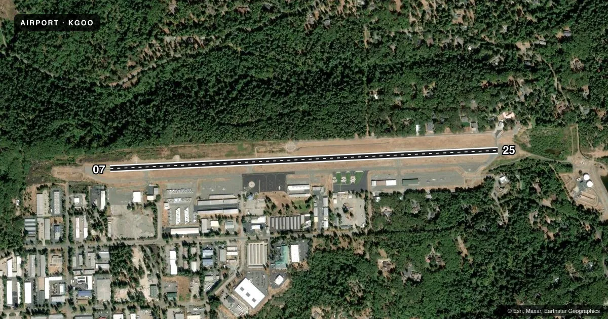
Airport sketch
Runways drawn to scale from FAA survey coordinates, rendered over satellite imagery. Not for navigation.
Approaches & charts
Services on the field
Fuel grades, oxygen, maintenance, ramp storage and lighting — as declared to the FAA by the airport operator.
Fuel & services
- Fuel
- 100LLA
- Oxygen (bottled)
- Not available
- Oxygen (bulk)
- HIGH/LOW
- Airframe repair
- Major
- Power plant repair
- Major
- Other services
- AFRT,CHTR,INSTR,RNTL
Ramp & ground
- Transient storage
- Tie-down
- Landing fee
- No fee published
- Customs
- Not available
- Lighting schedule
- SEE RMK
- Beacon schedule
- SS-SR
- Beacon
- White / Green (civil land)(WG)
- Wind indicator
- Lighted
- Segmented circle
- Yes
Fuel & FBOs
Cheapest 100LL and Jet A on the field and nearby. Always confirm with the FBO before taxi.
Airport notes
Surface conditions, obstructions, local procedures, lighting outages and other notes published with each FAA cycle.
General notes
- RWY 07/25 SLOPES 1.9 PCT DOWNHILL TO THE WEST. RWY 07 TKOFS NOT RCMDD DUE TO RISING TRRN.
- FOR CD CTC NORCAL APCH AT 916-361-6874.
- HELS MAKE STRAIGHT-IN APCHS AND DEPS.
- BE ALERT MAY-OCT FOR CALFIRE AIR TANKER OPS FLYING OVHD PAT FOR RWY 07 (SEE AIM 5-4-27 FOR MNVR AND PHRASEOLOGY). EXPC TANKERS TO DEP RWY 25 AND LAND RWY 07 REGARDLESS OF WIND COND.
Lighting notes
- ACTVT VASI RWY 07; MIRL RWY 07/25 - CTAF.
Other notes
- EXISTED PRIOR TO 1959.
- MANAGERKEVIN.EDWARDS@NEVADACOUNTYCA.GOV
VFR map & nearby airports
VFR sectional. Tap any ICAO chip to open that airport.
Key facts · KGOO
Answer card- ICAO
- KGOO
- Name
- NEVADA COUNTY
- Location
- GRASS VALLEY, CALIFORNIA
- Elevation
- 3,157.7 ft MSL
- Traffic pattern altitude
- 4,157.7 ft MSL (1,000 AGL)
- Control tower
- Non-towered (use CTAF)
- Total runways
- 1
- Longest runway
- 07/25 · 4,657 ft
- Published ILS approaches
- 0
- Published frequencies
- 4
- Magnetic variation
- 16°
- Current flight rules
- VFR
- Current wind
- 000° at 0 kt
- Favored runway now
- –
Nevada County Airport sits in Grass Valley, California. The field elevation is 3,157.7 ft MSL. It has one runway. Runway 07/25 is 4,657 ft long and paved. There is no control tower. No ILS approaches are published.
Pattern altitude is not published. Use the standard 1,000 ft AGL for light piston traffic unless the current Chart Supplement says otherwise. The airport is served by Nevada County Airport on the field. It carries 100LL, Jet A and Jet A Prist. Call (530) 273-3374 for current fuel and ramp details.
The runway slopes 1.9 percent downhill to the west. Takeoffs on Runway 07 are not recommended because of rising terrain. That matters here because the airport sits in the foothills at a higher elevation. Expect density altitude to be a real factor on warm days. CalFire tanker traffic can also affect the pattern from May through October. Tankers may depart Runway 25 and land Runway 07 regardless of wind. Helicopters make straight-in approaches and departures. For clearance delivery, contact NorCal Approach. Use the current Chart Supplement for any noise or curfew restrictions before flying in.