METAR & TAF KGLE
Current METAR
Observed 13:15Z
KGLE 271315Z AUTO 18007KT 10SM CLR 26/21 A2998 RMK AO2 T02600211
- Wind
- 180° @ 7 kt
- Visibility
- 10 SM
- Temp / Dew
- 26°C / 21°C
- Altimeter
- 29.98 inHg
- Clouds
- CLR
- Density alt
- 2,294 ft
- Ceiling
- Unlimited
- Rules
- VFR
Airport info & contacts
Manager on record, flight service, ARTCC, attendance schedule and pattern altitude — published by the FAA and refreshed every 28 days.
Location
- From city
- 3 NM W
- VFR sectional
- DALLAS-FT WORTH
- ARTCC
- ZFW · FORT WORTH
- NOTAM facility
- GLE (NOTAM-D)
Airport manager
- Name
- ANDREW HOLLEY
- Phone
- 940-668-4565
- Address
- 2300 AIRPORT DR, GAINESVILLE TX 76240
Flight service · Hours
- FSS FTW
- FORT WORTH1-800-WX-BRIEF
- Attendance
- 0800-1700
Frequencies
Tap any row to copy the frequency to your clipboard.
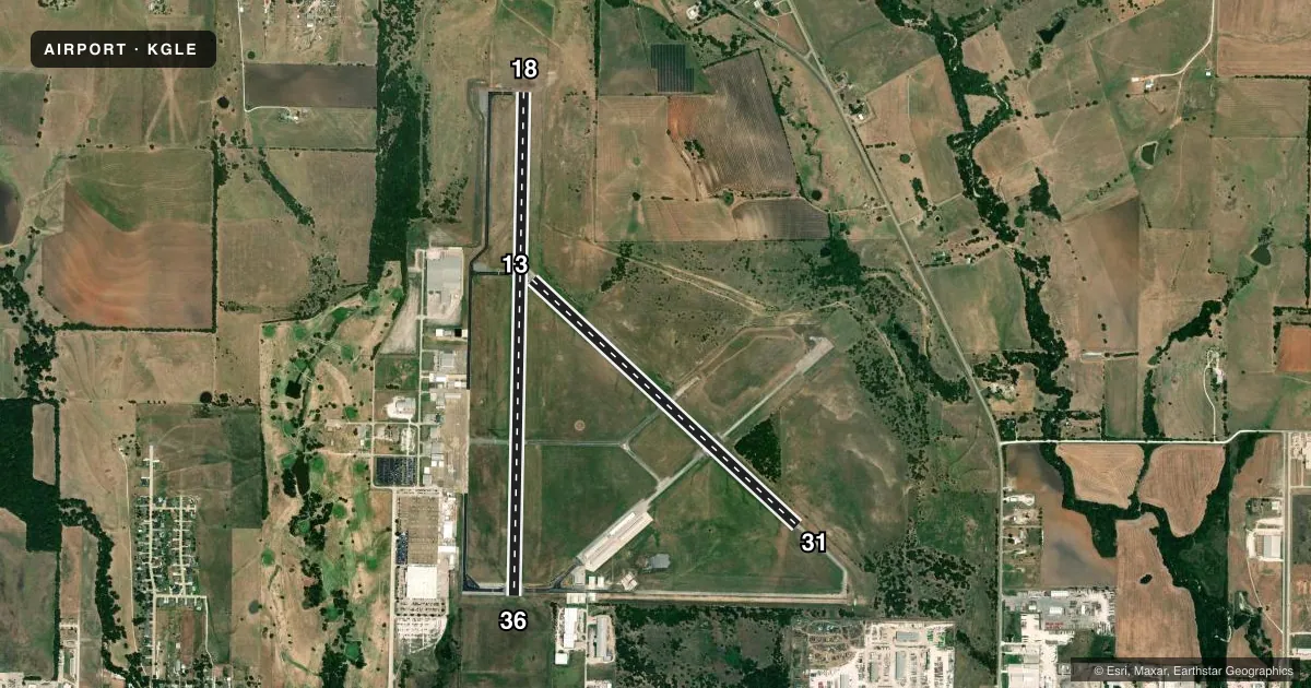
Runways & pattern
Full pagePattern entry · RWY 18
LEFT TRAFFIC| Runway | Heading (°M) | Length | Surface | Traffic |
|---|---|---|---|---|
| 18/36Favored | 178° / 358° | 6,000 ft | ASPH | Standard L |
| 13/31 | 130° / 310° | 4,307 ft | ASPH | Standard L |
Runway end performance
| End | TORA | TODA | ASDA | LDA | VGSI | Approach lights | Obstruction |
|---|---|---|---|---|---|---|---|
| 18 | — | — | — | — | PAPI 2-box right(3°) | — | 45', trees, 1325' from thr, 285' R of cntrln, slope 25 |
| 36 | — | — | — | — | PAPI 2-box left(3°) | — | 35', trees, 1555' from thr, 0' R of cntrln, slope 38 |
| 13 | — | — | — | — | — | — | 70', trees, 1900' from thr, 275' R of cntrln, slope 24 |
| 31 | — | — | — | — | — | — | 22', trees, 650' from thr, 135' R of cntrln, slope 20 |
Declared distances in feet. TORA = takeoff run available, TODA = takeoff distance, ASDA = accelerate-stop, LDA = landing distance.
Airport sketch
Runways drawn to scale from FAA survey coordinates, rendered over satellite imagery. Not for navigation.
Approaches & charts
Services on the field
Fuel grades, oxygen, maintenance, ramp storage and lighting — as declared to the FAA by the airport operator.
Fuel & services
- Fuel
- 100LLA+
- Oxygen (bulk)
- Not available
- Airframe repair
- Major
- Power plant repair
- Major
- Other services
- AGRI,INSTR,RNTL
Ramp & ground
- Transient storage
- Tie-down
- Hangar
- Landing fee
- No fee published
- Customs
- Not available
- Lighting schedule
- SEE RMK
- Beacon schedule
- SS-SR
- Beacon
- White / Green (civil land)(WG)
- Wind indicator
- Lighted
- Segmented circle
- Yes
Fuel & FBOs
Cheapest 100LL and Jet A on the field and nearby. Always confirm with the FBO before taxi.
Airport notes
Surface conditions, obstructions, local procedures, lighting outages and other notes published with each FAA cycle.
General notes
- FOR CD CTC FORT WORTH ARTCC AT 817-858-7584.
- HEL SKID LDG PROHIBITED ON ALL ASPH SFCS.
Lighting notes
- RWY 18/36 MIRL PRESET LOW INTST; TO INCR INTST ACTVT - CTAF.
Fuel notes
- 100LL100LL SELF-SERVE & FULL SERVE.
Approach & departure obstructions
- 13MRKGS FADED.
- 31MRKGS FADED.
- 13RWY HAS AIM POINTS.
- 18ALSO 32 FT PLINE, 1290 FT DSTC, 445 L/R. APCH SLOPE 34:1.
Other notes
- PRE-DATES ACT.
- 13/31EXTSV CRACKING.
VFR map & nearby airports
VFR sectional. Tap any ICAO chip to open that airport.
Key facts · KGLE
Answer card- ICAO
- KGLE
- Name
- GAINESVILLE MUNI
- Location
- GAINESVILLE, TEXAS
- Elevation
- 845.5 ft MSL
- Traffic pattern altitude
- 1,845.5 ft MSL (1,000 AGL)
- Control tower
- Non-towered (use CTAF)
- Total runways
- 2
- Longest runway
- 18/36 · 6,000 ft
- Published ILS approaches
- 0
- Published frequencies
- 2
- Magnetic variation
- 3°
- Current flight rules
- VFR
- Current wind
- 180° at 7 kt
- Favored runway now
- RWY 18
Gainesville Muni is in Gainesville, Texas. Field elevation is 845.5 ft MSL. The airport has two asphalt runways. The longest is 6,000 ft on runway 18/36. There is no control tower. CTAF and UNICOM are both 123.0. No ILS approaches are published here.
Pattern altitude is not published. Use the standard 1,000 ft AGL pattern for light piston traffic unless the current Chart Supplement says otherwise. The on-field FBO is Gainesville Municipal Airport. It carries 100LL and Jet A Prist. Published remarks say 100LL is available self-serve and full serve. Runway 18/36 lights are preset to low intensity. Use the CTAF to increase intensity.
A first-time pilot should pay attention to the runway condition notes. Runway 13/31 has extensive cracking. Markings on runway 13 are faded. Markings on runway 31 are faded. There is also a 32-foot power line near the runway 18 end. Helicopter skid landings are prohibited on all asphalt surfaces. For clearance delivery, contact Fort Worth ARTCC at 817-858-7584. With no tower and no published ILS, plan ahead and verify current procedures before arrival.