METAR & TAF KFWS
Current METAR
Observed 10:35Z
KFWS 271035Z AUTO 21008KT 10SM 25/21 A2994 RMK AO2 T02520212 $
- Wind
- 210° @ 8 kt
- Visibility
- 10 SM
- Temp / Dew
- 25°C / 21°C
- Altimeter
- 29.94 inHg
- Clouds
- Clear
- Density alt
- 2,044 ft
- Ceiling
- Unlimited
- Rules
- VFR
Airport info & contacts
Manager on record, flight service, ARTCC, attendance schedule and pattern altitude — published by the FAA and refreshed every 28 days.
Location
- From city
- 14 NM S
- VFR sectional
- DALLAS-FT WORTH
- ARTCC
- ZFW · FORT WORTH
- NOTAM facility
- FWS (NOTAM-D)
Airport manager
- Name
- JOE HAMMOND
- Phone
- 817-392-5430
- Address
- 450 ALSBURY CT., FORT WORTH TX 76028
Flight service · Hours
- FSS FTW
- FORT WORTH1-800-WX-BRIEF
- Attendance
- 0700-2200
Frequencies
Tap any row to copy the frequency to your clipboard.
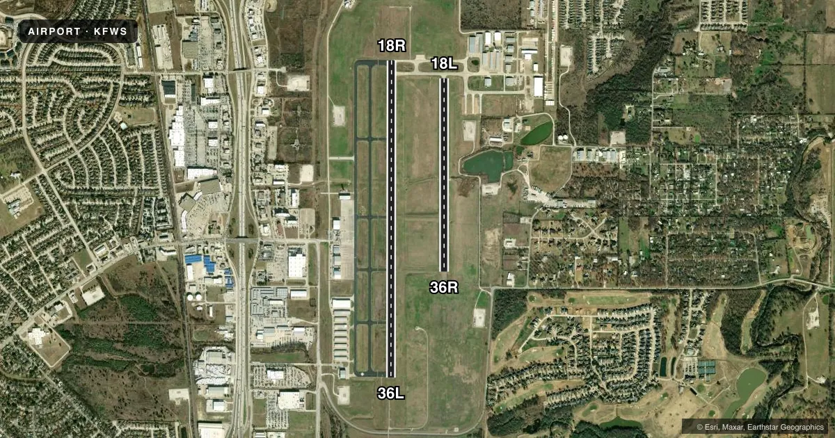
Runways & pattern
Full pagePattern entry · RWY 18R
RIGHT TRAFFIC| Runway | Heading (°M) | Length | Surface | Traffic |
|---|---|---|---|---|
| 18R/36LFavored | 177° / 357° | 6,002 ft | ASPH | 18R R |
| 18L/36R | 177° / 357° | 3,660 ft | TURF | 36R R |
Runway end performance
| End | TORA | TODA | ASDA | LDA | VGSI | Approach lights | Obstruction |
|---|---|---|---|---|---|---|---|
| 18R | — | — | — | — | PAPI 4-box left(3°) | — | 100', pline, 4150' from thr, 0' R of cntrln, slope 39 |
| 36L | — | — | — | — | PAPI 4-box left(3°) | MALSR | 42', trees, 1300' from thr, 280' R of cntrln, slope 26 |
| 36R | — | — | — | — | — | — | 8', gnd, 320' from thr, 0' R of cntrln, slope 40 |
Declared distances in feet. TORA = takeoff run available, TODA = takeoff distance, ASDA = accelerate-stop, LDA = landing distance.
Airport sketch
Runways drawn to scale from FAA survey coordinates, rendered over satellite imagery. Not for navigation.
Approaches & charts
ILS · 1
Services on the field
Fuel grades, oxygen, maintenance, ramp storage and lighting — as declared to the FAA by the airport operator.
Fuel & services
- Fuel
- 100LLA
- Airframe repair
- Major
- Power plant repair
- Major
- Other services
- AVNCS,INSTR,RNTL
Ramp & ground
- Transient storage
- Tie-down
- Hangar
- Lighting schedule
- SEE RMK
- Beacon schedule
- SS-SR
- Beacon
- White / Green (civil land)(WG)
- Wind indicator
- Lighted
- Segmented circle
- Yes
Fuel & FBOs
Cheapest 100LL and Jet A on the field and nearby. Always confirm with the FBO before taxi.
Airport notes
Surface conditions, obstructions, local procedures, lighting outages and other notes published with each FAA cycle.
General notes
- NOISE ABATEMENT PROCEDURE: AVOID NOISE SENSITIVE AREAS ALL QUADRANT OF ARPT; MAINTAIN ALTITUDES AT OR ABOVE 1000 FT AGL OVER THESE AREAS.
- BIRDS & WILDLIFE INVOF ARPT.
- ROTORCRAFT OPNS PROHIBITED IN SELF SVC FUEL AREAS.
- FOR CD WHEN ATCT IS CLSD CTC LONE STAR APCH AT 972-615-2799.
- ROTORCRAFT OPNS PROHIBITED ON TWY A BTN TWY H AND TWY A2.
- HEL SKIDDING OPNS PROHIBITED.
- TWY A UNLIGHTED.
Lighting notes
- ACTVT MALSR RWY 36L - CTAF. WHEN ATCT CLSD MIRL RWY 18R/36L PRESET ON MED INTST.
Fuel notes
- 100LL100LL FULL AND SELF-SERVE.
Runway surface & condition
- 18L/36RAVBL ONLY DURG DALGT/VFR AND DRY WEATHER SFC CONDS.
VFR map & nearby airports
VFR sectional. Tap any ICAO chip to open that airport.
Key facts · KFWS
Answer card- ICAO
- KFWS
- Name
- FORT WORTH SPINKS
- Location
- FORT WORTH, TEXAS
- Elevation
- 700.4 ft MSL
- Traffic pattern altitude
- 1,700.4 ft MSL (1,000 AGL)
- Control tower
- Towered · 0700-2000
- Total runways
- 2
- Longest runway
- 18R/36L · 6,002 ft
- Published ILS approaches
- 1
- Published frequencies
- 7
- Magnetic variation
- 3°
- Current flight rules
- VFR
- Current wind
- 210° at 8 kt
- Favored runway now
- RWY 18R
Fort Worth Spinks is in Fort Worth, Texas. Field elevation is 700.4 ft MSL. The airport has two runways. The longest is 18R/36L at 6,002 ft. The other runway is 18L/36R at 3,660 ft turf. The tower is open 0700-2000. One ILS is published for runway 36L.
Pattern altitude is not published. Use 1,000 ft AGL for light piston traffic unless ATC or local procedures say otherwise. Vesper Aviation is on the field. It carries 100LL, Jet A and Jet A Prist. 100LL is available in full service. 100LL is also available self-service. Helicopter skidding operations are prohibited. Rotorcraft are also prohibited in the self-service fuel area. Runway 18L/36R is daylight VFR only. It also requires a dry surface.
Noise abatement matters here. Avoid noise sensitive areas in all quadrants of the airport. Stay at or above 1,000 ft AGL over those areas. Birds and wildlife are reported in the area. Taxiway A is unlighted. When the tower is closed, runway 18R/36L lights are preset to medium intensity. Use the CTAF to activate the MALSR for runway 36L. For clearance delivery after tower hours, contact Lone Star Approach. This is a busy metro field. Plan for controlled airspace work. Keep a close eye on runway and taxiway lighting before you go.