METAR & TAF KFPR
Current METAR
Observed 17:53Z
KFPR 271753Z 25007KT 10SM SCT039 BKN050 33/25 A2990 RMK AO2 SLP124 T03280250 10339 20244 58011
- Wind
- 250° @ 7 kt
- Visibility
- 10 SM
- Temp / Dew
- 33°C / 25°C
- Altimeter
- 29.90 inHg
- Clouds
- BKN
- Density alt
- 2,214 ft
- Ceiling
- 5,000 ft AGL
- Rules
- VFR
Airport info & contacts
Manager on record, flight service, ARTCC, attendance schedule and pattern altitude — published by the FAA and refreshed every 28 days.
Location
- From city
- 3 NM NW
- VFR sectional
- MIAMI
- ARTCC
- ZMA · MIAMI
- NOTAM facility
- FPR (NOTAM-D)
Airport manager
- Name
- CAMERON HOWARD
- Phone
- 772-462-1727
- Address
- 3000 CURTIS KING BOULEVARD, FT PIERCE FL 34946
Flight service · Hours
- FSS MIA
- MIAMI1-800-WX-BRIEF
- Attendance
- 0700-2100
Frequencies
Tap any row to copy the frequency to your clipboard.
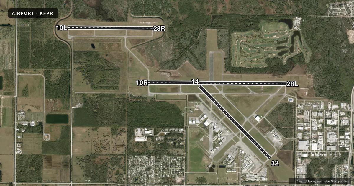
Runways & pattern
Full pagePattern entry · RWY 28L
LEFT TRAFFIC| Runway | Heading (°M) | Length | Surface | Traffic |
|---|---|---|---|---|
| 10R/28LFavored | 83° / 263° | 6,492 ft | ASPH | 10R R |
| 14/32 | 128° / 308° | 4,755 ft | ASPH | 14 R |
| 10L/28R | 83° / 263° | 4,000 ft | ASPH | 28R R |
Runway end performance
| End | TORA | TODA | ASDA | LDA | VGSI | Approach lights | Obstruction |
|---|---|---|---|---|---|---|---|
| 10R | 6,492' | 6,492' | 6,483' | 6,483' | PAPI 4-box left(3°) | — | 26', trees, 1380' from thr, 555' R of cntrln, slope 45 |
| 28L | 6,492' | 6,492' | 6,434' | 6,434' | PAPI 4-box left(3°) | — | 35', trees, 1160' from thr, 400' R of cntrln, slope 27 |
| 14 | — | — | — | — | PAPI 4-box left(3°) | — | 32', trees, 1335' from thr, 260' R of cntrln, slope 35 |
| 32 | — | — | — | — | — | — | 43', trees, 1690' from thr, 220' R of cntrln, slope 34 |
| 10L | — | — | — | — | — | — | 78', pline, 1765' from thr, 0' R of cntrln, slope 20 |
| 28R | — | — | — | — | — | — | 40', trees, 840' from thr, 105' R of cntrln, slope 16 |
Declared distances in feet. TORA = takeoff run available, TODA = takeoff distance, ASDA = accelerate-stop, LDA = landing distance.
Airport sketch
Runways drawn to scale from FAA survey coordinates, rendered over satellite imagery. Not for navigation.
Approaches & charts
ILS · 1
Services on the field
Fuel grades, oxygen, maintenance, ramp storage and lighting — as declared to the FAA by the airport operator.
Fuel & services
- Fuel
- 100LLA
- Oxygen (bottled)
- Not available
- Oxygen (bulk)
- HIGH/LOW
- Airframe repair
- Major
- Power plant repair
- Major
- Other services
- AMB,AVNCS,CHTR,INSTR,RNTL,SALES
Ramp & ground
- Transient storage
- Tie-down
- Hangar
- Landing fee
- No fee published
- Customs
- Not available
- Lighting schedule
- SEE RMK
- Beacon schedule
- SS-SR
- Beacon
- White / Green (civil land)(WG)
- Wind indicator
- Lighted
Fuel & FBOs
Cheapest 100LL and Jet A on the field and nearby. Always confirm with the FBO before taxi.
Airport notes
Surface conditions, obstructions, local procedures, lighting outages and other notes published with each FAA cycle.
General notes
- EXTENSIVE FLIGHT TRAINING ON AND WITHIN 20 MILES OF ARPT BLO 6000 FT. VFR TRAINING ACFT OUTSIDE OF CLASS D AIRSPACE TRANSMIT INTENDED ACTIVITY ON 123.3.
- NUMEROUS FLOCKS OF BIRDS & WILDLIFE ON AND INVOF ARPT.
- TWY C1 RESTRICTED TO ACFT WITH A WING SPAN OF 105 FT OR LESS.
- 8 FT FENCE 400 FT FM CNTRLN ON NORTH SIDE OF RWY 10R/28L AND EAST OF RWY 14/32.
- VOLUNTARY NOISE ABATEMENT PROCS IN EFCT, CTC ARPT MGMT AT 772-462-1732.
- LGTD ARFF COM ANT 125 FT AGL (149 FT AMSL) LCTD 793 FT SSE OF RWY 27 THLD.
- RWY 10L/28R VFR TRNG RWY.
- HIGH TENSION PLINES 1/4 SM 'W' AER 10L UNMKD & UNLIGHTED.
- DRAINAGE CHANNEL 80 FT WIDE, 10 FT DEEP, 600 FT FM AER 10L.
- DRAINAGE CHANNEL 80 FT WIDE, 10 FT DEEP 530 FT AER 28R. 2 FT DRAINAGE DITCH 361 FT FR RY 10R THLD 259 FT RIGHT.
- 2 FT DRAINAGE DITCH 797 FT FM THR RWY 28L 349 FT LEFT.
- 2 FT DRAINAGE DITCH 367 FT 'W' OF TWY 'A1' BTWN TWY 'A' & RWY 10L/28R.
- FOR CD, IF UNA VIA GCO, CTC PALM BEACH APCH AT 561-684-9047 OR 561-275-1430.
- GCO AVBL ON FREQ 119.55 PALM BEACH CD.
Lighting notes
- ACTVT REIL RWY 10R & 28L; MIRL RWY 10L/28R, 10R/28L & 14/32 - CTAF.
Fuel notes
- 100LL100LL SELF SERVE
Runway surface & condition
- 10L/28RPCR VALUE: 130/F/A/Y/T
- 10R/28LPCR VALUE: 310/F/A/X/T
- 14/32PCR VALUE: 620/F/A/X/T
- 10R/28L25' PAVED SHOULDERS.
- 14/3250' PAVED SHOULDERS.
Approach & departure obstructions
- 10RRWY 10R APCH SLP 50:1 TO AER.
- 28LRWY 28L APCH SLP 34:1 TO AER.
- 28RRWY 28R APCH SLP 21:1 TO AER.
Other notes
- THIS AIRPORT HAS BEEN SURVEYED BY THE NATIONAL GEODETIC SURVEY.
VFR map & nearby airports
VFR sectional. Tap any ICAO chip to open that airport.
Key facts · KFPR
Answer card- ICAO
- KFPR
- Name
- TREASURE COAST INTL
- Location
- FORT PIERCE, FLORIDA
- Elevation
- 23.4 ft MSL
- Traffic pattern altitude
- 1,023.4 ft MSL (1,000 AGL)
- Control tower
- Towered · 0700-2100
- Total runways
- 3
- Longest runway
- 10R/28L · 6,492 ft
- Published ILS approaches
- 1
- Published frequencies
- 5
- Magnetic variation
- 7°
- Current flight rules
- VFR
- Current wind
- 250° at 7 kt
- Favored runway now
- RWY 28L
Treasure Coast Intl is in Fort Pierce, Florida. Field elevation is 23.4 ft MSL. The airport has three asphalt runways. The longest is 10R/28L at 6,492 ft. The field is towered from 0700 to 2100. One ILS is published for runway 10R. Pattern altitude is not published, so plan on the standard 1,000 ft AGL for light piston traffic unless the current Chart Supplement says otherwise.
APP Jet Center is on the field. It carries 100LL and Jet A. 100LL self-serve fuel is available. The airport sees a lot of flight training. Expect traffic in the pattern and in the area below 6,000 ft. Voluntary noise abatement procedures are in effect. Contact airport management for current guidance before you go.
There are a few items worth having in mind on arrival. Birds and wildlife are reported on and near the airport. Runway 28L has a published approach slope note. Runway 10R/28L has runway end identifier lights. Medium intensity runway lights are on 10L/28R, 10R/28L and 14/32. Use CTAF when appropriate. Check the current FAA Chart Supplement for any published noise or curfew restrictions before flying into the field.