METAR & TAF KFOD
Current METAR
Observed 21:56Z
KFOD 272156Z AUTO 32004KT 10SM CLR 33/22 A2979 RMK AO2 SLP087 T03280222 $
- Wind
- 320° @ 4 kt
- Visibility
- 10 SM
- Temp / Dew
- 33°C / 22°C
- Altimeter
- 29.79 inHg
- Clouds
- CLR
- Density alt
- 3,755 ft
- Ceiling
- Unlimited
- Rules
- VFR
Airport info & contacts
Manager on record, flight service, ARTCC, attendance schedule and pattern altitude — published by the FAA and refreshed every 28 days.
Location
- From city
- 3 NM N
- VFR sectional
- OMAHA
- Pattern altitude
- 843 ft AGL · 1,999 ft MSL
- ARTCC
- ZMP · MINNEAPOLIS
- NOTAM facility
- FOD (NOTAM-D)
Airport manager
- Name
- MRS. SARAH RUSTVOLD
- Phone
- 515-573-3881
- Address
- 1639 NELSON AVE SUITE 2, FORT DODGE IA 50501
Flight service · Hours
- FSS FOD
- FORT DODGE1-800-WX-BRIEF
- Attendance
- 0500-1600
Frequencies
Tap any row to copy the frequency to your clipboard.
Runways & pattern
Full pagePattern entry · RWY 30
LEFT TRAFFIC| Runway | Heading (°M) | Length | Surface | Traffic |
|---|---|---|---|---|
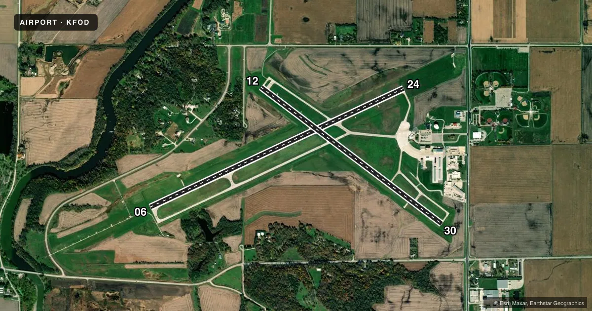
| 06/24 | 63° / 243° | 6,547 ft | ASPH | Standard L |
| 12/30Favored | 125° / 305° | 5,301 ft | ASPH | Standard L |
Runway end performance
| End | TORA | TODA | ASDA | LDA | VGSI | Approach lights | Obstruction |
|---|---|---|---|---|---|---|---|
| 06 | 6,547' | 6,547' | 6,547' | 6,547' | PAPI 4-box left(3°) | MALSR | — |
| 24 | 6,547' | 6,547' | 6,547' | 6,547' | VASI 4-box left(3°) | — | — |
| 12 | 5,301' | 5,301' | 5,301' | 5,301' | VASI 4-box left(3°) | — | — |
| 30 | 5,301' | 5,301' | 5,301' | 5,301' | PAPI 4-box left(3°) | — | 30', pole, 1340' from thr, 224' R of cntrln, slope 38 |
Declared distances in feet. TORA = takeoff run available, TODA = takeoff distance, ASDA = accelerate-stop, LDA = landing distance.
Airport sketch
Runways drawn to scale from FAA survey coordinates, rendered over satellite imagery. Not for navigation.
Approaches & charts
ILS · 1
Services on the field
Fuel grades, oxygen, maintenance, ramp storage and lighting — as declared to the FAA by the airport operator.
Fuel & services
- Fuel
- 100LLA
- Oxygen (bottled)
- Not available
- Oxygen (bulk)
- Not available
- Airframe repair
- Major
- Power plant repair
- Major
- Other services
- AFRT,AMB,AVNCS,CHTR,INSTR,RNTL
Ramp & ground
- Transient storage
- Tie-down
- Hangar
- Landing fee
- No fee published
- Customs
- Not available
- Lighting schedule
- SEE RMK
- Beacon schedule
- SS-SR
- Beacon
- White / Green (civil land)(WG)
- Wind indicator
- Lighted
- Segmented circle
- No
Fuel & FBOs
Cheapest 100LL and Jet A on the field and nearby. Always confirm with the FBO before taxi.
Airport notes
Surface conditions, obstructions, local procedures, lighting outages and other notes published with each FAA cycle.
General notes
- ACR OPNS INVOLVING ACFT WITH MORE THAN 9 PASSENGER SEATS ARE NOT AUTHORIZED IN EXCESS OF 15 MINS BEFORE OR AFT SCHEDULED ARR OR DEP TIMES WITHOUT PRIOR COORD WITH ARPT MANAGEMENT AND/OR ARPT MAINT & CONFIRMATION THAT ARFF SVCS ARE AVBL PRIOR TO LANDING OR TAKEOFF.
- RY 06 IS CALM WIND RY.
- SFC CONDS NOT MONTRD ON WKENDS AND BTWN 1600-0500 MON-FRI.
- FOR CD IF UNA TO CTC ON FSS FREQ, CTC MINNEAPOLIS ARTCC AT 651-463-5588.
Lighting notes
- ACTVT HIRL RY 06/24; MIRL RY 12/30; REIL RYS 12, 24 & 30; MALSR RY 06 & VASI RYS 12 & 24 & PAPI RYS 06 & 30 - CTAF.
Fuel notes
- 100LL100LL AND JET A SELF-SVC FUEL AVBL.
Runway surface & condition
- 06/24PCR VALUE: 610/F/C/X/T
- 12/30PCR VALUE: 180/R/C/W/T
Other notes
- ARFF INDEX B AVBL PPR CTC ARPT OPS 712-541-5790.
- 1FOR ATTENDANT AFT HRS CALL (515) 955-3434/570-6206
- MANAGEREMAIL ADDRESS: SRUSTVOLD@FORTDODGEIOWA.ORG (ALL LOWER CASE)
VFR map & nearby airports
VFR sectional. Tap any ICAO chip to open that airport.
Key facts · KFOD
Answer card- ICAO
- KFOD
- Name
- FORT DODGE RGNL
- Location
- FORT DODGE, IOWA
- Elevation
- 1,156.3 ft MSL
- Traffic pattern altitude
- 1,999.3 ft MSL (843 AGL)
- Control tower
- Non-towered (use CTAF)
- Total runways
- 2
- Longest runway
- 06/24 · 6,547 ft
- Published ILS approaches
- 1
- Published frequencies
- 2
- Magnetic variation
- 2°
- Current flight rules
- VFR
- Current wind
- 320° at 4 kt
- Favored runway now
- RWY 30
Fort Dodge Rgnl sits in Fort Dodge, Iowa. Field elevation is 1,156.3 ft MSL. The airport has two asphalt runways. The longest is runway 06/24 at 6,547 ft. This is an uncontrolled field. CTAF and UNICOM are both 123.0. Runway 06 has the ILS. The pattern altitude is 843 ft AGL, which is 1,999.3 ft MSL.
Fort Dodge Flight Support is on the field. It carries 100LL and Jet A. Self-serve fuel is available. Runway 06/24 has high intensity lighting. Runway 12/30 has medium intensity lighting. Runway end identifier lights are on 12, 24 and 30. PAPI is on 06 and 30. VASI is on 12 and 24. The published remarks also say runway 06 is the calm wind runway.
For a first-time arrival, plan for a non-towered pattern and use the common traffic advisory frequency. The airport has one ILS approach, so runway 06 is the instrument option to study first. Surface conditions are not monitored on weekends or between 1600 and 0500 Monday through Friday. If you need clearance delivery and cannot reach flight service, Minneapolis ARTCC is listed for contact. Aircraft with more than 9 passenger seats need prior coordination before arrival or departure.