METAR & TAF KENV
Current METAR
Observed 15:56Z
KENV 271556Z AUTO 30015KT 6SM HZ CLR 30/02 A3004 RMK AO2 SLP114 T03000017
- Wind
- 300° @ 15 kt
- Visibility
- 6 SM
- Temp / Dew
- 30°C / 2°C
- Altimeter
- 30.04 inHg
- Clouds
- CLR
- Density alt
- 6,905 ft
- Ceiling
- Unlimited
- Rules
- VFR
Airport info & contacts
Manager on record, flight service, ARTCC, attendance schedule and pattern altitude — published by the FAA and refreshed every 28 days.
Location
- From city
- 1 NM SE
- VFR sectional
- SALT LAKE CITY
- ARTCC
- ZLC · SALT LAKE CITY
- NOTAM facility
- ENV (NOTAM-D)
Airport manager
- Name
- LISA DUNN
- Phone
- 435-843-3360
- Address
- P.O. BOX 159, WENDOVER UT 84083
Flight service · Hours
- FSS CDC
- CEDAR CITY1-800-WX-BRIEF
- Attendance
- 0800-1800
Frequencies
Tap any row to copy the frequency to your clipboard.
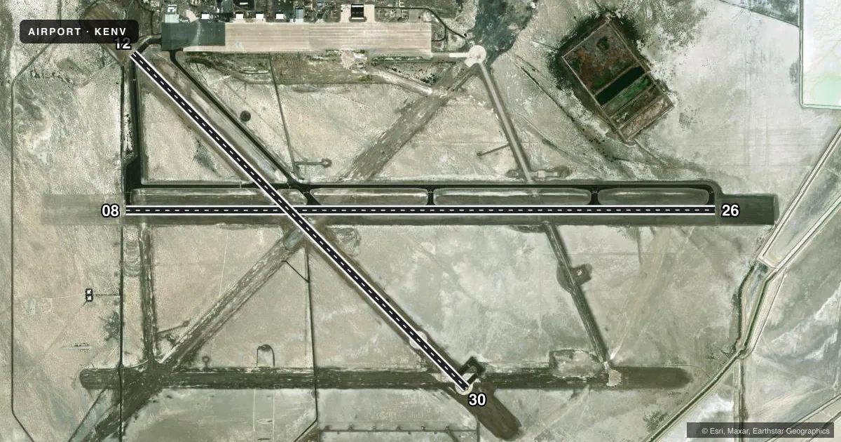
Runways & pattern
Full pagePattern entry · RWY 30
LEFT TRAFFIC| Runway | Heading (°M) | Length | Surface | Traffic |
|---|---|---|---|---|
| 08/26 | 78° / 258° | 10,002 ft | ASPH | 08 R |
| 12/30Favored | 123° / 303° | 8,002 ft | ASPH | 12 R |
Runway end performance
| End | TORA | TODA | ASDA | LDA | VGSI | Approach lights | Obstruction |
|---|---|---|---|---|---|---|---|
| 08 | 10,002' | 10,002' | 10,002' | 10,002' | PAPI 4-box left(3°) | — | — |
| 26 | 10,002' | 10,002' | 10,002' | 10,002' | PAPI 4-box left(3°) | — | — |
| 12 | 8,002' | 8,002' | 8,002' | 8,002' | — | — | — |
| 30 | 8,002' | 8,002' | 8,002' | 8,002' | PAPI 4-box left(3°) | — | — |
Declared distances in feet. TORA = takeoff run available, TODA = takeoff distance, ASDA = accelerate-stop, LDA = landing distance.
Airport sketch
Runways drawn to scale from FAA survey coordinates, rendered over satellite imagery. Not for navigation.
Approaches & charts
Services on the field
Fuel grades, oxygen, maintenance, ramp storage and lighting — as declared to the FAA by the airport operator.
Fuel & services
- Fuel
- 100A
- Airframe repair
- Minor
- Power plant repair
- Minor
Ramp & ground
- Transient storage
- Hangar
- Landing fee
- No fee published
- Customs
- Not available
- Lighting schedule
- SEE RMK
- Beacon schedule
- SS-SR
- Beacon
- White / Green (civil land)(WG)
- Wind indicator
- Yes
- Segmented circle
- Yes
Fuel & FBOs
Cheapest 100LL and Jet A on the field and nearby. Always confirm with the FBO before taxi.
Airport notes
Surface conditions, obstructions, local procedures, lighting outages and other notes published with each FAA cycle.
General notes
- COLD TEMPERATURE AIRPORT. ALTITUDE CORRECTION REQUIRED AT OR BELOW -12C.
- ALL SFCS AVBL TO ACRS.
Lighting notes
- ACTVT REIL RWY 08, 12, 26, 30; PAPI RWY 08, 26, 30; MIRL RWY 08/26 & 12/30 - CTAF.
Runway surface & condition
- 08/26PCR VALUE: 490/F/D/X/T
- 12/30PCR VALUE: 560/F/D/X/T
Other notes
- EXISTED PRIOR TO 1959.
- 24 HR PPR FOR ACFT OPNS WITH MORE THAN 30 PAX CALL AMGR 775-778-1891 OR 801-520-1613. WHEN REQD ARPT WILL MNTN ARFF INDEX B.
VFR map & nearby airports
VFR sectional. Tap any ICAO chip to open that airport.
Key facts · KENV
Answer card- ICAO
- KENV
- Name
- WENDOVER
- Location
- WENDOVER, UTAH
- Elevation
- 4,236.7 ft MSL
- Traffic pattern altitude
- 5,236.7 ft MSL (1,000 AGL)
- Control tower
- Non-towered (use CTAF)
- Total runways
- 2
- Longest runway
- 08/26 · 10,002 ft
- Published ILS approaches
- 0
- Published frequencies
- 2
- Magnetic variation
- 12°
- Current flight rules
- VFR
- Current wind
- 300° at 15 kt
- Favored runway now
- RWY 30
Wendover Airport sits in Wendover, Utah. Field elevation is 4,236.7 ft MSL. The airport has two asphalt runways. The longest is 10,002 ft on 08/26. Runway 12/30 is 8,002 ft. This is an uncontrolled field. CTAF and UNICOM are both 122.8.
No ILS approaches are published here. Runway end identifier lights are installed on 08, 12, 26 and 30. PAPI is available on 08, 26 and 30. Medium intensity runway lights are installed on both runways. The published pattern altitude is not listed, so use the standard 1,000 ft AGL for light piston operations unless the current FAA Chart Supplement says otherwise. That puts the common pattern at about 5,237 ft MSL.
Wendover Airport has one on-field FBO. Wendover Airport carries 100LL, Jet A and Jet A Prist. The field is old. It existed before 1959. It is also a cold temperature airport. Altitude correction is required at or below minus 12 degrees Celsius. For larger aircraft, note the published prior permission requirement for operations with more than 30 passengers. Check with the airport manager before arrival if that applies to your flight.