METAR & TAF KEGE
Current METAR
Observed 07:56Z
KEGE 280756Z AUTO 15003KT 10SM CLR 19/12 A3024 RMK AO2 SLP135 T01940122
- Wind
- 150° @ 3 kt
- Visibility
- 10 SM
- Temp / Dew
- 19°C / 12°C
- Altimeter
- 30.24 inHg
- Clouds
- CLR
- Density alt
- 8,202 ft
- Ceiling
- Unlimited
- Rules
- VFR
Airport info & contacts
Manager on record, flight service, ARTCC, attendance schedule and pattern altitude — published by the FAA and refreshed every 28 days.
Location
- From city
- 4 NM W
- VFR sectional
- DENVER
- ARTCC
- ZDV · DENVER
- NOTAM facility
- EGE (NOTAM-D)
Airport manager
- Name
- DAVID REID
- Phone
- (970) 328-2680
- Address
- 219 ELDON WILSON ROAD, GYPSUM CO 81637
Flight service · Hours
- FSS DEN
- DENVER1-800-WX-BRIEF
- Attendance
- 0600-2100
Frequencies
Tap any row to copy the frequency to your clipboard.
Runways & pattern
Full pagePattern entry · RWY 07
RIGHT TRAFFICRunway end performance
| End | TORA | TODA | ASDA | LDA | VGSI | Approach lights | Obstruction |
|---|---|---|---|---|---|---|---|
| 07 | 9,000' | 9,000' | 9,000' | 9,000' | — | — | 503', tree, 10000' from thr, 825' R of cntrln, slope 19 |
| 25 | 9,000' | 9,000' | 9,000' | 8,000' | PAPI 4-box right(3°) | MALSR | — |
Declared distances in feet. TORA = takeoff run available, TODA = takeoff distance, ASDA = accelerate-stop, LDA = landing distance.
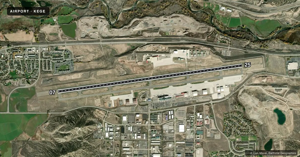
Airport sketch
Runways drawn to scale from FAA survey coordinates, rendered over satellite imagery. Not for navigation.
Approaches & charts
ILS · 2
Services on the field
Fuel grades, oxygen, maintenance, ramp storage and lighting — as declared to the FAA by the airport operator.
Fuel & services
- Fuel
- 100LLA1A1+MOGAS
- Oxygen (bottled)
- High pressure
- Oxygen (bulk)
- High pressure
- Airframe repair
- Major
- Power plant repair
- Major
- Other services
- AFRT,AMB,CHTR,INSTR,RNTL,SALES
Ramp & ground
- Transient storage
- Tie-down
- Hangar
- Landing fee
- Yes
- Customs
- Not available
- Lighting schedule
- SEE RMK
- Beacon schedule
- SS-SR
- Beacon
- White / Green (civil land)(WG)
- Wind indicator
- Lighted
- Segmented circle
- Yes
Fuel & FBOs
Cheapest 100LL and Jet A on the field and nearby. Always confirm with the FBO before taxi.
Airport notes
Surface conditions, obstructions, local procedures, lighting outages and other notes published with each FAA cycle.
General notes
- NO SNOW REMOVAL OR RWY MONITORING NOV-APR 0600-1300Z.
- EXTENSIVE MILITARY HELICOPTER TRAINING OPERATIONS SURFACE TO 1000 FT AGL WITHIN 25 NM RADIUS EAGLE COUNTY AIRPORT 0630-2200.
- HI UNMKD TERRAIN ALL QUADS. NGT OPNS DISCOURAGED TO PILOTS UNFAM WITH ARPT.
- RECOMMEND ALL ACFT DEPT RWY 25 INITIATE A LEFT TURN AS SOON AS ALTITUDE & SAFETY PERMIT TO AVOID HIGH TERRAIN.
- MTN TOP 10:1 CLNC 13000 FT FM THR, 1500 FT LEFT OF RWY CNTRLN EXTENDED.
- ACRS SHOULD NOT LVE OR ENTER TWY A FM RAMP EAST OF TWY C-2.
- CRITICAL ACFT ARE CAT D IV, B757-200 EQUIVALENT AND LOWER.
- FOR ATCT HRS CONTACT ARFF AT 970-328-2688.
- COLD TEMPERATURE AIRPORT. ALTITUDE CORRECTION REQUIRED AT OR BELOW -19C.
- FOR CD CTC EAGLE ATCT AT 970-524-0803, WHEN ATCT CLSD CTC DENVER ARTCC AT 303-651-4257.
Lighting notes
- WHEN ATCT CLSD ACTVT MALSR RWY 25; REIL RWY 07; HIRL RWY 07/25 - CTAF. PAPI RWY 25 OPR CONSLY.
Runway surface & condition
- 07/252S 175
- 07/25PCR VALUE: 464/F/B/X/T
- 25XTHIS RWY EXISTS TO SUPPORT (VAZ) LDA/DME ASSOCIATED WITH RWY 25.
Other notes
- UNSKED ACR OPNS WITH MORE THAN 30 PSGR SEATS CALL ARPT FIRE DEPT 970-328-2688.
- LNDG FEE OF $3.00 PER THOUSAND POUNDS FOR GA ACFT >12,500 LBS.
- REGULAR OFFICE HOURS: THU-MON 0900-1700. AFTER HRS SVC AVBL: OFFICE 970-524-0490. AFTER HRS 303-472-1125. THREE HR ADVANCE NOTICE REQUIRED.
VFR map & nearby airports
VFR sectional. Tap any ICAO chip to open that airport.
Key facts · KEGE
Answer card- ICAO
- KEGE
- Name
- EAGLE COUNTY RGNL
- Location
- EAGLE, COLORADO
- Elevation
- 6,547.4 ft MSL
- Traffic pattern altitude
- 7,547.4 ft MSL (1,000 AGL)
- Control tower
- Towered · 0700-1900 HRS.
- Total runways
- 1
- Longest runway
- 07/25 · 9,000 ft
- Published ILS approaches
- 2
- Published frequencies
- 6
- Magnetic variation
- 9°
- Current flight rules
- VFR
- Current wind
- 150° at 3 kt
- Favored runway now
- RWY 07
Eagle County Rgnl sits in Eagle, Colorado. The field elevation is 6,547.4 ft MSL. It has one runway, 07/25, which is 9,000 ft long. The airport is towered. Tower hours are 0700-1900 HRS. Two ILS approaches are published. Runway 25X also exists to support the VAZ LDA/DME associated with runway 25.
Pattern altitude is not published. Use the standard 1,000 ft AGL for light piston traffic unless the current FAA Chart Supplement says otherwise. Signature Aviation is on the field. It carries 100LL, Jet A and Jet A Prist. The airport is in mountain terrain. High unmarked terrain surrounds the field in all quadrants. Night operations are discouraged for pilots who are not familiar with the airport.
There are a few operational items to plan around. Extensive military helicopter training occurs within 25 NM from the surface to 1,000 ft AGL between 0630 and 2200. Runway 25 departures are recommended to start a left turn as soon as altitude and safety permit to stay clear of terrain. The field is also a cold temperature airport. Altitude correction is required at or below minus 19 C. For tower hours and clearance issues, use the published airport contacts in the Chart Supplement or call the airport directly.