METAR & TAF KECG
Current METAR
Observed 17:19Z
KECG 271719Z 19005KT 10SM VCTS -RA SCT021 OVC095 25/23 A2986 RMK AO2 LTG DSNT NW-NE P0000 T02500228
- Wind
- 190° @ 5 kt
- Visibility
- 10 SM
- Temp / Dew
- 25°C / 23°C
- Altimeter
- 29.86 inHg
- Clouds
- OVC
- Density alt
- 1,288 ft
- Ceiling
- 9,500 ft AGL
- Rules
- VFR
Airport info & contacts
Manager on record, flight service, ARTCC, attendance schedule and pattern altitude — published by the FAA and refreshed every 28 days.
Location
- From city
- 3 NM SE
- VFR sectional
- WASHINGTON
- ARTCC
- ZDC · WASHINGTON
- NOTAM facility
- ECG (NOTAM-D)
Airport manager
- Name
- ROBERT POPP, CIV USCG
- Phone
- 719-505-6367
- Address
- 1664 WEEKSVILLE RD, ELIZABETH CITY NC 27909
Flight service · Hours
- FSS RDU
- RALEIGH1-800-WX-BRIEF
- Attendance
- MON-FRI · 0800-2100
- SAT-SUN · 0800-1700
Frequencies
Tap any row to copy the frequency to your clipboard.
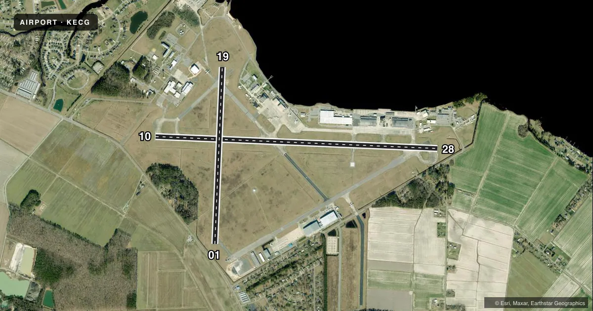
Runways & pattern
Full pagePattern entry · RWY 19
RIGHT TRAFFIC| Runway | Heading (°M) | Length | Surface | Traffic |
|---|---|---|---|---|
| 10/28 | 81° / 261° | 7,219 ft | CONC | 10 R |
| 01/19Favored | 351° / 171° | 4,518 ft | ASPH-CONC | 01 R · 19 R |
Runway end performance
| End | TORA | TODA | ASDA | LDA | VGSI | Approach lights | Obstruction |
|---|---|---|---|---|---|---|---|
| 10 | — | — | — | — | PAPI 2-box left(3°) | SALS | 15', road, 800' from thr, 0' R of cntrln, slope 40 |
| 28 | — | — | — | — | PAPI 2-box left(3°) | — | 22', trees, 428' from thr, 260' R of cntrln, slope 10 |
| 01 | — | — | — | — | VASI 4-box left(2.75°) | — | 15', road, 200' from thr, 230' R of cntrln, slope 0 |
| 19 | — | — | — | — | VASI 4-box left(2.75°) | — | — |
Declared distances in feet. TORA = takeoff run available, TODA = takeoff distance, ASDA = accelerate-stop, LDA = landing distance.
Airport sketch
Runways drawn to scale from FAA survey coordinates, rendered over satellite imagery. Not for navigation.
Approaches & charts
ILS · 1
Services on the field
Fuel grades, oxygen, maintenance, ramp storage and lighting — as declared to the FAA by the airport operator.
Fuel & services
- Fuel
- 100LLA1+
- Oxygen (bottled)
- Not available
- Oxygen (bulk)
- Not available
- Airframe repair
- Major
- Power plant repair
- Major
- Other services
- CHTR,INSTR,RNTL
Ramp & ground
- Transient storage
- Tie-down
- Landing fee
- No fee published
- Customs
- Not available
- Lighting schedule
- SEE RMK
- Beacon schedule
- SS-SR
- Beacon
- White / Green (civil land)(WG)
- Wind indicator
- Lighted
- Segmented circle
- No
Fuel & FBOs
Cheapest 100LL and Jet A on the field and nearby. Always confirm with the FBO before taxi.
Airport notes
Surface conditions, obstructions, local procedures, lighting outages and other notes published with each FAA cycle.
General notes
- NO LINE-OF-SIGHT BETWEEN RWY ENDS.
- ACFT WITH TAIL HEIGHTS TO 50 FT PARKED ON APRON FIRST 2000 FT FM RWY 28 R SIDE 250 FT FM RWY CNTRLN.
- FACILITIES AND RAMPS NORTH OF RWY 10/28 RSTRD TO OFFL CG BUS ONLY.
- INTERMITTENT TETHERED BLN OPNS 3 NM SE; DALGT HRS AT 5000 FT.
- SEASONAL LOW-FLYING AGRI ACFT BASED IN THE LOCAL AREA.
- COAST GUARD COMPLEX HAS NUMEROUS BLDGS WI THE BLDG RSTRN LINES.
- RWY 01/19 & TWY K WEST OF THE CIVIL RAMP CLSD TO ALL OPNS.
- ALL DOD TBJT ACFT FULL STOP ONLY, PRACTICE APCHS AND VFR TOUCH-N-GOS PROHIBITED.
- FLUID: SP LHOX OIL: O-133-156 TRAN ALERT- NO TRANS MAINT, LTD SVC, TRAN A/C MUST REMAIN WITH ACFT TO PROVIDE TECH DRCT/ASSIST IN SVCG.
- CG ALC RAMP ATTENDED 1200-2000Z++.
- CIV RAMP ATNDD M-F 0800-2100, SAT-SUN 0800-1700 FOR CIV ATTENDANT AFTER HRS & HOL C252-562-2472 DUR HR ATNDD.
- SAR MAY RQR H24 ATCT STAFF 0200-1300Z++; TRANS INTENTIONS IN THE BLIND ON 120.5.
- SEE FLIP AP/1 SUPP ARPT INFO.
- NOISE ABATEMENT PROCEDURES IN EFFECT, CALL AMGR 719-505-6367.
- ALL ACFT DESTINED FOR CG AIR STATION CTC ELIZABETH CITY AIR ON 345.0, 10 MIN PRIOR TO LDG. ALL ACFT DESTINED FOR CG ALC CTC ALC DUTY OFFICER (C252-333-5389) NLT 24HRS FOR PPR AND CTC ALC FLT OPS 123.1 PRIOR TO LANDING.
- RWY AND TWY SFC COND NOT MNT WKENDS OR MON-FRI BTN 2000Z-1200Z.
- MISC: NON-FRANGIBLE HIGH VOLTAGE BOXES LOCATED ON S EDGE OF ALC RAMP.
- MISC: PORTIONS OF ALC PRK RAMP NOT VIS FROM TWR.
- MISC: AFLD MOWING SEASON APR-OCT. EXPCT INCREASED BIRD ACT IN VCNTY OF MOWERS OPR ON AFLD.
- PPR IF ACN EXCEEDS PUBL PCN. CTC CG AFLD MGR C719-505-6367 TO OBTAIN APVL.
- FOR CD WHEN ATCT CLSD, CTC NORFOLK APCH AT 757-464-0757.
- RWY 10/28 INCRD POTENTIAL FOR HYDROPLANING DUE TO RUBBER DEPOSITS, CNTRLN OBSC.
Lighting notes
- ACTVT SALS RWY 10; HIRL RWY 10/28 - CTAF. WHEN ATCT CLSD, REILS RWY 10 & 28; PAPI RWY 10 & 28 OPR CONSLY. VASI RWY 01 & 19; MIRL RWY 01/19; TWY RWY 19 - OTS INDEFLY.
Fuel notes
- 100LL100LL FUEL 24 HR CREDIT CARD SVC AVBL.
- A1+DLA MILITARY FUELING CONTRACT SVC AVBL ON GA RAMP, US GOVT AIRCARD ACCEPTED, NO DELAY FOR FUEL.
Runway surface & condition
- 10/28TWIN-TANDEM WEIGHT BEARING CAPACITY 400000 LBS.
- 01/19RWY 01/19 CLSD INDEFLY.
Approach & departure obstructions
- 01CLSD INDEFLY HAS +6 FT FENCE 0-200 FT FM THR 200-250 FT L.
- 28HAS +11 FT ROAD 156 FT FM THR OFFSET 337 L OF CNTRLN.
- 01MKD WITH X CLOSED.
- 01CLSD INDEFLY APCH RATIO 20:1 FROM DSPLCD THR.
Other notes
- THIS IS A SHARED-USE ARPT. THE USCG OWNS AND OPERATES ALL RWYS AND THE MAJORITY OF THE TWYS. THE PASQUOTANK COUNTY AIRPORT AUTHORITY OPERATES THE FBO, CIVILIAN TERMINAL AND ASSOCIATED TAXIWAYS.
- TPA: ROTARY WING 1000 FT AGL/1011 FT MSL, FIXED WING 1500 FT AGL/1511 FT MSL.
- 2FOR GA ATTENDANCE AFTER HRS AND HOLIDAYS CALL 252-562-2472 OR CTC NOS. POSTED ON TRML DOOR.
- MANAGERMR. ROBERT POPP IS THE USCG AIRFIELD MANAGER (SENIOR AIRPORT AUTHORITY). EMAIL: ROBERT.A.POPP@USCG.MIL; PHONE 719-505-6367. MR. SCOTT HINTON IS THE ELIZABETH CITY RGNL ARPT DIR FOR THE ELIZABETH CITY-PASQUOTANK COUNTY ARPT AUTH. EMAIL: MANAGER@ECGAIRPORT.COM; PHONE: 252-335-5634.
- OWNERUSCG BASE - ELIZABETH CITY, AIRFIELD MANAGER: ROBERT POPP, PHONE: 719-505-6367; EMAIL: ROBERT.A.POPP@USCG.MIL
- 01/19PAVEMENT IS FAILED, NMRS RUTS, HEAVES, STRUCTURAL INTEGRITY UNKN. FOD POTENTIAL. SFC MRKS OBSC. NOT AUZD FOR USE.
VFR map & nearby airports
VFR sectional. Tap any ICAO chip to open that airport.
Key facts · KECG
Answer card- ICAO
- KECG
- Name
- ELIZABETH CITY CG AIR STATION/RGNL
- Location
- ELIZABETH CITY, NORTH CAROLINA
- Elevation
- 10.6 ft MSL
- Traffic pattern altitude
- 1,010.6 ft MSL (1,000 AGL)
- Control tower
- Towered · 1200-0300Z++.
- Total runways
- 2
- Longest runway
- 10/28 · 7,219 ft
- Published ILS approaches
- 1
- Published frequencies
- 9
- Magnetic variation
- 11°
- Current flight rules
- VFR
- Current wind
- 190° at 5 kt
- Favored runway now
- RWY 19
KECG is in Elizabeth City, North Carolina. Field elevation is 10.6 ft MSL, so this is a low coastal airport with little elevation to work against, but the shared-use setup means you need to pay attention to local procedures. There are two runways. The longest is 10/28 at 7,219 ft. Runway 01/19 is 4,518 ft, but it is not authorized for use. The airport has a control tower. Published tower hours are 1200-0300Z++. One ILS approach is available to runway 10. Pattern altitude is not published. Use the standard 1,000 ft AGL for light piston traffic unless ATC or the current Chart Supplement says otherwise.
The on-field FBO is Elizabeth City Regional Airport. It carries 100LL and Jet A. The civil ramp is attended on a published schedule, with after-hours contact information in the Chart Supplement. Search and rescue traffic can drive unusual tower staffing, so monitor 120.5 and be ready to transmit intentions in the blind when needed. Runway 01/19 and taxiway K west of the civil ramp are closed to all operations. There are also parked aircraft and Coast Guard facilities near the movement area, so keep a sharp scan on taxi and runway edges. Seasonal low-flying agricultural aircraft are based in the area. Check the current Chart Supplement before departure for any operational updates.