METAR & TAF KDRO
Current METAR
Observed 12:53Z
KDRO 271253Z AUTO 00000KT 10SM CLR 16/13 A3029 RMK AO2 SLP174 T01610128
- Wind
- 000° @ 0 kt
- Visibility
- 10 SM
- Temp / Dew
- 16°C / 13°C
- Altimeter
- 30.29 inHg
- Clouds
- CLR
- Density alt
- 7,956 ft
- Ceiling
- Unlimited
- Rules
- VFR
Airport info & contacts
Manager on record, flight service, ARTCC, attendance schedule and pattern altitude — published by the FAA and refreshed every 28 days.
Location
- From city
- 10 NM SE
- VFR sectional
- DENVER
- ARTCC
- ZDV · DENVER
- NOTAM facility
- DRO (NOTAM-D)
Airport manager
- Name
- ANTHONY VICARI - DIR OF AVIATION
- Phone
- (970) 382-6051
- Address
- 1000 AIRPORT ROAD BOX 15, DURANGO CO 81303
Flight service · Hours
- FSS DEN
- DENVER1-800-WX-BRIEF
- Attendance
- 0400-2400
Frequencies
Tap any row to copy the frequency to your clipboard.
Runways & pattern
Full pagePattern entry · RWY 03
LEFT TRAFFICRunway end performance
| End | TORA | TODA | ASDA | LDA | VGSI | Approach lights | Obstruction |
|---|---|---|---|---|---|---|---|
| 03 | 9,201' | 9,201' | 9,201' | 9,201' | PAPI 4-box left(3°) | MALSR | — |
| 21 | 9,201' | 9,201' | 9,201' | 9,201' | PAPI 4-box left(3°) | — | — |
Declared distances in feet. TORA = takeoff run available, TODA = takeoff distance, ASDA = accelerate-stop, LDA = landing distance.
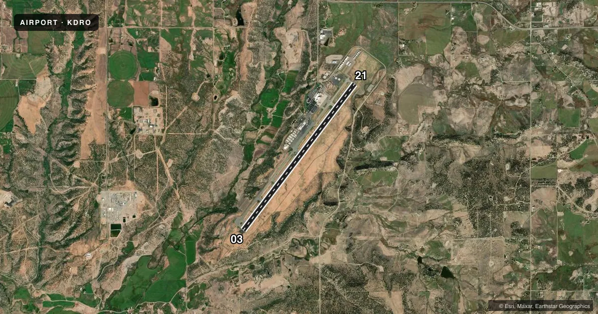
Airport sketch
Runways drawn to scale from FAA survey coordinates, rendered over satellite imagery. Not for navigation.
Approaches & charts
ILS · 1
Services on the field
Fuel grades, oxygen, maintenance, ramp storage and lighting — as declared to the FAA by the airport operator.
Fuel & services
- Fuel
- 100LLA
- Oxygen (bottled)
- Low pressure
- Airframe repair
- Major
- Power plant repair
- Major
- Other services
- AFRT,AMB,CHTR
Ramp & ground
- Transient storage
- Tie-down
- Hangar
- Landing fee
- No fee published
- Customs
- Not available
- Lighting schedule
- SEE RMK
- Beacon schedule
- SS-SR
- Beacon
- White / Green (civil land)(WG)
- Wind indicator
- Lighted
- Segmented circle
- Yes
Fuel & FBOs
Cheapest 100LL and Jet A on the field and nearby. Always confirm with the FBO before taxi.
Airport notes
Surface conditions, obstructions, local procedures, lighting outages and other notes published with each FAA cycle.
General notes
- COND UNMON AT NGT AFT LAST ACFT ARR UNTIL 0400; SEE NOTAMS.
- ARFF COVERAGE PRVDD DURG ACR TFC OPS; OTR TIMES 24 HR PPR - ARPT OPS 970-759-4342.
- HOP ON & INVOF ARPT.
- FOR CD CTC DENVER ARTCC ON FREQ. IF UNA, CTC FSS ON FREQ VIA RCO. IF UNA, CTC DENVER ARTCC AT 303-651-4257.
- LNDG FEE APPLICABLE.
Lighting notes
- MALSR RWY 03; REIL RWY 21; HIRL RWY 03/21 OPER ON PHOTOCELL; INCR/DECR INTST - CTAF. PAPI RWY 03 & 21 ON CONSLY; INCR/DECR INTST - CTAF. ACTVT PAPI RWY 03 & 21; INCR/DECR INTST - CTAF.
Runway surface & condition
- 03/21PCR VALUE: 880/F/D/X/T
Other notes
- PPR FOR UNSKED ACR OPS WITH MORE THAN 30 PAX SEATS - ARPT OPS 970-759-4342.
- 1AFT HR - 970-259-7400.
VFR map & nearby airports
VFR sectional. Tap any ICAO chip to open that airport.
Key facts · KDRO
Answer card- ICAO
- KDRO
- Name
- DURANGO-LA PLATA COUNTY
- Location
- DURANGO, COLORADO
- Elevation
- 6,689.4 ft MSL
- Traffic pattern altitude
- 7,689.4 ft MSL (1,000 AGL)
- Control tower
- Non-towered (use CTAF)
- Total runways
- 1
- Longest runway
- 03/21 · 9,201 ft
- Published ILS approaches
- 1
- Published frequencies
- 2
- Magnetic variation
- 10°
- Current flight rules
- VFR
- Current wind
- 000° at 0 kt
- Favored runway now
- –
Durango-La Plata County Airport is in Durango, Colorado. The field elevation is 6,689.4 ft MSL. It has one runway, 03/21, which is 9,201 ft long. There is no control tower, so expect CTAF and UNICOM on 122.8. The published pattern altitude is not listed, so use standard 1,000 ft AGL unless current NOTAMs or the Chart Supplement say otherwise.
Runway 03 has an ILS approach. The airport also has medium intensity approach lighting with runway alignment indicator lights on 03, runway end identifier lights on 21 and high intensity runway lights on both ends. PAPI is published for both runway ends. Lighting intensity is adjusted on CTAF.
Avflight Durango is on the field. It carries 100LL, Jet A and Jet A Prist. This is a high-elevation airport, so performance planning matters. Expect thinner air and longer takeoff rolls than you would at lower fields. The published remarks also say the airport condition is unmonitored at night after the last arrival until 0400. Check NOTAMs before a late arrival. There is also a landing fee. Verify the current details with the airport operator or the FBO directly before you go.