METAR & TAF KDKK
Current METAR
Observed 16:53Z
KDKK 271653Z AUTO 28007KT 10SM CLR 27/22 A2985 RMK AO2 SLP104 T02670217
- Wind
- 280° @ 7 kt
- Visibility
- 10 SM
- Temp / Dew
- 27°C / 22°C
- Altimeter
- 29.85 inHg
- Clouds
- CLR
- Density alt
- 2,385 ft
- Ceiling
- Unlimited
- Rules
- VFR
Airport info & contacts
Manager on record, flight service, ARTCC, attendance schedule and pattern altitude — published by the FAA and refreshed every 28 days.
Location
- From city
- 3 NM E
- VFR sectional
- DETROIT
- ARTCC
- ZOB · CLEVELAND
- NOTAM facility
- DKK (NOTAM-D)
Airport manager
- Name
- JOHN MACHEMER
- Phone
- 716-581-0062
- Address
- 3163 AIRPORT DR, JAMESTOWN NY 14701
Flight service · Hours
- FSS BUF
- BUFFALO1-800-WX-BRIEF
- Attendance
- 0700-1700
Frequencies
Tap any row to copy the frequency to your clipboard.
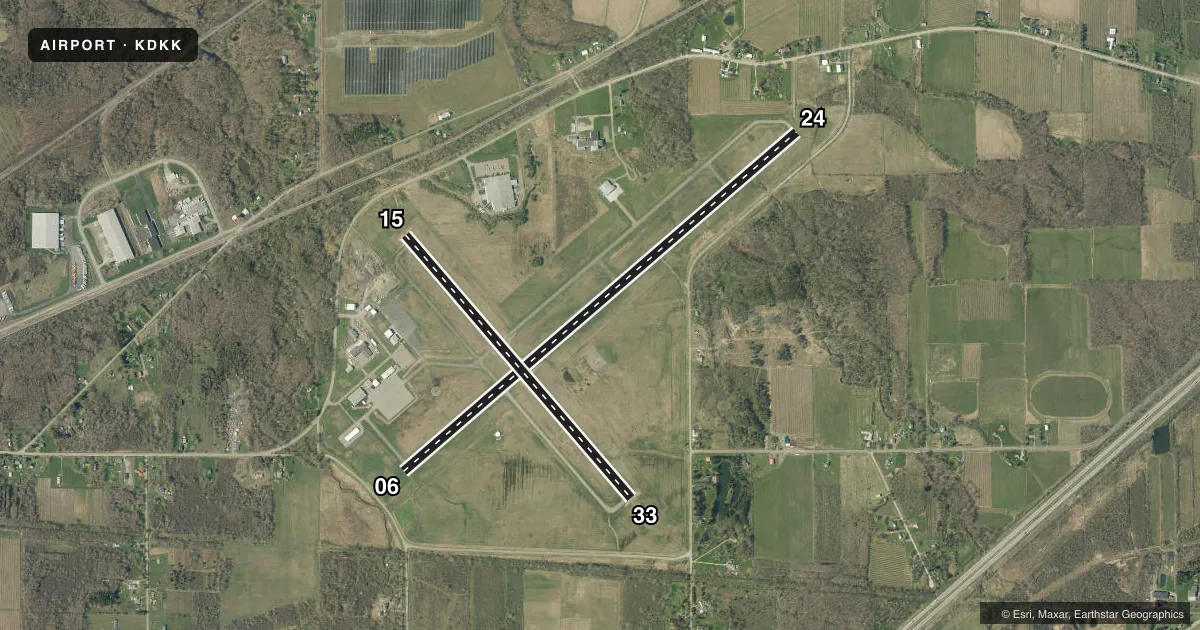
Runways & pattern
Full pagePattern entry · RWY 33
LEFT TRAFFIC| Runway | Heading (°M) | Length | Surface | Traffic |
|---|---|---|---|---|
| 06/24 | 39° / 219° | 6,000 ft | ASPH | Standard L |
| 15/33Favored | 129° / 309° | 4,000 ft | ASPH | Standard L |
Runway end performance
| End | TORA | TODA | ASDA | LDA | VGSI | Approach lights | Obstruction |
|---|---|---|---|---|---|---|---|
| 06 | — | — | — | — | PAPI 4-box left(3°) | — | — |
| 24 | — | — | — | — | PAPI 4-box left(3°) | — | 30', tree, 405' from thr, 44' R of cntrln, slope 6 |
| 15 | — | — | — | — | PAPI 4-box left(3°) | — | 70', tree, 787' from thr, 300' R of cntrln, slope 8 |
| 33 | — | — | — | — | PAPI 4-box left(3.1°) | — | 62', trees, 775' from thr, 273' R of cntrln, slope 9 |
Declared distances in feet. TORA = takeoff run available, TODA = takeoff distance, ASDA = accelerate-stop, LDA = landing distance.
Airport sketch
Runways drawn to scale from FAA survey coordinates, rendered over satellite imagery. Not for navigation.
Approaches & charts
Services on the field
Fuel grades, oxygen, maintenance, ramp storage and lighting — as declared to the FAA by the airport operator.
Fuel & services
- Fuel
- 100LLAA+
- Oxygen (bottled)
- Not available
- Oxygen (bulk)
- HIGH/LOW
- Airframe repair
- Minor
- Power plant repair
- Major
Ramp & ground
- Transient storage
- Tie-down
- Hangar
- Landing fee
- No fee published
- Customs
- Not available
- Lighting schedule
- SEE RMK
- Beacon schedule
- SS-SR
- Beacon
- White / Green (civil land)(WG)
- Wind indicator
- Lighted
- Segmented circle
- Yes
Fuel & FBOs
Cheapest 100LL and Jet A on the field and nearby. Always confirm with the FBO before taxi.
Airport notes
Surface conditions, obstructions, local procedures, lighting outages and other notes published with each FAA cycle.
General notes
- DEER & BIRDS INVOF AIRPORT
- FICONS NOT RGLRLY MNT.
- COLD TEMPERATURE AIRPORT. ALTITUDE CORRECTION REQUIRED AT OR BELOW -21C.
- FOR CD CTC BUFFALO ATCT AT 716-626-6939/6919.
Lighting notes
- ACTVT HIRL RWY 06/24, MIRL RWY 15/33, PAPI 06, 24, 15, & 33, & REIL RWY 6 & 24 -CTAF.
Other notes
- EXISTED PRIOR TO 1959.
- 1EXC FEDERAL HOLS.
VFR map & nearby airports
VFR sectional. Tap any ICAO chip to open that airport.
Key facts · KDKK
Answer card- ICAO
- KDKK
- Name
- CHAUTAUQUA COUNTY/DUNKIRK
- Location
- DUNKIRK, NEW YORK
- Elevation
- 692.3 ft MSL
- Traffic pattern altitude
- 1,692.3 ft MSL (1,000 AGL)
- Control tower
- Non-towered (use CTAF)
- Total runways
- 2
- Longest runway
- 06/24 · 6,000 ft
- Published ILS approaches
- 0
- Published frequencies
- 4
- Magnetic variation
- 10°
- Current flight rules
- VFR
- Current wind
- 280° at 7 kt
- Favored runway now
- RWY 33
Chautauqua County/Dunkirk Airport sits in Dunkirk, New York at 692.3 ft MSL. It has two asphalt runways. The longest is 06/24 at 6,000 ft. Runway 15/33 is 4,000 ft. The field is non-towered, so use CTAF 123.075 for local traffic calls. Buffalo handles approach and departure on 126.5 or 317.6. No ILS approaches are published here.
Pattern altitude is not published. Use the standard 1,000 ft AGL for light piston traffic unless the current Chart Supplement says otherwise. Centric Aviation is on the field. It carries 100LL, Jet A and Jet A Prist. Published remarks say airport operations are except federal holidays. They also note that FICONs are not regularly maintained. This is a cold temperature airport, so altitude correction is required at or below minus 21 degrees Celsius. Deer and birds are reported in the area. Keep a sharp lookout on taxi, takeoff and final.
Lighting is useful here after dark. Runway 06/24 has high intensity lighting. Runway 15/33 has medium intensity lighting. PAPI is published on all four runway ends. REIL is published on 6 and 24. If you need clearance delivery, contact Buffalo ATCT directly before departure. For any current noise, runway, or operational changes, check the current FAA Chart Supplement before you go.