METAR & TAF KCSG
Current METAR
Observed 09:51Z
KCSG 270951Z AUTO 00000KT 9SM CLR 25/24 A2989 RMK AO2 SLP116 T02500244
- Wind
- 000° @ 0 kt
- Visibility
- 9 SM
- Temp / Dew
- 25°C / 24°C
- Altimeter
- 29.89 inHg
- Clouds
- CLR
- Density alt
- 1,730 ft
- Ceiling
- Unlimited
- Rules
- VFR
Airport info & contacts
Manager on record, flight service, ARTCC, attendance schedule and pattern altitude — published by the FAA and refreshed every 28 days.
Location
- From city
- 3 NM NE
- VFR sectional
- ATLANTA
- ARTCC
- ZTL · ATLANTA
- NOTAM facility
- CSG (NOTAM-D)
Airport manager
- Name
- AMBER CLARK, A.A.E.
- Phone
- 706-575-0907
- Address
- 3250 W BRITT DAVID RD, COLUMBUS GA 31909
Flight service · Hours
- FSS MCN
- MACON1-800-WX-BRIEF
- Attendance
- ALL
Frequencies
Tap any row to copy the frequency to your clipboard.
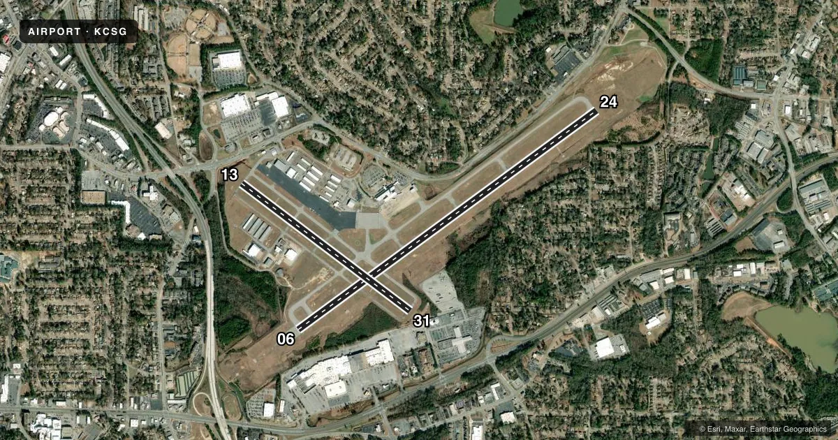
Runways & pattern
Full pagePattern entry · RWY 06
LEFT TRAFFIC| Runway | Heading (°M) | Length | Surface | Traffic |
|---|---|---|---|---|
| 06/24 | 52° / 232° | 6,997 ft | CONC | Standard L |
| 13/31 | 125° / 305° | 3,997 ft | ASPH | Standard L |
Runway end performance
| End | TORA | TODA | ASDA | LDA | VGSI | Approach lights | Obstruction |
|---|---|---|---|---|---|---|---|
| 06 | 6,997' | 6,997' | 6,997' | 6,997' | PAPI 4-box left(2.61°) | MALSR | 79', trees, 2450' from thr, 250' R of cntrln, slope 28 |
| 24 | 6,997' | 6,997' | 6,997' | 6,997' | PAPI 4-box left(3°) | — | 29', bldg, 690' from thr, 275' R of cntrln, slope 16 |
| 13 | 3,997' | 3,997' | 3,907' | 3,907' | PAPI 4-box left(3°) | — | 72', tree, 1300' from thr, 250' R of cntrln, slope 15 |
| 31 | 3,997' | 3,997' | 3,997' | 3,847' | PAPI 4-box left(3°) | — | 10', pole, 300' from thr, 50' R of cntrln, slope 10 |
Declared distances in feet. TORA = takeoff run available, TODA = takeoff distance, ASDA = accelerate-stop, LDA = landing distance.
Airport sketch
Runways drawn to scale from FAA survey coordinates, rendered over satellite imagery. Not for navigation.
Approaches & charts
ILS · 1
Services on the field
Fuel grades, oxygen, maintenance, ramp storage and lighting — as declared to the FAA by the airport operator.
Fuel & services
- Fuel
- 100LLA
- Oxygen (bottled)
- Not available
- Oxygen (bulk)
- Not available
- Airframe repair
- Major
- Power plant repair
- Major
- Other services
- AFRT,AMB,AVNCS,CARGO,CHTR,INSTR,RNTL,SURV
Ramp & ground
- Transient storage
- Tie-down
- Hangar
- Landing fee
- No fee published
- Customs
- Not available
- Lighting schedule
- SEE RMK
- Beacon schedule
- SS-SR
- Beacon
- White / Green (civil land)(WG)
- Wind indicator
- Lighted
- Segmented circle
- Yes
Fuel & FBOs
Cheapest 100LL and Jet A on the field and nearby. Always confirm with the FBO before taxi.
Airport notes
Surface conditions, obstructions, local procedures, lighting outages and other notes published with each FAA cycle.
General notes
- BIRDS ON & INVOF ARPT.
- FOR CD IF UNA TO CTC ON FSS FREQ, CTC ATLANTA APCH AT 678-364-6132, WHEN ATCT CLSD CTC ATLANTA ARTCC AT 770-210-7692.
- BE ALERT FOR RWY 6 AT TWY D INT DEP INSTRUCTIONS WITH RWY RMNG 5085 FT TORA/TODA/ASDA.
- BE ALERT FOR RWY 6 AT TWY F INT DEP INSTRUCTIONS WITH RWY RMNG 5623 FT TORA/TODA/ASDA.
Lighting notes
- ALL LGTS OPER 0900-2100. AFTER 2100, ACTVT MALSR RWY 06; REIL RWY 24; PAPI RWY 06 & 24; HIRL RWY 06/24; MIRL RWY 13/31; TWY LGTS; WINDCONE LGTS - CTAF. REIL RWY 13 & 31; PAPI RWY 13 & 31 OPER CONSLY.
Fuel notes
- 100LLSELF SERVE 100LL AVBL 24 HRS.
Runway surface & condition
- 06/24PCR VALUE: 458/F/C/X/T
- 13/31PCR VALUE: 75/F/B/X/T
- 13/31RWY 13/31 NOT AVBL FOR PART 121/PART 380 OPS WITH SKED PAX CARRYING OPS MORE THAN 9 PAX SEATS AND NON-SKED PAX CARRYING OPS MORE THAN 30 PAX SEATS.
Approach & departure obstructions
- 24+5 FT GND 200 FT FROM RWY END 500 FT RIGHT.
Other notes
- INDEX B ARFF EQUIP AVBL.
VFR map & nearby airports
VFR sectional. Tap any ICAO chip to open that airport.
Key facts · KCSG
Answer card- ICAO
- KCSG
- Name
- COLUMBUS
- Location
- COLUMBUS, GEORGIA
- Elevation
- 397.7 ft MSL
- Traffic pattern altitude
- 1,397.7 ft MSL (1,000 AGL)
- Control tower
- Towered · 0900-2100
- Total runways
- 2
- Longest runway
- 06/24 · 6,997 ft
- Published ILS approaches
- 1
- Published frequencies
- 13
- Magnetic variation
- 2°
- Current flight rules
- VFR
- Current wind
- 000° at 0 kt
- Favored runway now
- –
Columbus Airport sits in Columbus, Georgia. Field elevation is 397.7 ft MSL. It has two runways. The longest is runway 06/24 at 6,997 ft. Runway 13/31 is 3,997 ft. The tower is open 0900-2100. After hours, use the published lighting procedures and coordinate as needed with Atlanta Approach or Atlanta ARTCC if tower services are not available.
There is one ILS approach. It serves runway 06. Pattern altitude is not published. Use the standard 1,000 ft AGL pattern unless the current FAA Chart Supplement says otherwise. Flightways Columbus is on the field. It carries 100LL and Jet A. Self-serve 100LL is available 24 hours.
A few operational notes matter here. Runway 06 has published intersection departure notes at taxiway D and taxiway F. The Chart Supplement also calls out a small ground obstruction near the runway 24 end, 500 feet right of centerline. Birds are reported on and near the airport. Runway 13/31 is not available for certain large passenger operations. If you are planning a heavy or commercial flight, verify the runway limits before you go. The field is in the Columbus area, so expect normal towered-airport coordination and watch for traffic during the published tower hours.