METAR & TAF KCRP
Current METAR
Observed 12:51Z
KCRP 271251Z 15006KT 10SM FEW016 FEW250 26/24 A2995 RMK AO2 SLP142 T02560244
- Wind
- 150° @ 6 kt
- Visibility
- 10 SM
- Temp / Dew
- 26°C / 24°C
- Altimeter
- 29.95 inHg
- Clouds
- FEW
- Density alt
- 1,340 ft
- Ceiling
- Unlimited
- Rules
- VFR
Airport info & contacts
Manager on record, flight service, ARTCC, attendance schedule and pattern altitude — published by the FAA and refreshed every 28 days.
Location
- From city
- 5 NM W
- VFR sectional
- BROWNSVILLE
- ARTCC
- ZHU · HOUSTON
- NOTAM facility
- CRP (NOTAM-D)
Airport manager
- Name
- KEVIN SMITH
- Phone
- 361-289-0171
- Address
- 1000 INTERNATIONAL DR, CORPUS CHRISTI TX 78406
Flight service · Hours
- FSS SJT
- SAN ANGELO1-800-WX-BRIEF
- Attendance
- ALL
Frequencies
Tap any row to copy the frequency to your clipboard.
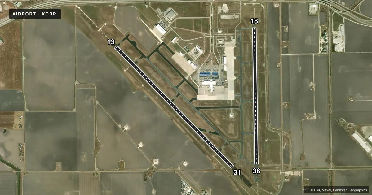
Runways & pattern
Full pagePattern entry · RWY 13
RIGHT TRAFFIC| Runway | Heading (°M) | Length | Surface | Traffic |
|---|---|---|---|---|
| 13/31Favored | 132° / 312° | 7,510 ft | ASPH | 13 R |
| 18/36 | 175° / 355° | 6,080 ft | ASPH | 36 R |
Runway end performance
| End | TORA | TODA | ASDA | LDA | VGSI | Approach lights | Obstruction |
|---|---|---|---|---|---|---|---|
| 13 | 7,510' | 7,510' | 7,510' | 7,510' | PAPI 4-box left(3°) | MALSR | 33', pole, 1782' from thr, 640' R of cntrln, slope 47 |
| 31 | 7,510' | 7,510' | 7,510' | 7,510' | PAPI 4-box left(3°) | MALSR | — |
| 18 | 6,080' | 6,080' | 6,080' | 6,080' | PAPI 4-box left(3°) | MALSR | 43', pole, 1930' from thr, 402' R of cntrln, slope 40 |
| 36 | 6,080' | 6,080' | 6,080' | 6,080' | — | MALSR | — |
Declared distances in feet. TORA = takeoff run available, TODA = takeoff distance, ASDA = accelerate-stop, LDA = landing distance.
Airport sketch
Runways drawn to scale from FAA survey coordinates, rendered over satellite imagery. Not for navigation.
Approaches & charts
ILS · 3
Services on the field
Fuel grades, oxygen, maintenance, ramp storage and lighting — as declared to the FAA by the airport operator.
Fuel & services
- Fuel
- 100LLA
- Oxygen (bottled)
- High pressure
- Oxygen (bulk)
- High pressure
- Airframe repair
- Major
- Power plant repair
- Major
- Other services
- AFRT,AVNCS,CARGO,CHTR,INSTR,RNTL,SALES
Ramp & ground
- Transient storage
- Tie-down
- Hangar
- Landing fee
- No fee published
- Customs
- Not available
- Lighting schedule
- SS-SR
- Beacon schedule
- SS-SR
- Beacon
- White / Green (civil land)(WG)
- Wind indicator
- Lighted
- Segmented circle
- Yes
Fuel & FBOs
Cheapest 100LL and Jet A on the field and nearby. Always confirm with the FBO before taxi.
Airport notes
Surface conditions, obstructions, local procedures, lighting outages and other notes published with each FAA cycle.
General notes
- CABANISS FIELD LCTD 5 MILES SE OF ARPT MAY BE MISTAKEN FOR CORPUS CHRISTI INTL ARPT. VFR TFC MAY BE OPERATING IN THE CABANISS FIELD TFC PATTERN.
- BIRDS ON & INVOF ARPT YEAR ROUND.
- CUDDIHY FIELD (CLSD ARPT) IS LCTD 4 MILES SOUTH OF ARPT MAY BE MISTAKEN FOR CORPUS CHRISTI INTL ARPT.
- ACFT AT TRML GATES ADZ GND CTL PRIOR TO PUSH.
- UNMANNED ACFT MAY BE OPRG 3 MI WEST OF ARPT DRG DALGT HRS AT OR BLW 400 FT AGL.
- CG - OFFL BUS, MIN 24 HR PPR. CTC CORPUS CHRISTI AIR 345.0 15 MIN PRIOR TO ENTERING CG RAMP. NO TRAN QRTS OR GOVT TRANSPORTATION AVBL. IF DESTN CG, INCL CGAS CORPUS CHRISTI IN RMK SEC OF FLT PLAN. SECTOR COMMAND CENTER: C361-939-0450.
Runway surface & condition
- 13/31PCR VALUE: 507/F/D/X/U
- 18/36PCR VALUE: 507/F/D/X/U
VFR map & nearby airports
VFR sectional. Tap any ICAO chip to open that airport.
Key facts · KCRP
Answer card- ICAO
- KCRP
- Name
- CORPUS CHRISTI INTL
- Location
- CORPUS CHRISTI, TEXAS
- Elevation
- 46.2 ft MSL
- Traffic pattern altitude
- 1,046.2 ft MSL (1,000 AGL)
- Control tower
- Towered · 24
- Total runways
- 2
- Longest runway
- 13/31 · 7,510 ft
- Published ILS approaches
- 3
- Published frequencies
- 30
- Magnetic variation
- 4°
- Current flight rules
- VFR
- Current wind
- 150° at 6 kt
- Favored runway now
- RWY 13
Corpus Christi International sits in Corpus Christi, Texas. Field elevation is 46.2 ft MSL. The airport has 2 asphalt runways. The longest is runway 13/31 at 7,510 ft. Runway 18/36 is 6,080 ft. The tower is open 24 hours. Three ILS approaches are published for runway ends 13, 31 and 36.
Pattern altitude is not published in the facts. Use the standard 1,000 ft AGL for light piston traffic unless the current FAA Chart Supplement says otherwise. The field is in a busy coastal metro area. Birds are reported year round. That matters on departure and in the pattern. There is also unmanned aircraft activity 3 miles west of the airport during daylight hours at or below 400 ft AGL. Cabaniss Field 5 miles southeast may be mistaken for Corpus Christi International. Cuddihy Field is a closed airport 4 miles south that can also cause confusion.
Sterling Air is on the field. It carries 100LL, Jet A and Jet A Prist. Atlantic Aviation is also on the field. It carries 100LL and Jet A. Aircraft at terminal gates next to ground control must contact ground control before pushback. If you are headed to the Coast Guard ramp, plan ahead. Published remarks call for prior permission. They also call for a call on Corpus Christi Air 345.0 before entering that area.