METAR & TAF KCGI
Current METAR
Observed 15:53Z
KCGI 271553Z 26007KT 10SM CLR 29/23 A2990 RMK AO2 SLP121 T02890233 $
- Wind
- 260° @ 7 kt
- Visibility
- 10 SM
- Temp / Dew
- 29°C / 23°C
- Altimeter
- 29.90 inHg
- Clouds
- CLR
- Density alt
- 2,128 ft
- Ceiling
- Unlimited
- Rules
- VFR
Airport info & contacts
Manager on record, flight service, ARTCC, attendance schedule and pattern altitude — published by the FAA and refreshed every 28 days.
Location
- From city
- 5 NM SW
- VFR sectional
- ST LOUIS
- ARTCC
- ZME · MEMPHIS
- NOTAM facility
- CGI (NOTAM-D)
Airport manager
- Name
- JOJO STUART
- Phone
- 573-334-6230
- Address
- PO BOX 617, CAPE GIRARDEAU MO 63702
Flight service · Hours
- FSS STL
- SAINT LOUIS1-800-WX-BRIEF
- Attendance
- MON-FRI · 0600-1900
- SAT-SUN · 0600-1800
Frequencies
Tap any row to copy the frequency to your clipboard.
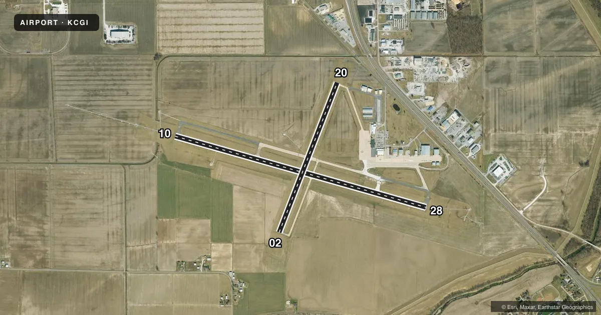
Runways & pattern
Full pagePattern entry · RWY 28
LEFT TRAFFIC| Runway | Heading (°M) | Length | Surface | Traffic |
|---|---|---|---|---|
| 10/28Favored | 104° / 284° | 6,500 ft | CONC | Standard L |
| 02/20 | 19° / 199° | 3,997 ft | ASPH-CONC | Standard L |
Runway end performance
| End | TORA | TODA | ASDA | LDA | VGSI | Approach lights | Obstruction |
|---|---|---|---|---|---|---|---|
| 10 | 6,500' | 6,500' | 6,500' | 6,500' | — | MALSR | — |
| 28 | 6,500' | 6,500' | 6,500' | 6,500' | VASI 2-box left(3°) | ODALS | 160', tree, 5600' from thr, 1100' R of cntrln, slope 33 |
| 02 | 3,997' | 3,997' | 3,997' | 3,997' | VASI 4-box left(4°) | — | 70', tree, 1500' from thr, 450' R of cntrln, slope 18 |
| 20 | 3,997' | 3,997' | 3,997' | 3,997' | VASI 4-box left(3°) | — | — |
Declared distances in feet. TORA = takeoff run available, TODA = takeoff distance, ASDA = accelerate-stop, LDA = landing distance.
Airport sketch
Runways drawn to scale from FAA survey coordinates, rendered over satellite imagery. Not for navigation.
Approaches & charts
ILS · 1
Services on the field
Fuel grades, oxygen, maintenance, ramp storage and lighting — as declared to the FAA by the airport operator.
Fuel & services
- Fuel
- 100LLA
- Oxygen (bottled)
- High pressure
- Oxygen (bulk)
- Not available
- Airframe repair
- Major
- Power plant repair
- Major
- Other services
- AFRT,AVNCS,CHTR,INSTR,RNTL,SALES
Ramp & ground
- Transient storage
- Tie-down
- Hangar
- Landing fee
- No fee published
- Customs
- Not available
- Lighting schedule
- SEE RMK
- Beacon schedule
- SS-SR
- Beacon
- White / Green (civil land)(WG)
- Wind indicator
- Lighted
- Segmented circle
- No
Fuel & FBOs
Cheapest 100LL and Jet A on the field and nearby. Always confirm with the FBO before taxi.
Airport notes
Surface conditions, obstructions, local procedures, lighting outages and other notes published with each FAA cycle.
General notes
- (E110) STANDBY GEN FOR FAA FAC ONLY
- NORTHERN 100 FT TWY 'C' NOT VISIBLE FM CONTROL TOWER.
- FOR CD CTC MEMPHIS ARTCC AT 901-368-8453/8449.
Lighting notes
- ACTVT MALSR RWY 10; ODALS RWY 28; HIRL RWY 10/28; MIRL RWY 02/20 - CTAF.
Runway surface & condition
- 02/20PCR VALUE: 185/R/D/W/T
- 10/28PCR VALUE: 310/R/D/W/T
- 02/20RWY 02/20 NOT AVBL FOR PART 121/PART 380 OPS WITH SKED PAX CARRYING OPS MORE THAN 9 PAX SEATS AND NON-SKED PAX CARRYING OPS MORE THAN 30 PAX SEATS.
Other notes
- 1FOR SVC AFT HRS CALL 573-335-6632.
VFR map & nearby airports
VFR sectional. Tap any ICAO chip to open that airport.
Key facts · KCGI
Answer card- ICAO
- KCGI
- Name
- CAPE GIRARDEAU RGNL
- Location
- CAPE GIRARDEAU, MISSOURI
- Elevation
- 341.5 ft MSL
- Traffic pattern altitude
- 1,341.5 ft MSL (1,000 AGL)
- Control tower
- Towered · 0700-1900 MON-FRI; 0700-1700 SAT-SUN
- Total runways
- 2
- Longest runway
- 10/28 · 6,500 ft
- Published ILS approaches
- 1
- Published frequencies
- 4
- Magnetic variation
- 2°
- Current flight rules
- VFR
- Current wind
- 260° at 7 kt
- Favored runway now
- RWY 28
Cape Girardeau Rgnl sits in Cape Girardeau, Missouri. Field elevation is 341.5 ft MSL. The airport has two runways. The longest is runway 10/28 at 6,500 ft. Runway 02/20 is 3,997 ft. The tower is open 0700-1900 Monday through Friday. Weekend tower hours are 0700-1700 Saturday and Sunday. One ILS approach is published for runway 10.
Pattern altitude is not published in the facts. Use the standard 1,000 ft AGL for light piston traffic unless the current Chart Supplement says otherwise. Cape Aviation is on the field. It carries 100LL and Jet A with Prist. Call ahead at (573) 335-6632 for after-hours service or current ramp needs.
A few operational notes matter here. The northern 100 feet of taxiway C is not visible from the tower. Runway 10 has MALSR lighting. Runway 28 has an omnidirectional approach lighting system. High intensity runway lights are on 10 and 28. Medium intensity runway lights are on 02 and 20. For clearance delivery, contact Memphis ARTCC. Runway 02/20 is not available for certain large Part 121 and Part 380 passenger operations. Check the current Chart Supplement for any noise or curfew restrictions before flying into the field.