METAR & TAF KBVX
Current METAR
Observed 18:56Z
KBVX 271856Z AUTO 23010KT 180V250 10SM FEW060 37/23 A2988 RMK AO2 SLP113 T03670233 $
- Wind
- 230° @ 10 kt
- Visibility
- 10 SM
- Temp / Dew
- 37°C / 23°C
- Altimeter
- 29.88 inHg
- Clouds
- FEW
- Density alt
- 3,266 ft
- Ceiling
- Unlimited
- Rules
- VFR
Airport info & contacts
Manager on record, flight service, ARTCC, attendance schedule and pattern altitude — published by the FAA and refreshed every 28 days.
Location
- From city
- 3 NM S
- VFR sectional
- MEMPHIS
- Pattern altitude
- 785 ft AGL · 1,250 ft MSL
- ARTCC
- ZME · MEMPHIS
- NOTAM facility
- BVX (NOTAM-D)
Airport manager
- Name
- JUSTIN THOMPSON
- Phone
- 870-251-1244
- Address
- 1126 BATESVILLE BLVD, BATESVILLE AR 72501
Flight service · Hours
- FSS JBR
- JONESBORO1-800-WX-BRIEF
- Attendance
- 0730-1730
- 1730-0730
Frequencies
Tap any row to copy the frequency to your clipboard.
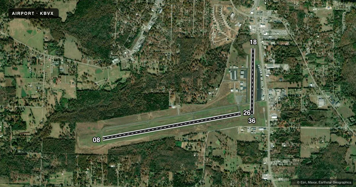
Runways & pattern
Full pagePattern entry · RWY 26
LEFT TRAFFIC| Runway | Heading (°M) | Length | Surface | Traffic |
|---|---|---|---|---|
| 08/26Favored | 79° / 259° | 6,002 ft | ASPH | Standard L |
| 18/36 | 180° / 0° | 2,804 ft | ASPH | Standard L |
Runway end performance
| End | TORA | TODA | ASDA | LDA | VGSI | Approach lights | Obstruction |
|---|---|---|---|---|---|---|---|
| 08 | — | — | — | — | PAPI 4-box left(3°) | — | — |
| 26 | — | — | — | — | PAPI 4-box left(3°) | — | 32', tree, 1320' from thr, 0' R of cntrln, slope 35 |
| 18 | — | — | — | — | — | — | 45', tree, 800' from thr, 180' R of cntrln, slope 13 |
| 36 | — | — | — | — | — | — | 10', road, 275' from thr, 0' R of cntrln, slope 7 |
Declared distances in feet. TORA = takeoff run available, TODA = takeoff distance, ASDA = accelerate-stop, LDA = landing distance.
Airport sketch
Runways drawn to scale from FAA survey coordinates, rendered over satellite imagery. Not for navigation.
Approaches & charts
ILS · 1
Services on the field
Fuel grades, oxygen, maintenance, ramp storage and lighting — as declared to the FAA by the airport operator.
Fuel & services
- Fuel
- 100LLA+
- Oxygen (bottled)
- Not available
- Oxygen (bulk)
- Not available
- Airframe repair
- Major
- Power plant repair
- Major
- Other services
- AMB,INSTR,RNTL
Ramp & ground
- Transient storage
- Tie-down
- Hangar
- Landing fee
- No fee published
- Customs
- Not available
- Lighting schedule
- SEE RMK
- Beacon schedule
- SS-SR
- Beacon
- White / Green (civil land)(WG)
- Wind indicator
- Lighted
- Segmented circle
- Yes
Fuel & FBOs
Cheapest 100LL and Jet A on the field and nearby. Always confirm with the FBO before taxi.
Airport notes
Surface conditions, obstructions, local procedures, lighting outages and other notes published with each FAA cycle.
General notes
- FOR CD CTC MEMPHIS ARTCC AT 901-368-8453/8449.
Lighting notes
- ACTVT REIL RWYS 08, 26; MIRL RWY 08/26 - CTAF.
Fuel notes
- 100LL100LL SELF SVC AVBL WITH CREDIT CARD. FOR SVC AFTER HRS CALL 870-251-1244, FEE CHRGD.
- A+JET A+ SELF SERVE UNAVAILABLE
Runway surface & condition
- 08/26(2D) TAXIWAYS LIMITED TO 204K - APRONS LIMITED TO 184K
- 08/26(D) TAXIWAYS LIMITED TO 77K - APRONS LIMITED TO 67K
- 18/36(D) TAXIWAYS LIMITED TO 77K - APRONS LIMITED TO 67K
- 08/26(S) TAXIWAYS LIMITED TO 31K - APRONS LIMITED TO 29K
- 18/36(S) TAXIWAYS LIMITED TO 31K - APRONS LIMITED TO 29K
Approach & departure obstructions
- 26UNUSBL BYD 7 DEGS LEFT AND 7 DEGS RIGHT OF RWY CNTRLN.
Other notes
- THIS AIRPORT HAS BEEN SURVEYED BY THE NATIONAL GEODETIC SURVEY.
- 2CALL OUT FEE APPLIES
VFR map & nearby airports
VFR sectional. Tap any ICAO chip to open that airport.
Key facts · KBVX
Answer card- ICAO
- KBVX
- Name
- BATESVILLE RGNL
- Location
- BATESVILLE, ARKANSAS
- Elevation
- 465 ft MSL
- Traffic pattern altitude
- 1,250 ft MSL (785 AGL)
- Control tower
- Non-towered (use CTAF)
- Total runways
- 2
- Longest runway
- 08/26 · 6,002 ft
- Published ILS approaches
- 1
- Published frequencies
- 2
- Magnetic variation
- 1°
- Current flight rules
- VFR
- Current wind
- 230° at 10 kt
- Favored runway now
- RWY 26
Batesville Rgnl is in Batesville, Arkansas. The field elevation is 465 ft MSL. It has two asphalt runways. The longest is runway 08/26 at 6,002 ft. There is no control tower, so use CTAF 122.8 for traffic calls and ground coordination. The published pattern altitude is 785 ft AGL, which is 1,250 ft MSL.
Runway 08 has an ILS approach. That is the only ILS listed in the facts. Runway lighting is available on 08 and 26. It includes runway end identifier lights and medium intensity runway lights. The airport carries self-serve 100LL with credit card. After hours service is available by phone. Jet A plus self-serve is not available. There is no on-field FBO listed in the facts, so call the airport operator or the FBO directly before arrival if you need handling or fuel details.
For a first-time arrival, pay attention to the runway weight notes and the soft or dry condition limits on taxiways and aprons. Clearance delivery is handled through Memphis ARTCC. This is a non-towered field. Plan your arrival, make your position calls and expect local traffic to be on the common frequency.