METAR & TAF KBKV
Current METAR
Observed 18:23Z
KBKV 271823Z 28013G22KT 10SM TS SCT027 BKN110 27/23 A2995 RMK TS W
- Wind
- 280° @ 13G22 kt
- Visibility
- 10 SM
- Temp / Dew
- 27°C / 23°C
- Altimeter
- 29.95 inHg
- Clouds
- BKN
- Density alt
- 1,497 ft
- Ceiling
- 11,000 ft AGL
- Rules
- VFR
Airport info & contacts
Manager on record, flight service, ARTCC, attendance schedule and pattern altitude — published by the FAA and refreshed every 28 days.
Location
- From city
- 6 NM SW
- VFR sectional
- JACKSONVILLE
- ARTCC
- ZMA · MIAMI
- NOTAM facility
- BKV (NOTAM-D)
Airport manager
- Name
- STEVE MILLER
- Phone
- 352-540-6342
- Address
- 15800 FLIGHT PATH DR, BROOKSVILLE FL 34604
Flight service · Hours
- FSS PIE
- SAINT PETERSBURG1-800-WX-BRIEF
- Attendance
- 0700-1800
Frequencies
Tap any row to copy the frequency to your clipboard.
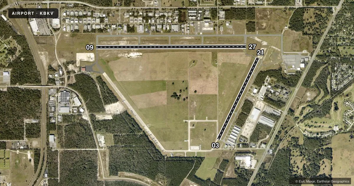
Runways & pattern
Full pagePattern entry · RWY 27
LEFT TRAFFIC| Runway | Heading (°M) | Length | Surface | Traffic |
|---|---|---|---|---|
| 09/27Favored | 86° / 266° | 7,001 ft | ASPH | Standard L |
| 03/21 | 22° / 202° | 4,200 ft | CONC | Standard L |
Runway end performance
| End | TORA | TODA | ASDA | LDA | VGSI | Approach lights | Obstruction |
|---|---|---|---|---|---|---|---|
| 09 | — | — | — | — | PAPI 4-box left(3°) | MALSR | 63', trees, 3135' from thr, 385' R of cntrln, slope 46 |
| 27 | — | — | — | — | PAPI 4-box left(3°) | — | 99', trees, 3540' from thr, 75' R of cntrln, slope 34 |
| 03 | — | — | — | — | PAPI 4-box left(3°) | — | 51', trees, 1155' from thr, 250' R of cntrln, slope 18 |
| 21 | — | — | — | — | PAPI 4-box left(3°) | — | 81', trees, 2960' from thr, 0' R of cntrln, slope 34 |
Declared distances in feet. TORA = takeoff run available, TODA = takeoff distance, ASDA = accelerate-stop, LDA = landing distance.
Airport sketch
Runways drawn to scale from FAA survey coordinates, rendered over satellite imagery. Not for navigation.
Approaches & charts
ILS · 1
Services on the field
Fuel grades, oxygen, maintenance, ramp storage and lighting — as declared to the FAA by the airport operator.
Fuel & services
- Fuel
- 100LLA
- Oxygen (bottled)
- Low pressure
- Airframe repair
- Major
- Power plant repair
- Major
- Other services
- AMB,AVNCS,CHTR,INSTR,RNTL,SALES,SURV
Ramp & ground
- Transient storage
- Tie-down
- Hangar
- Landing fee
- No fee published
- Customs
- Not available
- Lighting schedule
- SEE RMK
- Beacon schedule
- SS-SR
- Beacon
- White / Green (civil land)(WG)
- Wind indicator
- Lighted
- Segmented circle
- Yes
Fuel & FBOs
Cheapest 100LL and Jet A on the field and nearby. Always confirm with the FBO before taxi.
Airport notes
Surface conditions, obstructions, local procedures, lighting outages and other notes published with each FAA cycle.
General notes
- WILDLIFE ON AND INVOF ARPT.
- FOR CD IF UNA TO CTC ON FSS FREQ, CTC TAMPA APCH AT 813-878-2528.
- PPR 352-797-5813. PRK RAMP 42.525.
Lighting notes
- DUSK-2200. MALSR RWY 9; MIRL RWY 03/21 & 09/27 PRESET LOW INTST DUSK-2200, TO INCR INTST AND ACTVT AFTER 2200 - CTAF.
Other notes
- 03/21LONG AND TRANSVERSE CRACKING PRODUCING LOOSE AGGREGATE.
VFR map & nearby airports
VFR sectional. Tap any ICAO chip to open that airport.
Key facts · KBKV
Answer card- ICAO
- KBKV
- Name
- BROOKSVILLE-TAMPA BAY RGNL
- Location
- BROOKSVILLE, FLORIDA
- Elevation
- 76.1 ft MSL
- Traffic pattern altitude
- 1,076.1 ft MSL (1,000 AGL)
- Control tower
- Towered · 0700-2200
- Total runways
- 2
- Longest runway
- 09/27 · 7,001 ft
- Published ILS approaches
- 1
- Published frequencies
- 8
- Magnetic variation
- 4°
- Current flight rules
- VFR
- Current wind
- 280° at 13 kt
- Favored runway now
- RWY 27
KBKV sits in Brooksville, Florida. Field elevation is 76.1 ft MSL. The airport has two runways. The longest is 09/27 at 7,001 ft. Runway 03/21 is 4,200 ft. The tower is open daily from 0700 to 2200. One ILS approach is published for Runway 09. Pattern altitude is not published in the facts, so use standard 1,000 ft AGL for light piston traffic unless the current Chart Supplement says otherwise.
Two FBOs are on the field. Sentinel Services Group carries 100LL. American Aviation carries 100LL, Jet A and Jet A Prist. If you need current ramp or parking instructions, confirm with the airport operator or the FBO directly before arrival. Published remarks also note prior permission is required. The airport says to call 352-797-5813. Park on ramp 42.525. Wildlife is reported on and near the airport, so keep that in mind on taxi and takeoff.
Runway 03/21 has long and transverse cracking with loose aggregate. That is worth checking before you plan a landing there. Lighting is on from dusk to 2200. Runway 09 has a MALSR. Medium intensity lights on 03/21 and 09/27 are preset to low intensity from dusk to 2200. After 2200, use the CTAF to increase intensity and activate lighting. For clearance delivery issues, Tampa Approach can be reached at 813-878-2528. The field uses a towered environment, so expect normal controlled-airport sequencing during the published tower hours.