METAR & TAF KBKL
Current METAR
Observed 19:53Z
KBKL 271953Z 23009KT 10SM FEW040 30/20 A2978 RMK AO2 SLP079 T03000200
- Wind
- 230° @ 9 kt
- Visibility
- 10 SM
- Temp / Dew
- 30°C / 20°C
- Altimeter
- 29.78 inHg
- Clouds
- FEW
- Density alt
- 2,697 ft
- Ceiling
- Unlimited
- Rules
- VFR
Airport info & contacts
Manager on record, flight service, ARTCC, attendance schedule and pattern altitude — published by the FAA and refreshed every 28 days.
Location
- From city
- 1 NM N
- VFR sectional
- DETROIT
- ARTCC
- ZOB · CLEVELAND
- NOTAM facility
- BKL (NOTAM-D)
Airport manager
- Name
- JOEL WOODS
- Phone
- 216-781-6411
- Address
- 1501 N MARGINAL RD, CLEVELAND OH 44114
Flight service · Hours
- FSS CLE
- CLEVELAND1-800-WX-BRIEF
- Attendance
- ALL
Frequencies
Tap any row to copy the frequency to your clipboard.
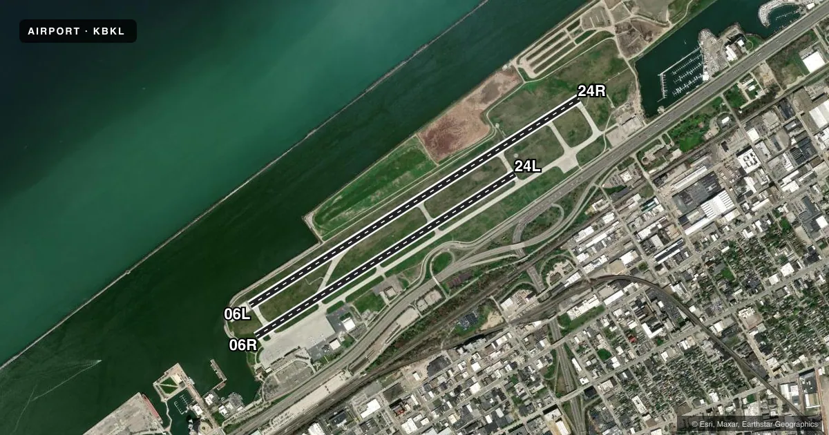
Runways & pattern
Full pagePattern entry · RWY 24R
RIGHT TRAFFIC| Runway | Heading (°M) | Length | Surface | Traffic |
|---|---|---|---|---|
| 06L/24RFavored | 51° / 231° | 6,604 ft | ASPH | 24R R |
| 06R/24L | 51° / 231° | 5,197 ft | ASPH | 24L R |
Runway end performance
| End | TORA | TODA | ASDA | LDA | VGSI | Approach lights | Obstruction |
|---|---|---|---|---|---|---|---|
| 06L | 6,503' | 6,503' | 6,503' | 6,325' | PAPI 4-box right(3°) | — | — |
| 24R | 6,603' | 6,603' | 6,603' | 6,003' | PAPI 4-box right(3°) | MALSF | 122', bldg, 3364' from thr, 837' R of cntrln, slope 25 |
| 06R | 5,199' | 5,199' | 5,199' | 4,924' | — | — | — |
| 24L | 5,199' | 5,199' | 5,199' | 5,199' | — | — | 274', ant, 6560' from thr, 1222' R of cntrln, slope 23 |
Declared distances in feet. TORA = takeoff run available, TODA = takeoff distance, ASDA = accelerate-stop, LDA = landing distance.
Airport sketch
Runways drawn to scale from FAA survey coordinates, rendered over satellite imagery. Not for navigation.
Approaches & charts
ILS · 1
Services on the field
Fuel grades, oxygen, maintenance, ramp storage and lighting — as declared to the FAA by the airport operator.
Fuel & services
- Fuel
- 100LLA
- Oxygen (bottled)
- Not available
- Oxygen (bulk)
- HIGH/LOW
- Airframe repair
- Major
- Power plant repair
- Major
- Other services
- AFRT,AMB,AVNCS,CARGO,CHTR,INSTR
Ramp & ground
- Transient storage
- Tie-down
- Hangar
- Landing fee
- Yes
- Customs
- Not available
- Lighting schedule
- SEE RMK
- Beacon schedule
- SS-SR
- Beacon
- White / Green (civil land)(WG)
- Wind indicator
- Lighted
Fuel & FBOs
Cheapest 100LL and Jet A on the field and nearby. Always confirm with the FBO before taxi.
Airport notes
Surface conditions, obstructions, local procedures, lighting outages and other notes published with each FAA cycle.
General notes
- BIRDS AND WATERFOWL ON & INVOF ARPT.
- FLIGHT NOTIFICATION SERVICE (ADCUS) AVBL 24 HRS MON-FRI REQ FOR SERVICE ON SAT; SUN & HOLS MUST BE MADE PRIOR TO 1630 ON FRI; 2 HRS ADVANCE NOTICE REQUIRED CALL 216-267-3600. PRIVATE ACFT & GENERAL AVIATION ONLY.
- 72 FT SHIP CRANE 1300 FT SW OF RWY 06R.
- FOR CD WHEN ATCT CLSD CTC CLEVELAND APCH AT 216-352-2323.
Lighting notes
- WHEN ATCT CLSD ACTVT MALSF RWY 24R; REIL RWY 06L - CTAF. HIRL RWY 06L/24R PRESET MED INTST, TO INCR INTST RDO REQ ON UNICOM. PAPI RWY 06L & 24R OPR CONSLY.
Runway surface & condition
- 06L/24RPCR VALUE: 426/F/C/X/T
- 06R/24LRWY 06R/24L NOT AVBL FOR PART 121/PART 380 OPS WITH SKED PAX CARRYING OPS MORE THAN 9 PAX SEATS AND NON-SKED PAX CARRYING OPS MORE THAN 30 PAX SEATS. CLSD WHEN ATCT CLSD.
Approach & departure obstructions
- 06LUNUSBL BYD 5 DEGS RIGHT OF CNTRLN.
- 24RUNUSBL BYD 8 DEGS LEFT OF CRS.
- 06LRWY 06L/24R & RWY 06R/24L APCH SFCS HAVE NAVIGABLE WATERWAYS CREATING POSSIBLE VESSEL OBSTRUCTION AREAS - CHECK LOCAL NOTAMS FOR CURRENT ACTIVITY; VESSEL HEIGHT; ETC.
Other notes
- HEL ASP: PRIOR TO PART 157.
- CLSD TO SKEDD ACR OPS GTR THAN 9 PAX SEATS. PPR FOR UNSKED ACR OPS WITH MORE THAN 30 PAX SEATS CALL AMGR.
- FEE SKED BASED ON NR OF ENGINES AND GWT.
VFR map & nearby airports
VFR sectional. Tap any ICAO chip to open that airport.
Key facts · KBKL
Answer card- ICAO
- KBKL
- Name
- BURKE LAKEFRONT
- Location
- CLEVELAND, OHIO
- Elevation
- 583.5 ft MSL
- Traffic pattern altitude
- 1,583.5 ft MSL (1,000 AGL)
- Control tower
- Towered · 0700 MON TO 2300 FRI; 0700-2300 SAT; SUN 0800-0000
- Total runways
- 2
- Longest runway
- 06L/24R · 6,604 ft
- Published ILS approaches
- 1
- Published frequencies
- 11
- Magnetic variation
- 7°
- Current flight rules
- VFR
- Current wind
- 230° at 9 kt
- Favored runway now
- RWY 24R
Burke Lakefront Airport sits in Cleveland, Ohio. Field elevation is 583.5 ft MSL. The airport has two asphalt runways. The longest is 6,604 ft on 06L/24R. The other runway is 06R/24L at 5,197 ft. The tower is open 0700 Monday through 2300 Friday. Saturday hours are 0700 to 2300. Sunday hours are 0800 to 0000. One ILS is published for runway 24R. Pattern altitude is not published in the facts, so use the standard 1,000 ft AGL unless current local guidance says otherwise.
Signature Aviation is on the field. It carries 100LL and Jet A. Birds and waterfowl are a known factor here because of the lakefront setting. That matters on departure and arrival. Runway 24R also has a note that it is unusable beyond 8 degrees left of course. Runway 06L is unusable beyond 5 degrees right of centerline. The airport also has lighting notes for tower-closed operations. MALSR on 24R and REIL on 06L are activated by CTAF. High intensity lights on 06L and 24R start at medium. Request a higher setting on UNICOM if needed. For a first-time arrival, pay attention to the lakefront environment. Also note the published runway limits and the tower hours. When the tower is closed, clearance delivery goes through Cleveland Approach.