METAR & TAF KBJC
Current METAR
Observed 07:35Z
KBJC 280735Z AUTO 04005KT 10SM CLR 23/13 A3016 RMK AO2
- Wind
- 040° @ 5 kt
- Visibility
- 10 SM
- Temp / Dew
- 23°C / 13°C
- Altimeter
- 30.16 inHg
- Clouds
- CLR
- Density alt
- 7,697 ft
- Ceiling
- Unlimited
- Rules
- VFR
Airport info & contacts
Manager on record, flight service, ARTCC, attendance schedule and pattern altitude — published by the FAA and refreshed every 28 days.
Location
- From city
- 9 NM NW
- VFR sectional
- DENVER
- ARTCC
- ZDV · DENVER
- NOTAM facility
- BJC (NOTAM-D)
Airport manager
- Name
- ERICK DAHL
- Phone
- (303) 271-4851
- Address
- 11755 AIRPORT WAY, BROOMFIELD CO 80021
Flight service · Hours
- FSS DEN
- DENVER1-800-WX-BRIEF
- Attendance
- ALL
Frequencies
Tap any row to copy the frequency to your clipboard.
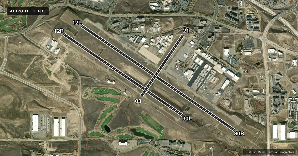
Runways & pattern
Full pagePattern entry · RWY 03
LEFT TRAFFIC| Runway | Heading (°M) | Length | Surface | Traffic |
|---|---|---|---|---|
| 12L/30R | 115° / 295° | 9,000 ft | ASPH | 30R R |
| 12R/30L | 115° / 295° | 7,002 ft | ASPH | 12R R |
| 03/21Favored | 25° / 205° | 3,600 ft | ASPH | 21 R |
Runway end performance
| End | TORA | TODA | ASDA | LDA | VGSI | Approach lights | Obstruction |
|---|---|---|---|---|---|---|---|
| 12L | 9,000' | 9,000' | 9,000' | 9,000' | PAPI 4-box left(3°) | — | — |
| 30R | 9,000' | 9,000' | 9,000' | 9,000' | PAPI 4-box left(3°) | MALSR | — |
| 12R | 7,002' | 7,002' | 7,002' | 7,002' | PAPI 2-box left(3°) | — | — |
| 30L | 7,002' | 7,002' | 7,002' | 7,002' | PAPI 2-box left(3°) | — | — |
| 03 | 3,600' | 3,600' | 3,600' | 3,600' | PAPI 2-box left(3°) | — | — |
| 21 | 3,600' | 3,600' | 3,600' | 3,600' | PAPI 2-box left(3°) | — | — |
Declared distances in feet. TORA = takeoff run available, TODA = takeoff distance, ASDA = accelerate-stop, LDA = landing distance.
Airport sketch
Runways drawn to scale from FAA survey coordinates, rendered over satellite imagery. Not for navigation.
Approaches & charts
ILS · 1
Services on the field
Fuel grades, oxygen, maintenance, ramp storage and lighting — as declared to the FAA by the airport operator.
Fuel & services
- Fuel
- 100LLAUL94
- Oxygen (bottled)
- HIGH/LOW
- Oxygen (bulk)
- HIGH/LOW
- Airframe repair
- Major
- Power plant repair
- Major
- Other services
- AFRT,AVNCS,CARGO,CHTR,INSTR,RNTL,SALES,SURV
Ramp & ground
- Transient storage
- Tie-down
- Hangar
- Landing fee
- No fee published
- Customs
- Not available
- Lighting schedule
- SEE RMK
- Beacon schedule
- SS-SR
- Beacon
- White / Green (civil land)(WG)
- Wind indicator
- Lighted
- Segmented circle
- Yes
Fuel & FBOs
Cheapest 100LL and Jet A on the field and nearby. Always confirm with the FBO before taxi.
Airport notes
Surface conditions, obstructions, local procedures, lighting outages and other notes published with each FAA cycle.
General notes
- BIRDS & WILDLIFE ON & INVOF RWY.
- NOISE ABATEMENT PROC IN EFCT - 303-271-4850.
- FLIGHT NOTIFICATION SERVICE (ADCUS) AVBL.
- TWY C1 & D MKD WITH REFLECTORS.
- N TRML RAMP SLP EXCEEDS RCMDD STD.
- HEL ARR/DEP FM RWY & TWYS.
- ARFF INDEX B AVBL PPR - 720-352-0395
- PILOTS ARE REQUESTED TO AVOID FLIGHT DUE TO NESTING EAGLES: BLW 6500 FT MSL, BJC VOR 25 DEG RADIAL, 2.7 DME; OVER STANDLEY LAKE BLW 8000 FT MSL, BJC VOR 150 DEG RADIAL, 3.0 DME.
Lighting notes
- WHEN ATCT CLSD ACTVT MALSR RWY 30R; REIL RWY 12L, 12R & 30L; PAPI RWY 03, 12L, 12R, 21, 30L & 30R; MIRL RWY 03/21 & 12R/30L; HIRL RWY 12L/30R - CTAF.
Fuel notes
- 100LL100LL SELF SVC.
Runway surface & condition
- 03/21PCR VALUE: 130/F/D/X/T
- 12L/30RPCR VALUE: 360/F/D/X/T
- 12R/30LPCR VALUE: 150/F/C/X/T
Other notes
- THIS AIRPORT HAS BEEN SURVEYED BY THE NATIONAL GEODETIC SURVEY.
- 24 HR PPR FOR UNSKED ACR OPS WITH MORE THAN 30 PAX SEATS - 720-352-0395.
VFR map & nearby airports
VFR sectional. Tap any ICAO chip to open that airport.
Key facts · KBJC
Answer card- ICAO
- KBJC
- Name
- ROCKY MOUNTAIN METRO
- Location
- DENVER, COLORADO
- Elevation
- 5,673.4 ft MSL
- Traffic pattern altitude
- 6,673.4 ft MSL (1,000 AGL)
- Control tower
- Towered · 0600-2200
- Total runways
- 3
- Longest runway
- 12L/30R · 9,000 ft
- Published ILS approaches
- 1
- Published frequencies
- 9
- Magnetic variation
- 9°
- Current flight rules
- VFR
- Current wind
- 040° at 5 kt
- Favored runway now
- RWY 03
Rocky Mountain Metro is in Denver, Colorado. The field elevation is 5,673.4 ft MSL. It has three asphalt runways. The longest is 9,000 ft on 12L/30R. The airport is towered from 0600 to 2200. One ILS is published for runway 30R. Pattern altitude is not published. Use 1,000 ft AGL for light piston traffic unless the current Chart Supplement says otherwise.
Sheltair is on the field. It carries 100LL, Jet A, Jet A Prist and UL94. Signature Aviation is also on the field. It carries 100LL and Jet A. Rocky Mountain Metro sits at high elevation in the Denver area. Performance planning matters. Noise abatement procedures are in effect. Check the current Chart Supplement or call the airport operator for the current details before you go. Pilots should also watch for birds and wildlife near the runways. The published remarks note nesting eagle avoidance areas below 6,500 ft MSL near the BJC VOR 25 degree radial 2.7 NM. There is also an avoidance area over Standley Lake below 8,000 ft MSL near the BJC VOR 150 degree radial 3.0 NM. When the tower is closed, runway lighting is activated on CTAF.