METAR & TAF KAPN
Current METAR
Observed 01:54Z
KAPN 280154Z AUTO 18005KT 10SM SCT034 SCT042 OVC120 19/19 A2970 RMK AO2 LTG DSNT SW RAE0059 SLP054 P0000 T01940189
- Wind
- 180° @ 5 kt
- Visibility
- 10 SM
- Temp / Dew
- 19°C / 19°C
- Altimeter
- 29.70 inHg
- Clouds
- OVC
- Density alt
- 1,608 ft
- Ceiling
- 12,000 ft AGL
- Rules
- VFR
Airport info & contacts
Manager on record, flight service, ARTCC, attendance schedule and pattern altitude — published by the FAA and refreshed every 28 days.
Location
- From city
- 6 NM W
- VFR sectional
- LAKE HURON
- ARTCC
- ZMP · MINNEAPOLIS
- NOTAM facility
- APN (NOTAM-D)
Airport manager
- Name
- MR. EDWARD HIGGINS
- Phone
- 989-354-2907
- Address
- 1617 AIRPORT RD, ALPENA MI 49707-8213
Flight service · Hours
- FSS LAN
- LANSING1-800-WX-BRIEF
- Attendance
- 0500-2300
Frequencies
Tap any row to copy the frequency to your clipboard.
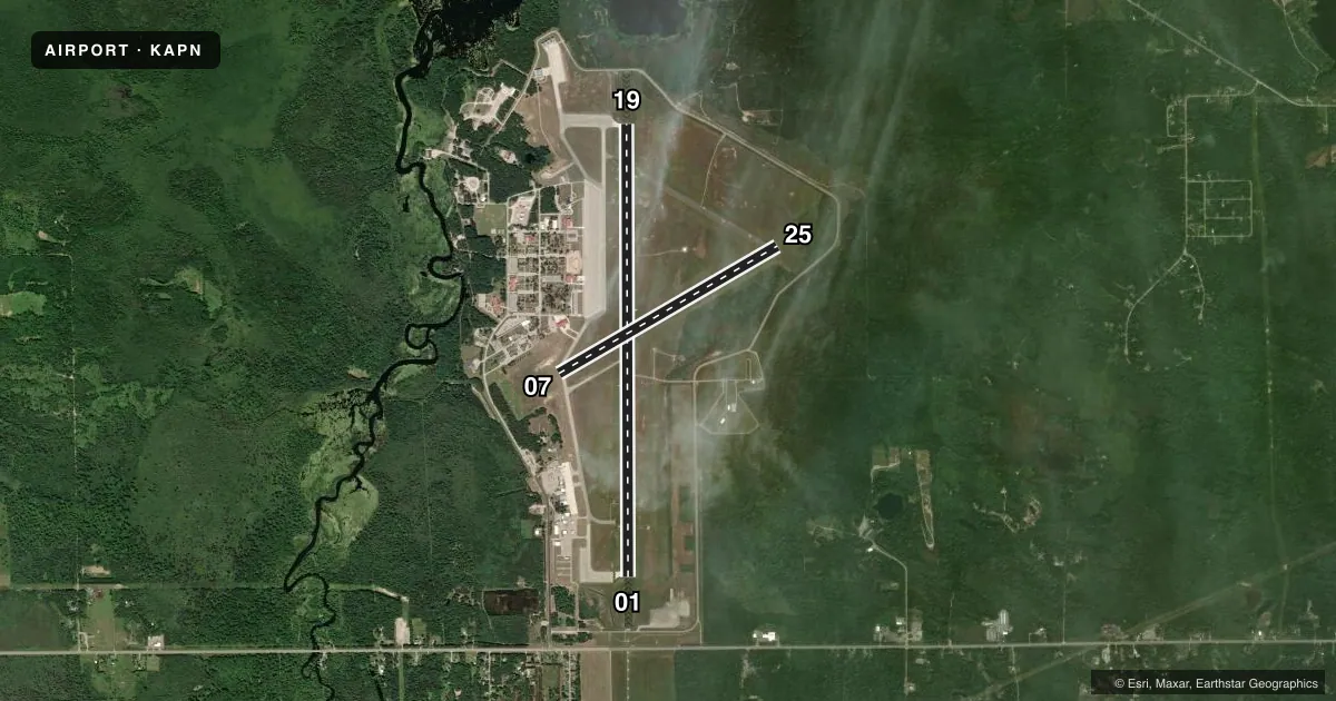
Runways & pattern
Full pagePattern entry · RWY 19
LEFT TRAFFIC| Runway | Heading (°M) | Length | Surface | Traffic |
|---|---|---|---|---|
| 01/19Favored | 353° / 173° | 9,001 ft | CONC | Standard L |
| 07/25 | 53° / 233° | 5,028 ft | CONC | Standard L |
Runway end performance
| End | TORA | TODA | ASDA | LDA | VGSI | Approach lights | Obstruction |
|---|---|---|---|---|---|---|---|
| 01 | 9,001' | 9,001' | 9,001' | 9,001' | PAPI 4-box left(3°) | MALSR | 68', tree, 3190' from thr, 329' R of cntrln, slope 43 |
| 19 | 9,001' | 9,001' | 9,001' | 9,001' | PAPI 4-box left(3°) | — | 56', tree, 2174' from thr, 440' R of cntrln, slope 35 |
| 07 | 5,028' | 5,028' | 5,028' | 5,028' | PAPI 4-box left(3°) | — | 46', trees, 1200' from thr, 0' R of cntrln, slope 21 |
| 25 | 5,028' | 5,028' | 5,028' | 5,028' | PAPI 4-box left(3°) | — | 80', trees, 2866' from thr, 427' R of cntrln, slope 33 |
Declared distances in feet. TORA = takeoff run available, TODA = takeoff distance, ASDA = accelerate-stop, LDA = landing distance.
Airport sketch
Runways drawn to scale from FAA survey coordinates, rendered over satellite imagery. Not for navigation.
Approaches & charts
ILS · 1
Services on the field
Fuel grades, oxygen, maintenance, ramp storage and lighting — as declared to the FAA by the airport operator.
Fuel & services
- Fuel
- 100LLA
- Oxygen (bottled)
- Not available
- Oxygen (bulk)
- Not available
- Airframe repair
- Minor
- Power plant repair
- Minor
- Other services
- CARGO,CHTR,INSTR,SALES
Ramp & ground
- Transient storage
- Tie-down
- Hangar
- Landing fee
- Yes
- Customs
- Not available
- Lighting schedule
- SEE RMK
- Beacon schedule
- SS-SR
- Beacon
- White / Green (civil land)(WG)
- Wind indicator
- Lighted
- Segmented circle
- Yes
Fuel & FBOs
Cheapest 100LL and Jet A on the field and nearby. Always confirm with the FBO before taxi.
Airport notes
Surface conditions, obstructions, local procedures, lighting outages and other notes published with each FAA cycle.
General notes
- RWY 01 & 19 EACH HAVE 1000 FT OVRN.
- BIRDS & OTR WILDLIFE ON & INVOF ARPT.
- MILITARY: ANG: DUTY HRS 0800-1600 MON-FRI EXC HOLS.
- TWY A WEST OF TWY C & TWY B RSTRD TO MIL ONLY. BE ALERT FOR UNCONTROLLED VEHICLES ON THE TWY.
- TWY H EAST OF RWY 01/19 UNLGTD.
- MILITARY: ANG: JOAP SER UNAVBL.
- FOR CD IF UNA TO CTC ON FSS FREQ, CTC MINNEAPOLIS ARTCC AT 651-463-5588.
- MILITARY: SER: FUEL A++.
Lighting notes
- ACTVT MALSR RWY 01; REIL RWY 19, 07, & 25; HIRL RWY 01/19; MIRL RWY 07/25 - CTAF.
Runway surface & condition
- 01/19TRT 560.
- 07/25TRT 560.
- 01/19PCR VALUE: 480/F/C/X/T
- 07/25RWY 07/25 NOT AVBL FOR PART 121/PART 380 OPS WITH SKED PAX CARRYING OPS MORE THAN 9 PAX SEATS AND NON-SKED PAX CARRYING OPS MORE THAN 30 PAX SEATS.
Arresting gear
- 01_BAK-12BAK-14 BAK-12A(B) (1500 FT).
- 19_BAK-12BAK-14 BAK-12A(B) (1515 FT).
Other notes
- 1FOR SER AFT HRS CALL 989-464-1419/989-255-4871.
VFR map & nearby airports
VFR sectional. Tap any ICAO chip to open that airport.
Key facts · KAPN
Answer card- ICAO
- KAPN
- Name
- ALPENA COUNTY RGNL
- Location
- ALPENA, MICHIGAN
- Elevation
- 689.5 ft MSL
- Traffic pattern altitude
- 1,689.5 ft MSL (1,000 AGL)
- Control tower
- Towered · 0800-1600 WKDAYS; EXCP HOLS (ANG).
- Total runways
- 2
- Longest runway
- 01/19 · 9,001 ft
- Published ILS approaches
- 1
- Published frequencies
- 13
- Magnetic variation
- 7°
- Current flight rules
- VFR
- Current wind
- 180° at 5 kt
- Favored runway now
- RWY 19
Alpena County Regional Airport sits in Alpena, Michigan on the Lake Huron side of the state. Field elevation is 689.5 ft MSL. The airport has 2 runways. Runway 01/19 is the longest at 9,001 ft. Runway 07/25 is 5,028 ft. The tower is open 0800-1600 weekdays except holidays. If you are planning a stop outside those hours, verify the current procedures before you go.
There is 1 ILS approach on runway 01. Pattern altitude is not published in the facts, so use the standard 1,000 ft AGL for light piston traffic unless the current Chart Supplement says otherwise. The on-field FBO is Alpena County Regional Airport. It carries 100LL and Jet A. The field notes also mention runway 01 has malfunctioning approach lighting with runway alignment indicator lights active. Runway 01/19 has high intensity runway lights. Runway 07/25 has medium intensity runway lights. Birds and other wildlife are reported on and near the airport, so keep a sharp scan on arrival and departure.
This is a towered field with military Air National Guard activity noted in the remarks. Runway 01 and 19 each have 1,000 ft of overrun. If you need after-hours service, the published remarks list phone numbers for contact. For anything operational that is not clear from the briefing here, check the current FAA Chart Supplement or call the airport operator directly.