METAR & TAF KAPA
Current METAR
Observed 05:53Z
KAPA 280553Z 25006KT 10SM FEW060 SCT120 23/14 A3018 RMK AO2 SLP132 60000 T02280144 10300 20222 55005 $
- Wind
- 250° @ 6 kt
- Visibility
- 10 SM
- Temp / Dew
- 23°C / 14°C
- Altimeter
- 30.18 inHg
- Clouds
- SCT
- Density alt
- 7,935 ft
- Ceiling
- Unlimited
- Rules
- VFR
Airport info & contacts
Manager on record, flight service, ARTCC, attendance schedule and pattern altitude — published by the FAA and refreshed every 28 days.
Location
- From city
- 15 NM SE
- VFR sectional
- DENVER
- ARTCC
- ZDV · DENVER
- NOTAM facility
- APA (NOTAM-D)
Airport manager
- Name
- MIKE FRONAPFEL
- Phone
- 303-790-0598
- Address
- 7565 SOUTH PEORIA ST, UNIT D9, ENGLEWOOD CO 80112
Flight service · Hours
- FSS DEN
- DENVER1-800-WX-BRIEF
- Attendance
- ALL
Frequencies
Tap any row to copy the frequency to your clipboard.
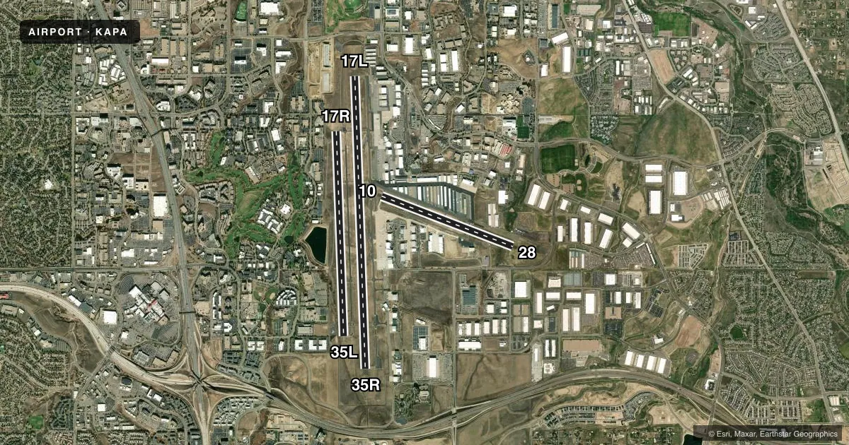
Runways & pattern
Full pagePattern entry · RWY 28
LEFT TRAFFIC| Runway | Heading (°M) | Length | Surface | Traffic |
|---|---|---|---|---|
| 17L/35R | 170° / 350° | 10,001 ft | ASPH | 35R R |
| 17R/35L | 170° / 350° | 7,001 ft | ASPH | 17R R |
| 10/28Favored | 103° / 283° | 4,800 ft | ASPH | Standard L |
Runway end performance
| End | TORA | TODA | ASDA | LDA | VGSI | Approach lights | Obstruction |
|---|---|---|---|---|---|---|---|
| 17L | — | — | — | — | PAPI 4-box left(3°) | — | — |
| 35R | — | — | — | — | PAPI 4-box left(3°) | MALSR | 542', pline, 17903' from thr, 2516' R of cntrln, slope 32 |
| 17R | — | — | — | — | PAPI 4-box left(3°) | — | — |
| 35L | — | — | — | — | PAPI 4-box right(3°) | — | 19', fence, 542' from thr, 267' R of cntrln, slope 18 |
| 10 | — | — | — | — | PAPI 2-box left(3°) | — | — |
| 28 | — | — | — | — | PAPI 2-box left(3°) | — | — |
Declared distances in feet. TORA = takeoff run available, TODA = takeoff distance, ASDA = accelerate-stop, LDA = landing distance.
Airport sketch
Runways drawn to scale from FAA survey coordinates, rendered over satellite imagery. Not for navigation.
Approaches & charts
ILS · 1
Services on the field
Fuel grades, oxygen, maintenance, ramp storage and lighting — as declared to the FAA by the airport operator.
Fuel & services
- Fuel
- 100LLAUL94
- Oxygen (bulk)
- HIGH/LOW
- Airframe repair
- Major
- Power plant repair
- Major
- Other services
- AMB,AVNCS,CHTR,INSTR,RNTL,SALES,SURV
Ramp & ground
- Transient storage
- Tie-down
- Hangar
- Landing fee
- No fee published
- Customs
- Not available
- Lighting schedule
- SS-SR
- Beacon schedule
- SS-SR
- Beacon
- White / Green (civil land)(WG)
- Wind indicator
- Lighted
- Segmented circle
- No
Fuel & FBOs
Cheapest 100LL and Jet A on the field and nearby. Always confirm with the FBO before taxi.
Airport notes
Surface conditions, obstructions, local procedures, lighting outages and other notes published with each FAA cycle.
General notes
- ALL ACFT BLO CERT 70000 LB MAX GROSS TKOF WT & STAGE III ACFT UP TO CERT 75000 LB MAX GROSS TKOF WT MAY OPR; ONE-TIME EXCEPTION AUZD BY EXEC DIR.
- WATERFOWL ON & INVOF ARPT.
- NMRS CRANES INVOF ARPT.
- +190 FT TWR LCTD 1800 FT ENE OF RY 17L THLD.
- HELI OPS CTC FBO FOR LNDG ZONE LCTN; HELI OPS ON FRONT RAMP NOT ADVISED.
- ADZY DENSITY ALT DSPL LCTD C-1, A-1 & A-18.
- CTN: ENSURE PROPER RWY ALNMT; CLOSE SPACED PARL RWYS. ARPT SAFETY VIDEO - HTTPS://WWW.FAA.GOV/AIRPORTS/RUNWAY_SAFETY/VIDEOS/APA/
- MULT LRG PWR LINES APRXLY 3NM S OF RWY 35R & RWY 35L.
- NOISE ABATEMENT PROCS IN EFCT. ALL ACFT AVOID NOISE SENSITIVE AREAS 1 NM NORTH AND WEST OF ARPT AND 1 NM SOUTHEAST OF ARPT. RWY 17R-35L CLSD TFC REMAIN SOUTH OF ARAPAHOE ROAD, EAST OF I-25, AND NORTH OF LINCOLN AVE. QUIET HRS 2200-0700L. TBJT ACFT USE NBAA PROFILES. NOISE OFFICE/303-790-0598.
- +71 FT BLDG LCTD 1920 FT ESE OF RY 28 THLD 440 FT LT OF CTLN 24:1 GLD SLP.
Fuel notes
- 100LLSELF SERVE FUEL AVBL.
Runway surface & condition
- 17R/35LPCR VALUE: 339/F/C/X/T
- H1TLOF 50X50 FT; FATO 50X50 FT; INGRESS/EGRESS 270.
Approach & departure obstructions
- 17LNMRS FLOOD LGTS 1/2 SM N OF THR; SS-2400.
- H1H24 HELI SVC - 303-799-0079.
Other notes
- H24 US CUSTOMS - 303-768-0309.
- OWNERAFT HR - 303-877-7307.
VFR map & nearby airports
VFR sectional. Tap any ICAO chip to open that airport.
Key facts · KAPA
Answer card- ICAO
- KAPA
- Name
- CENTENNIAL
- Location
- DENVER, COLORADO
- Elevation
- 5,884.9 ft MSL
- Traffic pattern altitude
- 6,884.9 ft MSL (1,000 AGL)
- Control tower
- Towered · 24
- Total runways
- 3
- Longest runway
- 17L/35R · 10,001 ft
- Published ILS approaches
- 1
- Published frequencies
- 8
- Magnetic variation
- 8°
- Current flight rules
- VFR
- Current wind
- 250° at 6 kt
- Favored runway now
- RWY 28
Centennial Airport sits in Denver, Colorado. Field elevation is 5,884.9 ft MSL. The airport has 3 asphalt runways. The longest is runway 17L/35R at 10,001 ft. The tower is open 24 hours. One ILS is published for runway 35R. Pattern altitude is not published, so use the standard 1,000 ft AGL for light piston unless the current Chart Supplement says otherwise.
This is a busy high-elevation field. Expect performance to matter on warm days. Noise abatement is active. Aircraft must stay clear of the noise-sensitive areas north and west of the airport. They must also avoid the southeast side. Traffic must remain south of Arapahoe Road. It must remain east of Interstate 25. It must remain north of Lincoln Avenue. Quiet hours run from 2200 to 0700 local. Runway 17R/35L is closed to traffic. The published remarks also note a +190 ft tower near the 17L threshold area and a +71 ft building near the runway 28 approach path, so brief carefully on departure and arrival.
On the field, Signature Aviation - South, Modern Aviation, Signature Aviation - North, jetCenters of Colorado and AirCam Helicopters at The Heliplex are listed. Signature, Modern and jetCenters carry 100LL and Jet A. jetCenters also carries UL94. AirCam Helicopters carries Jet A Prist. Self-serve 100LL is available. Waterfowl are reported on and near the airport. If you are planning helicopter work, call ahead for the landing zone. Front ramp helicopter ops are not advised.