METAR & TAF KALW
Current METAR
Observed 15:53Z
KALW 271553Z 24005KT 10SM CLR 23/05 A3005 RMK AO2 SLP169 T02280050
- Wind
- 240° @ 5 kt
- Visibility
- 10 SM
- Temp / Dew
- 23°C / 5°C
- Altimeter
- 30.05 inHg
- Clouds
- CLR
- Density alt
- 2,280 ft
- Ceiling
- Unlimited
- Rules
- VFR
Airport info & contacts
Manager on record, flight service, ARTCC, attendance schedule and pattern altitude — published by the FAA and refreshed every 28 days.
Location
- From city
- 3 NM NE
- VFR sectional
- SEATTLE
- ARTCC
- ZSE · SEATTLE
- NOTAM facility
- ALW (NOTAM-D)
Airport manager
- Name
- JENNIFER SKOGLUND
- Phone
- 509-525-3100
- Address
- 45 TERMINAL LOOP RD., SUITE 210, WALLA WALLA WA 99362
Flight service · Hours
- FSS SEA
- SEATTLE1-800-WX-BRIEF
- Attendance
- 0800-1800
Frequencies
Tap any row to copy the frequency to your clipboard.
Runways & pattern
Full pagePattern entry · RWY 20
LEFT TRAFFICRunway end performance
| End | TORA | TODA | ASDA | LDA | VGSI | Approach lights | Obstruction |
|---|---|---|---|---|---|---|---|
| 02 | 6,527' | 6,527' | 6,527' | 6,527' | PAPI 4-box left(3°) | — | — |
| 20 | 6,527' | 6,527' | 6,527' | 6,527' | PAPI 4-box left(3°) | MALSR | — |
Declared distances in feet. TORA = takeoff run available, TODA = takeoff distance, ASDA = accelerate-stop, LDA = landing distance.
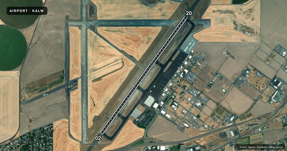
Airport sketch
Runways drawn to scale from FAA survey coordinates, rendered over satellite imagery. Not for navigation.
Approaches & charts
ILS · 1
Services on the field
Fuel grades, oxygen, maintenance, ramp storage and lighting — as declared to the FAA by the airport operator.
Fuel & services
- Fuel
- 100LLA
- Oxygen (bulk)
- Low pressure
- Airframe repair
- Major
- Power plant repair
- Major
- Other services
- AFRT,AGRI,AMB,CARGO,CHTR,INSTR,RNTL,SALES
Ramp & ground
- Transient storage
- Tie-down
- Hangar
- Landing fee
- No fee published
- Customs
- Not available
- Lighting schedule
- SEE RMK
- Beacon schedule
- SS-SR
- Beacon
- White / Green (civil land)(WG)
- Wind indicator
- Lighted
- Segmented circle
- No
Fuel & FBOs
Cheapest 100LL and Jet A on the field and nearby. Always confirm with the FBO before taxi.
Airport notes
Surface conditions, obstructions, local procedures, lighting outages and other notes published with each FAA cycle.
General notes
- SFC CONDS UNMON 0000-0300.
- 24 HR FUEL SVC CALL 509-540-1081.
- PTN OF CORNER AT TWY A & TWY A1 NOT VSB BY TWR.
- FOR CD WHEN ALW ATC IS CLSD CTC SPOKANE APCH AT 509-742-2525. WHEN APCH CLSD CTC SEATTLE ARTCC AT 253-351-3694
- CTC AMGR 509-525-3100 FOR ARNGMT FOR RAMP PRKG OF 175,000 LB MTOW
- TWY A,A1,A2,A3,A4,A5 OPEN TO AIR CARRIERS.
Lighting notes
- WHEN ATCT CLSD ACTVT MALSR RY 20, REIL RY 02 & HIRL RY 02/20 - CTAF.
Fuel notes
- 100LLSELF SVC CREDIT CARD FUELING FACILITY LCTD 600 FT N OF ATCT.
Runway surface & condition
- 02/20PCR VALUE: 340/F/D/X/T
Other notes
- ESTABD PRIOR TO MAY 1959.
- ARFF SVCS AVBL DURING SCHEDULED ACR OPS. CLSD TO UNSKED ACR OPNS WITH MORE THAN 30 PSGR SEATS EXCP PPR CALL AMGR 509-525-3100.
VFR map & nearby airports
VFR sectional. Tap any ICAO chip to open that airport.
Key facts · KALW
Answer card- ICAO
- KALW
- Name
- WALLA WALLA RGNL
- Location
- WALLA WALLA, WASHINGTON
- Elevation
- 1,194.4 ft MSL
- Traffic pattern altitude
- 2,194.4 ft MSL (1,000 AGL)
- Control tower
- Towered · 0600-1830
- Total runways
- 1
- Longest runway
- 02/20 · 6,527 ft
- Published ILS approaches
- 1
- Published frequencies
- 8
- Magnetic variation
- 14°
- Current flight rules
- VFR
- Current wind
- 240° at 5 kt
- Favored runway now
- RWY 20
Walla Walla Rgnl is in Walla Walla, Washington. The field elevation is 1,194.4 ft MSL. It has one runway, 02/20, which is 6,527 ft long and paved concrete. The tower is open from 0600 to 1830. Runway 20 has the ILS approach. Pattern altitude is not published in the facts, so use the standard 1,000 ft AGL for light piston traffic unless the current FAA Chart Supplement says otherwise.
Gorge Aviation Services is on the field. It carries 100LL, Jet A and Jet A Prist. Self-serve credit card fueling is available 600 ft north of the tower. Twenty-four hour fuel service is also available by calling the FBO directly. When the tower is closed, use CTAF 118.5 for lighting activation. The published remarks also note that surface conditions are unmonitored from 0000 to 0300.
This is a towered airport with Spokane Approach handling clearance delivery when Walla Walla tower is closed. The airport sits in a valley setting with a single long runway, so plan for normal pattern work and watch your taxi situational awareness. The tower cannot see the corner at taxiway A and taxiway A1. Check the current FAA Chart Supplement for any noise or curfew restrictions before flying in.