METAR & TAF KAKR
Current METAR
Observed 19:54Z
KAKR 271954Z AUTO 25010KT 10SM CLR 29/19 A2983 RMK AO2 SLP091 T02890194
- Wind
- 250° @ 10 kt
- Visibility
- 10 SM
- Temp / Dew
- 29°C / 19°C
- Altimeter
- 29.83 inHg
- Clouds
- CLR
- Density alt
- 3,115 ft
- Ceiling
- Unlimited
- Rules
- VFR
Airport info & contacts
Manager on record, flight service, ARTCC, attendance schedule and pattern altitude — published by the FAA and refreshed every 28 days.
Location
- From city
- 4 NM SE
- VFR sectional
- DETROIT
- ARTCC
- ZOB · CLEVELAND
- NOTAM facility
- AKR (NOTAM-D)
Airport manager
- Name
- ANTHONY PLUCINSKI
- Phone
- 330-733-4760
- Address
- 1600 TRIPLETT BLVD, AKRON OH 44306-3308
Flight service · Hours
- FSS CLE
- CLEVELAND1-800-WX-BRIEF
- Attendance
- MON-FRI · 0600-2200
- SAT-SUN · 0800-2000
Frequencies
Tap any row to copy the frequency to your clipboard.
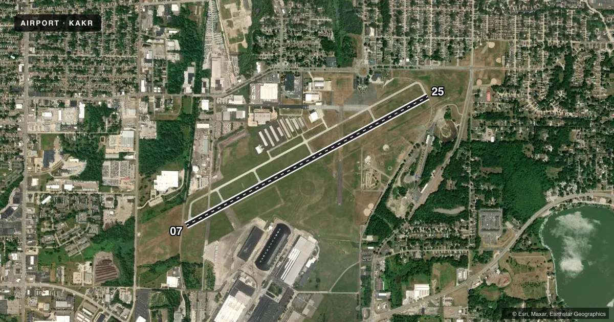
Runways & pattern
Full pagePattern entry · RWY 25
LEFT TRAFFICRunway end performance
| End | TORA | TODA | ASDA | LDA | VGSI | Approach lights | Obstruction |
|---|---|---|---|---|---|---|---|
| 07 | — | — | — | — | PAPI 4-box left(3.6°) | — | 23', rr, 201' from thr, 140' R of cntrln, slope 1 |
| 25 | — | — | — | — | PAPI 4-box left(4°) | — | 125', tree, 1078' from thr, 427' R of cntrln, slope 7 |
Declared distances in feet. TORA = takeoff run available, TODA = takeoff distance, ASDA = accelerate-stop, LDA = landing distance.
Airport sketch
Runways drawn to scale from FAA survey coordinates, rendered over satellite imagery. Not for navigation.
Approaches & charts
ILS · 1
Services on the field
Fuel grades, oxygen, maintenance, ramp storage and lighting — as declared to the FAA by the airport operator.
Fuel & services
- Fuel
- 100LLA
- Oxygen (bottled)
- Not available
- Oxygen (bulk)
- HIGH/LOW
- Airframe repair
- Major
- Power plant repair
- Major
- Other services
- AMB,CHTR,INSTR,RNTL
Ramp & ground
- Transient storage
- Tie-down
- Hangar
- Landing fee
- No fee published
- Customs
- Not available
- Lighting schedule
- SEE RMK
- Beacon schedule
- SEE RMK
- Beacon
- White / Green (civil land)(WG)
- Wind indicator
- Lighted
- Segmented circle
- No
Fuel & FBOs
Cheapest 100LL and Jet A on the field and nearby. Always confirm with the FBO before taxi.
Airport notes
Surface conditions, obstructions, local procedures, lighting outages and other notes published with each FAA cycle.
General notes
- FOR CD CTC CLEVELAND APCH AT 216-352-2323, WHEN APCH CLSD CTC CLEVELAND ARTCC AT 440-774-0223/0490.
- DEER ON & INVOF ARPT.
Lighting notes
- ARPT BCN OPRS CONSLY.
- ACTVT REIL RWY 07 & 25; PAPI RWY 07 & 25; MIRL RWY 07/25 - CTAF.
Approach & departure obstructions
- 0723 FT RAILROAD 0-200 FT FM, 155 FT L TO 140 FT RIGHT.
- 25APCH RATIO 12:1 TO DSPLCD THR DUE TO +108 FT TREE 1310 FT FM THR 422 FT RIGHT.
Other notes
- PRIOR CDN RQRD.
- MANAGERTONYP@SUMMITAIRPORTSERVICES.COM.
VFR map & nearby airports
VFR sectional. Tap any ICAO chip to open that airport.
Key facts · KAKR
Answer card- ICAO
- KAKR
- Name
- AKRON FULTON INTL
- Location
- AKRON, OHIO
- Elevation
- 1,067.3 ft MSL
- Traffic pattern altitude
- 2,067.3 ft MSL (1,000 AGL)
- Control tower
- Non-towered (use CTAF)
- Total runways
- 1
- Longest runway
- 07/25 · 6,336 ft
- Published ILS approaches
- 1
- Published frequencies
- 5
- Magnetic variation
- 7°
- Current flight rules
- VFR
- Current wind
- 250° at 10 kt
- Favored runway now
- RWY 25
Akron Fulton Intl is in Akron, Ohio. The field elevation is 1,067.3 ft MSL. It has one runway, 07/25. The longest runway is 6,336 ft. There is no control tower. Cleveland Approach handles clearance delivery and approach services. The published traffic pattern altitude is not listed, so use the standard 1,000 ft AGL pattern unless the current Chart Supplement says otherwise. That puts the light piston pattern at about 2,067 ft MSL.
Runway 25 has an ILS approach. Runway 07 and runway 25 both have PAPI, runway end identifier lights and medium intensity runway lighting that is controlled by CTAF. The airport beacon operates continuously. Summit Airport Services is on the field. It carries 100LL and Jet A. Prior coordination is required. The published remarks also call out deer on and near the airport. Plan for wildlife on taxi, takeoff and landing.
There are a couple of obstacle notes that matter on final. Runway 25 has a tree near the approach path. Runway 07 has a railroad close to the threshold. If you are new to the field, brief the approach carefully. Check the current Chart Supplement before you go. The remarks also list Cleveland Approach and Cleveland ARTCC phone numbers for clearance delivery when needed.