METAR & TAF KAID
Current METAR
Observed 12:15Z
KAID 271215Z AUTO 00000KT M1/4SM FG OVC003 22/22 A2994 RMK AO2 T02160216
- Wind
- 000° @ 0 kt
- Visibility
- —
- Temp / Dew
- 22°C / 22°C
- Altimeter
- 29.94 inHg
- Clouds
- OVC
- Density alt
- 1,955 ft
- Ceiling
- 300 ft AGL
- Rules
- LIFR
Airport info & contacts
Manager on record, flight service, ARTCC, attendance schedule and pattern altitude — published by the FAA and refreshed every 28 days.
Location
- From city
- 3 NM E
- VFR sectional
- CHICAGO
- ARTCC
- ZID · INDIANAPOLIS
- NOTAM facility
- AID (NOTAM-D)
Airport manager
- Name
- BRIAN MCMILLEN
- Phone
- 765-648-6292
- Address
- 282 AIRPORT RD., ANDERSON IN 46017
Flight service · Hours
- FSS HUF
- TERRE HAUTE1-800-WX-BRIEF
- Attendance
- MON-FRI · 0700-1800
- SAT-SUN · ON CALL
Frequencies
Tap any row to copy the frequency to your clipboard.
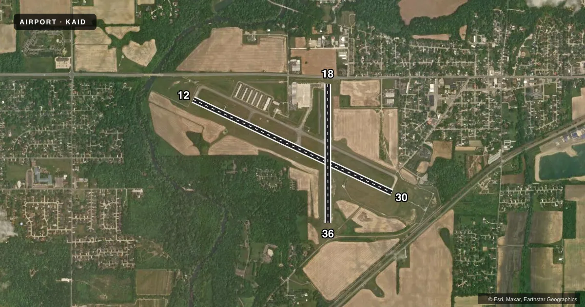
Runways & pattern
Full pagePattern entry · RWY 12
LEFT TRAFFIC| Runway | Heading (°M) | Length | Surface | Traffic |
|---|---|---|---|---|
| 12/30 | 112° / 292° | 5,400 ft | ASPH | Standard L |
| 18/36 | 177° / 357° | 3,399 ft | ASPH | Standard L |
Runway end performance
| End | TORA | TODA | ASDA | LDA | VGSI | Approach lights | Obstruction |
|---|---|---|---|---|---|---|---|
| 12 | — | — | — | — | PAPI 4-box left(3°) | — | 117', trees, 1831' from thr, 519' R of cntrln, slope 13 |
| 30 | — | — | — | — | PAPI 4-box left(3°) | MALSF | 50', trees, 1700' from thr, 30' R of cntrln, slope 30 |
| 18 | — | — | — | 3,108' | PAPI 2-box left(3°) | — | 63', tree, 1314' from thr, 134' R of cntrln, slope 17 |
| 36 | — | — | — | 3,111' | — | — | 98', trees, 1900' from thr, 100' R of cntrln, slope 17 |
Declared distances in feet. TORA = takeoff run available, TODA = takeoff distance, ASDA = accelerate-stop, LDA = landing distance.
Airport sketch
Runways drawn to scale from FAA survey coordinates, rendered over satellite imagery. Not for navigation.
Approaches & charts
ILS · 1
Services on the field
Fuel grades, oxygen, maintenance, ramp storage and lighting — as declared to the FAA by the airport operator.
Fuel & services
- Fuel
- 100LLAMOGAS
- Oxygen (bulk)
- Not available
- Airframe repair
- Major
- Power plant repair
- Major
- Other services
- AFRT,CHTR,INSTR,RNTL,SALES
Ramp & ground
- Transient storage
- Tie-down
- Hangar
- Landing fee
- No fee published
- Customs
- Not available
- Lighting schedule
- SEE RMK
- Beacon schedule
- SS-SR
- Beacon
- White / Green (civil land)(WG)
- Wind indicator
- Lighted
- Segmented circle
- Yes
Fuel & FBOs
Cheapest 100LL and Jet A on the field and nearby. Always confirm with the FBO before taxi.
Airport notes
Surface conditions, obstructions, local procedures, lighting outages and other notes published with each FAA cycle.
General notes
- DEP RWY 12, 18 & 36 UN TO SEE EACH OTHER.
- DEER ON & INVOF ARPT.
- TWY B CLSD INDEFLY.
- WHEN ATCT IS CLSD FOR CD CTC INDIANAPOLIS APCH AT 317-227-5743.
- GND COM OUTLET 121.725 COMMISSIONED KEY FREQ 4 TIMES.
- TRML NOT STAFFED ON SUNDAYS - AMGR.
- SELF SERVE FUEL AVBL H24.
Lighting notes
- WHEN TWR CLSD ACTVT MALSF RWY 30; PAPI RWY 12 & 18; MIRL RWY 12/30 & 18/36 - CTAF.
Runway surface & condition
- 18/36NOT AVBL TO ACR MORE THAN 30 PAX SEATS.
Approach & departure obstructions
- 1811 FT RD 170 FT FM RWY END.
- 18APCH RATIO 24:1 TO DSPLCD THR.
- 30APCH RATIO 35:1 TO DSPLCD THR.
- 36APCH RATIO 22:1 TO DSPLCD THR.
Other notes
- 3UNATNDD MARTIN LUTHER KING, PRES, ELECTION, EASTER, MEMORIAL, INDEPENDENCE, LABOR, VETERANS, THANKSGIVING, CHRISTMAS, NEW YEARS DAYS & GOOD FRIDAY; AFT HR - AMGR.
VFR map & nearby airports
VFR sectional. Tap any ICAO chip to open that airport.
Key facts · KAID
Answer card- ICAO
- KAID
- Name
- ANDERSON RGNL
- Location
- ANDERSON, INDIANA
- Elevation
- 919.1 ft MSL
- Traffic pattern altitude
- 1,919.1 ft MSL (1,000 AGL)
- Control tower
- Towered · 0830-1630 MON-SAT
- Total runways
- 2
- Longest runway
- 12/30 · 5,400 ft
- Published ILS approaches
- 1
- Published frequencies
- 6
- Magnetic variation
- 3°
- Current flight rules
- LIFR
- Current wind
- 000° at 0 kt
- Favored runway now
- –
Anderson Regional Airport sits in Anderson, Indiana. The field elevation is 919.1 ft MSL. It has two asphalt runways. The longest is runway 12/30 at 5,400 ft. Runway 18/36 is 3,399 ft. The airport is towered. Tower hours are 0830-1630 Monday through Saturday.
There is one ILS approach. It serves runway 30. Pattern altitude is not published in the facts. Use the standard 1,000 ft AGL for light piston operations unless the current Chart Supplement says otherwise. On the field, Anderson Regional Airport carries 100LL, Jet A Prist and MOGAS. Self-serve fuel is available 24 hours a day. The terminal is not staffed on Sundays. After hours, contact the airport manager.
A few local items matter here. Taxiway B is closed indefinitely. Deer are on and in the vicinity of the airport. Departures from runways 12, 18 and 36 cannot see each other. Runway 30 has a displaced threshold with a published 35:1 approach ratio. Runway 18 also has a displaced threshold. When the tower is closed for clearance delivery, contact Indianapolis Approach. If you are planning a first stop here, brief the runway layout and the tower hours before you go. Check the current Chart Supplement for any published noise or curfew restrictions before flying into the field.