METAR & TAF KAEG
Current METAR
Observed 17:50Z
KAEG 271750Z 21005KT 10SM CLR 32/11 A3021
- Wind
- 210° @ 5 kt
- Visibility
- 10 SM
- Temp / Dew
- 32°C / 11°C
- Altimeter
- 30.21 inHg
- Clouds
- CLR
- Density alt
- 8,919 ft
- Ceiling
- Unlimited
- Rules
- VFR
Airport info & contacts
Manager on record, flight service, ARTCC, attendance schedule and pattern altitude — published by the FAA and refreshed every 28 days.
Location
- From city
- 7 NM NW
- VFR sectional
- ALBUQUERQUE
- ARTCC
- ZAB · ALBUQUERQUE
- NOTAM facility
- AEG (NOTAM-D)
Airport manager
- Name
- GAVINO GALLEGOS
- Phone
- 505-259-8113
- Address
- PO BOX 9948, ALBUQUERQUE NM 87119
Flight service · Hours
- FSS ABQ
- ALBUQUERQUE1-800-WX-BRIEF
- Attendance
- 0600-1900
Frequencies
Tap any row to copy the frequency to your clipboard.
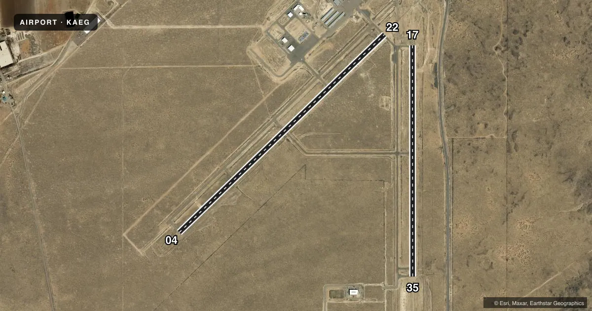
Runways & pattern
Full pagePattern entry · RWY 22
RIGHT TRAFFIC| Runway | Heading (°M) | Length | Surface | Traffic |
|---|---|---|---|---|
| 04/22Favored | 35° / 215° | 7,398 ft | ASPH | 22 R |
| 17/35 | 169° / 349° | 5,983 ft | ASPH | 35 R |
Runway end performance
| End | TORA | TODA | ASDA | LDA | VGSI | Approach lights | Obstruction |
|---|---|---|---|---|---|---|---|
| 04 | — | — | — | — | PAPI 4-box left(3°) | — | — |
| 22 | — | — | — | — | — | MALSR | — |
| 17 | — | — | — | — | PAPI 4-box left(3°) | — | — |
Declared distances in feet. TORA = takeoff run available, TODA = takeoff distance, ASDA = accelerate-stop, LDA = landing distance.
Airport sketch
Runways drawn to scale from FAA survey coordinates, rendered over satellite imagery. Not for navigation.
Approaches & charts
ILS · 1
Services on the field
Fuel grades, oxygen, maintenance, ramp storage and lighting — as declared to the FAA by the airport operator.
Fuel & services
- Fuel
- 100LLA1
- Oxygen (bottled)
- High pressure
- Oxygen (bulk)
- High pressure
- Airframe repair
- Major
- Power plant repair
- Major
- Other services
- AMB,CHTR,INSTR,RNTL
Ramp & ground
- Transient storage
- Tie-down
- Hangar
- Lighting schedule
- SEE RMK
- Beacon schedule
- SS-SR
- Beacon
- White / Green (civil land)(WG)
- Wind indicator
- Lighted
- Segmented circle
- Yes
Fuel & FBOs
Cheapest 100LL and Jet A on the field and nearby. Always confirm with the FBO before taxi.
Airport notes
Surface conditions, obstructions, local procedures, lighting outages and other notes published with each FAA cycle.
General notes
- WILDLIFE ON AND INVOF ARPT.
- LIVE FIRE RANGE 1.6NM WEST OF THE APPROACH END OF RWY 04 AVOIDANCE ADVISED.
Lighting notes
- ACTVT MALSR RWY 22; REIL RWY 17 & 35; PAPI RWY 04 & 17; MIRL RWY 04/22 & 17/35 - CTAF.
Fuel notes
- 100LL100LL AVBL 24 HRS SELF-SERVICE WITH MAJOR CREDIT CARD.
- A1$150 CALL-OUT FEE FOR JET A1.
Other notes
- CALL AHEAD FOR AVAILABILITY 505-352-0292.
- 1FOR ATTENDANT AFT HRS CALL 505-884-4530.
VFR map & nearby airports
VFR sectional. Tap any ICAO chip to open that airport.
Key facts · KAEG
Answer card- ICAO
- KAEG
- Name
- DOUBLE EAGLE II
- Location
- ALBUQUERQUE, NEW MEXICO
- Elevation
- 5,837.4 ft MSL
- Traffic pattern altitude
- 6,837.4 ft MSL (1,000 AGL)
- Control tower
- Towered · 0600-2200
- Total runways
- 2
- Longest runway
- 04/22 · 7,398 ft
- Published ILS approaches
- 1
- Published frequencies
- 7
- Magnetic variation
- 11°
- Current flight rules
- VFR
- Current wind
- 210° at 5 kt
- Favored runway now
- RWY 22
Double Eagle II is in Albuquerque, New Mexico. Field elevation is 5,837.4 ft MSL. The airport has 2 asphalt runways. The longest is 7,398 ft on 04/22. The tower is open from 0600 to 2200. Runway 22 has the ILS. Pattern altitude is not published, so use the standard 1,000 ft AGL for light piston traffic unless the current Chart Supplement says otherwise.
Bode Aviation is on the field. It carries 100LL and Jet A. 100LL is available 24 hours self-service with a major credit card. Call ahead for availability before you go. There is also a live fire range 1.6 NM west of the approach end of runway 04. Plan your arrival with that in mind. Wildlife has been reported on and near the airport.
The field sits in the Albuquerque area at high elevation. Expect density altitude to matter, especially on warm days. The airport also has runway lighting on both runways. MALSR is installed for runway 22. PAPI is installed on runways 04 and 17. REIL is installed on runways 17 and 35. Use CTAF for communications when needed. If you need current noise, curfew, or airspace details, check the current FAA Chart Supplement before departure.