METAR & TAF KADS
Current METAR
Observed 06:55Z
KADS 280655Z AUTO 18006G16KT 150V220 10SM CLR 31/21 A2986 RMK AO2
- Wind
- 180° @ 6G16 kt
- Visibility
- 10 SM
- Temp / Dew
- 31°C / 21°C
- Altimeter
- 29.86 inHg
- Clouds
- CLR
- Density alt
- 2,793 ft
- Ceiling
- Unlimited
- Rules
- VFR
Airport info & contacts
Manager on record, flight service, ARTCC, attendance schedule and pattern altitude — published by the FAA and refreshed every 28 days.
Location
- From city
- 9 NM N
- VFR sectional
- DALLAS-FT WORTH
- Pattern altitude
- 956 ft AGL · 1,600 ft MSL
- ARTCC
- ZFW · FORT WORTH
- NOTAM facility
- ADS (NOTAM-D)
Airport manager
- Name
- JAIME EDROSA
- Phone
- 972-392-4850
- Address
- 4545 JIMMY DOOLITTLE DRIVE, SUITE 200, ADDISON TX 75001
Flight service · Hours
- FSS FTW
- FORT WORTH1-800-WX-BRIEF
- Attendance
- 0600-2200
Frequencies
Tap any row to copy the frequency to your clipboard.
Runways & pattern
Full pagePattern entry · RWY 16
LEFT TRAFFICRunway end performance
| End | TORA | TODA | ASDA | LDA | VGSI | Approach lights | Obstruction |
|---|---|---|---|---|---|---|---|
| 16 | 7,203' | 7,203' | 7,203' | 6,224' | PAPI 4-box right(3°) | MALSR | 10', road, 200' from thr, 500' R of cntrln, slope 0 |
| 34 | 7,203' | 7,203' | 7,203' | 6,431' | PAPI 4-box left(3°) | — | 10', road, 200' from thr, 500' R of cntrln, slope 0 |
Declared distances in feet. TORA = takeoff run available, TODA = takeoff distance, ASDA = accelerate-stop, LDA = landing distance.
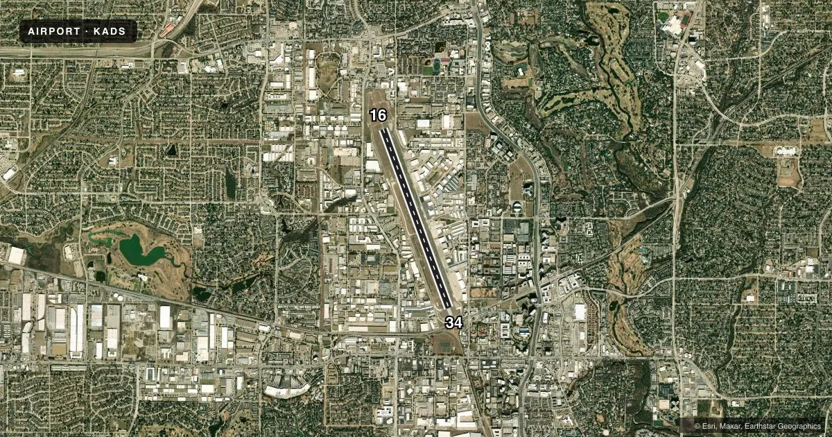
Airport sketch
Runways drawn to scale from FAA survey coordinates, rendered over satellite imagery. Not for navigation.
Approaches & charts
ILS · 2
Services on the field
Fuel grades, oxygen, maintenance, ramp storage and lighting — as declared to the FAA by the airport operator.
Fuel & services
- Fuel
- 100LLA
- Oxygen (bottled)
- High pressure
- Oxygen (bulk)
- Low pressure
- Airframe repair
- Major
- Power plant repair
- Major
- Other services
- AVNCS,CHTR,INSTR,RNTL,SALES,SURV
Ramp & ground
- Transient storage
- Tie-down
- Hangar
- Landing fee
- No fee published
- Customs
- Not available
- Lighting schedule
- SEE RMK
- Beacon schedule
- SS-SR
- Beacon
- White / Green (civil land)(WG)
- Wind indicator
- Lighted
- Segmented circle
- Yes
Fuel & FBOs
Cheapest 100LL and Jet A on the field and nearby. Always confirm with the FBO before taxi.
Airport notes
Surface conditions, obstructions, local procedures, lighting outages and other notes published with each FAA cycle.
General notes
- NUMEROUS 200 FT BLDGS WITHIN 1 MILE EAST AND SOUTH OF ARPT; TRANSMISSION TOWERS AND WATER TANKS WEST OF ARPT.
- NO TGL WITHOUT AMGR APPROVAL.
- USER FEE ARPT. CPB OFC HRS M-F 1000-2100. 214-208-3636.
- BIRDS ON & INVOF ARPT.
- BE ALERT: RWY HLDG PTN MRKGS LCTD AT THE WEST EDGE OF TWY A.
- NOISE SENSITIVE AREAS SURROUND ARPT. PILOTS REQUESTED TO USE NBAA STD NOISE ABATEMENT PROCEDURES.
- AWOS-3 INFO ONLY AVBL WHEN ATCT CLSD. ATIS AVBL DURING TWR HRS.
Lighting notes
- ACTVT MALSR RWY 16; HIRL RWY 16/34 - CTAF.
Approach & departure obstructions
- 1610 FT ARPT PERIMETER RD, 0-200 FT DSTC, 275 FT R, 488 FT L
- 3410 FT ARPT PERIMETER RD, 0-200 FT DSTC, 320 FT L TO 460 FT R.
- 16APCH SLOPE 10:1 TO DSPLCD THR OVR 40 FT TREE, 430 FT DSTC, 475 FT L.
- 34APCH SLOPE 17:1 TO DSPLCD THR OVR 28 FT POLE, 490 FT DSTC, 536 FT L.
- 34ANTENNA ON TOP OF BLDG.
Arresting gear
- 16_EMASEMAS NON-STD ARRESTING GEAR/SYSTEM: ENGINEERED MATERIALS ARRESTING SYSTEM (EMAS) 387 FT IN LENGTH BY 100 FT WIDTH LCTD 35 FT SETBACK FM DER 16.
Other notes
- TPA: 956 FT AGL LIGHT ACFT, 1356 FT AGL LRG ACFT.
VFR map & nearby airports
VFR sectional. Tap any ICAO chip to open that airport.
Key facts · KADS
Answer card- ICAO
- KADS
- Name
- ADDISON
- Location
- DALLAS, TEXAS
- Elevation
- 644.2 ft MSL
- Traffic pattern altitude
- 1,600.2 ft MSL (956 AGL)
- Control tower
- Towered · 0600-2200
- Total runways
- 1
- Longest runway
- 16/34 · 7,203 ft
- Published ILS approaches
- 2
- Published frequencies
- 9
- Magnetic variation
- 3°
- Current flight rules
- VFR
- Current wind
- 180° at 6 kt
- Favored runway now
- RWY 16
Addison Airport sits in Dallas, Texas. Field elevation is 644.2 ft MSL. The airport has one runway. Runway 16/34 is 7,203 ft long and asphalt. The tower is open daily from 0600 to 2200. ATIS is available during tower hours. When the tower is closed, only AWOS-3 information is available.
Two ILS approaches are published. They serve runway ends 16 and 34. Pattern altitude is 956 ft AGL, or 1,600.2 ft MSL. That is the number to brief, not a computed value.
Three on-field FBOs are listed. Atlantic Aviation carries 100LL and Jet A. Galaxy FBO carries 100LL and Jet A Prist. Million Air carries 100LL, Jet A and Jet A Prist. This is a user fee airport. Check with the airport operator or the FBO directly for current access details before you go.
First-time visitors should pay close attention to the noise environment. Noise sensitive areas surround the field. NBAA standard noise abatement procedures are requested. There are also several published obstacles near both runway ends. Runway 16 has a non-standard EMAS at the departure end. Runway 34 has nearby roads, an antenna near the end and a pole on the extended approach path. Birds are also reported on and near the airport. Expect a busy metro airport with towered operations. Plan your arrival accordingly.