METAR & TAF 97M
97M does not publish a METAR.
Showing the nearest reporting station: KBHK (BAKER MUNI) · 30.5 NM away. Conditions at 97M may differ.
METAR · KBHK
Observed 05:51Z
KBHK 120551Z AUTO 36003KT 10SM SCT090 10/07 A2996 RMK AO2 SLP139 T01000072 10194 20100 51008
- Wind
- 360° @ 3 kt
- Visibility
- 10 SM
- Temp / Dew
- 10°C / 7°C
- Altimeter
- 29.96 inHg
- Clouds
- SCT
- Density alt
- 3,696 ft
- Ceiling
- Unlimited
- Rules
- VFR
Airport info & contacts
Manager on record, flight service, ARTCC, attendance schedule and pattern altitude — published by the FAA and refreshed every 28 days.
Location
- From city
- 2 NM SE
- VFR sectional
- BILLINGS
- ARTCC
- ZLC · SALT LAKE CITY
- NOTAM facility
- GTF (NOTAM-D)
Airport manager
- Name
- TROY FRUIT
- Phone
- 406-853-5377
- Address
- PO BOX 315, EKALAKA MT 59324
Flight service · Hours
- FSS GTF
- GREAT FALLS1-800-WX-BRIEF
- Attendance
- Unattended
Frequencies
Tap any row to copy the frequency to your clipboard.
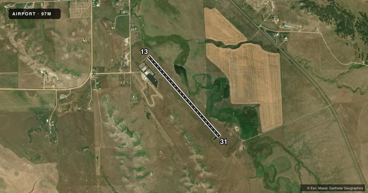
Runways & pattern
Full pagePattern entry · RWY 31
LEFT TRAFFICRunway end performance
| End | TORA | TODA | ASDA | LDA | VGSI | Approach lights | Obstruction |
|---|---|---|---|---|---|---|---|
| 13 | — | — | — | — | PAPI 2-box left(3°) | — | — |
| 31 | — | — | — | — | PAPI 2-box left(3°) | — | — |
Declared distances in feet. TORA = takeoff run available, TODA = takeoff distance, ASDA = accelerate-stop, LDA = landing distance.
Airport sketch
Runways drawn to scale from FAA survey coordinates, rendered over satellite imagery. Not for navigation.
Approaches & charts
Services on the field
Fuel grades, oxygen, maintenance, ramp storage and lighting — as declared to the FAA by the airport operator.
Fuel & services
- Fuel
- 100LL
Ramp & ground
- Transient storage
- Tie-down
- Lighting schedule
- SEE RMK
- Beacon schedule
- SS-SR
- Beacon
- White / Green (civil land)(WG)
- Wind indicator
- Lighted
- Segmented circle
- Yes
Fuel & FBOs
Cheapest 100LL and Jet A on the field and nearby. Always confirm with the FBO before taxi.
Airport notes
Surface conditions, obstructions, local procedures, lighting outages and other notes published with each FAA cycle.
General notes
- FOR CD IF UNA TO CTC ON FSS FREQ, CTC SALT LAKE ARTCC AT 801-320-2568.
Lighting notes
- BCN IS LCTD 1 MI NE ON HILL TOP.
- DUSK-0000. MIRL RWY 13/31 & PAPI RWYS 13 & 31 PRESET MEDIUM INTST DUSK-0000; OTHER HRS ACTVT - CTAF.
Fuel notes
- 100LLSELF SVC CREDIT CARD 24/7
Approach & departure obstructions
- 3180 FT TALL HILLS IN TRANSITIONAL SURFACE, SOUTH SIDE OF APT, 700 FT FM RWY EDGE.
VFR map & nearby airports
VFR sectional. Tap any ICAO chip to open that airport.
Key facts · 97M
Answer card- ICAO
- 97M
- Name
- EKALAKA
- Location
- EKALAKA, MONTANA
- Elevation
- 3,504.9 ft MSL
- Traffic pattern altitude
- 4,504.9 ft MSL (1,000 AGL)
- Control tower
- Non-towered (use CTAF)
- Total runways
- 1
- Longest runway
- 13/31 · 3,798 ft
- Published ILS approaches
- 0
- Published frequencies
- 1
- Magnetic variation
- 8°
- Current flight rules
- VFR
- Current wind
- 360° at 3 kt
- Favored runway now
- RWY 31
Ekalaka Airport sits in Ekalaka, Montana. The field elevation is 3,504.9 ft MSL. It has one runway. Runway 13/31 is 3,798 ft long and asphalt. There is no control tower. CTAF is 122.9.
No ILS approaches are published here. The pattern altitude is not published, so use the standard 1,000 ft AGL for light piston traffic unless the current Chart Supplement says otherwise. The airport has one on-field FBO, Ekalaka Airport. It carries AVGAS 100LL. Self-serve 100LL is available 24 hours a day with credit card payment.
For night operations, the runway lights and PAPI on runway 13/31 are preset from dusk to midnight. At other hours, lighting is activated by CTAF. The beacon is on a hilltop 1 mile northeast of the airport. Watch the south side of runway 31. There are 80-foot hills in the transitional surface about 700 ft from the runway edge. That matters on departure and on a low pattern. This is a non-towered field in eastern Montana. Expect a simple rural setup. Use the current Chart Supplement for any clearance or procedure changes before you go.