METAR & TAF 6U5
6U5 does not publish a METAR.
Showing the nearest reporting station: KGGW (WOKAL FLD/GLASGOW-VALLEY COUNTY) · 21.5 NM away. Conditions at 6U5 may differ.
METAR · KGGW
Observed 04:53Z
KGGW 270453Z AUTO 08010KT 7SM OVC045 22/09 A2987 RMK AO2 SLP098 T02220089 TSNO
- Wind
- 080° @ 10 kt
- Visibility
- 7 SM
- Temp / Dew
- 22°C / 9°C
- Altimeter
- 29.87 inHg
- Clouds
- OVC
- Density alt
- 3,655 ft
- Ceiling
- 4,500 ft AGL
- Rules
- VFR
Airport info & contacts
Manager on record, flight service, ARTCC, attendance schedule and pattern altitude — published by the FAA and refreshed every 28 days.
Location
- From city
- 0 NM SE
- VFR sectional
- BILLINGS
- ARTCC
- ZLC · SALT LAKE CITY
- NOTAM facility
- GTF (NOTAM-D)
Airport manager
- Name
- RUSSELL LEADER
- Phone
- 406-228-2719
- Address
- 89 AIRPORT RD, GLASGOW MT 59230
Flight service · Hours
- FSS GTF
- GREAT FALLS1-800-WX-BRIEF
- Attendance
- Unattended
Frequencies
Tap any row to copy the frequency to your clipboard.
Runways & pattern
Full pagePattern entry · RWY 07
LEFT TRAFFIC| Runway | Heading (°M) | Length | Surface | Traffic |
|---|---|---|---|---|
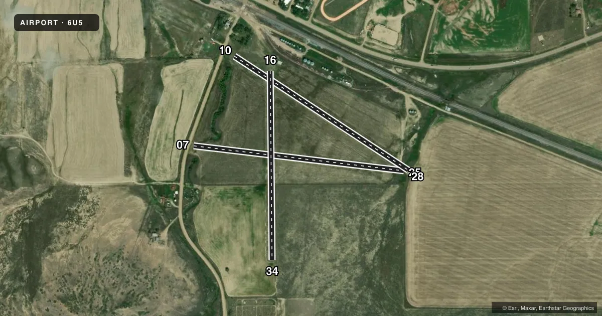
| 07/25Favored | 83° / 263° | 2,200 ft | TURF | Standard L |
| 10/28 | 109° / 289° | 2,160 ft | TURF | Standard L |
| 16/34 | 165° / 345° | 1,960 ft | TURF | Standard L |
Runway end performance
| End | TORA | TODA | ASDA | LDA | VGSI | Approach lights | Obstruction |
|---|---|---|---|---|---|---|---|
| 07 | — | — | — | — | — | — | 17', road, 36' from thr, 0' R of cntrln, slope 2 |
| 10 | — | — | — | — | — | — | 23', road, 487' from thr, 0' R of cntrln, slope 21 |
| 16 | — | — | — | — | — | — | 25', pole, 152' from thr, 20' R of cntrln, slope 6 |
| 34 | — | — | — | — | — | — | 49', tree, 429' from thr, 45' R of cntrln, slope 8 |
Declared distances in feet. TORA = takeoff run available, TODA = takeoff distance, ASDA = accelerate-stop, LDA = landing distance.
Airport sketch
Runways drawn to scale from FAA survey coordinates, rendered over satellite imagery. Not for navigation.
Approaches & charts
Services on the field
Fuel grades, oxygen, maintenance, ramp storage and lighting — as declared to the FAA by the airport operator.
Fuel & services
- Fuel
- Not available
- Oxygen (bottled)
- Not available
- Oxygen (bulk)
- Not available
- Airframe repair
- Not available
- Power plant repair
- Not available
Ramp & ground
- Transient storage
- Tie-down
- Landing fee
- No fee published
- Wind indicator
- Yes
- Segmented circle
- No
Fuel & FBOs
Cheapest 100LL and Jet A on the field and nearby. Always confirm with the FBO before taxi.
Airport notes
Surface conditions, obstructions, local procedures, lighting outages and other notes published with each FAA cycle.
General notes
- RYS SOFT WHEN WET.
- HAY BALES & FARM EQUIPMENT ADJACENT TO RY.
- FOR CD CTC SALT LAKE ARTCC AT 801-320-2568.
Runway surface & condition
- 16/34RY 16/34 MKD WITH WHITE CONES FULL LENGTH OF RY.
Approach & departure obstructions
- 344 FT TALL FENCE 10 FT FM RWY END.
- 0707/25 MKD WITH WHITE CONES FULL LENGTH OF RY.
- 1010/28 MKD WITH WHITE CONES FULL LENGTH OF RY.
- 16RWY 16 PLINE PR MARKED WITH 1 GLOBE.
VFR map & nearby airports
VFR sectional. Tap any ICAO chip to open that airport.
Key facts · 6U5
Answer card- ICAO
- 6U5
- Name
- HINSDALE
- Location
- HINSDALE, MONTANA
- Elevation
- 2,220 ft MSL
- Traffic pattern altitude
- 3,220 ft MSL (1,000 AGL)
- Control tower
- Non-towered (use CTAF)
- Total runways
- 3
- Longest runway
- 07/25 · 2,200 ft
- Published ILS approaches
- 0
- Published frequencies
- 1
- Magnetic variation
- 14°
- Current flight rules
- VFR
- Current wind
- 080° at 10 kt
- Favored runway now
- RWY 07
Hinsdale Airport (6U5) sits in Hinsdale, Montana at 2,220 ft MSL. It has three turf runways. The longest is 2,200 ft on runway 07/25. There is no control tower. CTAF is 122.9. No ILS approaches are published here.
Pattern altitude is not published. Use 1,000 ft AGL for light piston operations unless the current Chart Supplement says otherwise. That puts the normal pattern about 3,220 ft MSL based on the field elevation. The field is rural and the published remarks matter. Hay bales and farm equipment are near the runway. The turf can be soft when wet. Runway 10/28 and runway 07/25 are marked with white cones along the full length. Runway 16 has a marked power line. Runway 34 has a 4-foot fence 10 feet from the runway end.
There are no on-field FBOs listed. Plan self-sufficiency. For clearance delivery, contact Salt Lake ARTCC at 801-320-2568. With three short turf strips, this is a place to brief the surface condition, obstacle picture and your go-around plan before you turn final.