METAR & TAF KOLF
Current METAR
Observed 16:53Z
KOLF 271653Z AUTO 07011KT 10SM CLR 28/13 A2990 RMK AO2 SLP112 T02830133
- Wind
- 070° @ 11 kt
- Visibility
- 10 SM
- Temp / Dew
- 28°C / 13°C
- Altimeter
- 29.90 inHg
- Clouds
- CLR
- Density alt
- 4,051 ft
- Ceiling
- Unlimited
- Rules
- VFR
Airport info & contacts
Manager on record, flight service, ARTCC, attendance schedule and pattern altitude — published by the FAA and refreshed every 28 days.
Location
- From city
- 3 NM NE
- VFR sectional
- BILLINGS
- Pattern altitude
- 800 ft AGL · 2,789 ft MSL
- ARTCC
- ZLC · SALT LAKE CITY
- NOTAM facility
- OLF (NOTAM-D)
Airport manager
- Name
- ED BACH
- Phone
- (406) 650-8305
- Address
- WOLF POINT AIRPORT, 201 4TH AVE SOUTH, WOLF POINT MT 59201
Flight service · Hours
- FSS GTF
- GREAT FALLS1-800-WX-BRIEF
- Attendance
- MON-FRI · 0600-1930
Frequencies
Tap any row to copy the frequency to your clipboard.
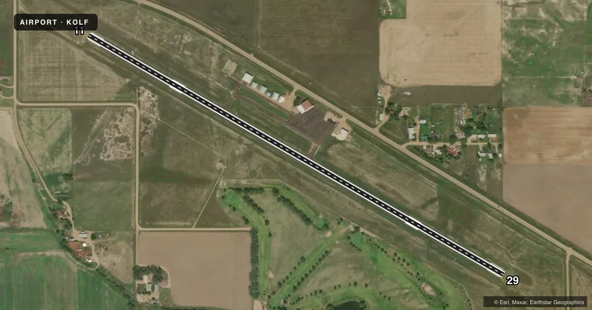
Runways & pattern
Full pagePattern entry · RWY 11
LEFT TRAFFICRunway end performance
| End | TORA | TODA | ASDA | LDA | VGSI | Approach lights | Obstruction |
|---|---|---|---|---|---|---|---|
| 11 | — | — | — | — | PAPI 2-box left(3°) | — | — |
| 29 | — | — | — | — | PAPI 2-box left(3°) | — | — |
Declared distances in feet. TORA = takeoff run available, TODA = takeoff distance, ASDA = accelerate-stop, LDA = landing distance.
Airport sketch
Runways drawn to scale from FAA survey coordinates, rendered over satellite imagery. Not for navigation.
Approaches & charts
Services on the field
Fuel grades, oxygen, maintenance, ramp storage and lighting — as declared to the FAA by the airport operator.
Fuel & services
- Fuel
- 100LL
- Oxygen (bottled)
- Not available
- Oxygen (bulk)
- Not available
- Airframe repair
- Not available
- Power plant repair
- Not available
- Other services
- AFRT,AGRI,AMB
Ramp & ground
- Transient storage
- Tie-down
- Hangar
- Landing fee
- No fee published
- Customs
- Not available
- Lighting schedule
- SEE RMK
- Beacon schedule
- SS-SR
- Beacon
- White / Green (civil land)(WG)
- Wind indicator
- Lighted
- Segmented circle
- Yes
Fuel & FBOs
Cheapest 100LL and Jet A on the field and nearby. Always confirm with the FBO before taxi.
Airport notes
Surface conditions, obstructions, local procedures, lighting outages and other notes published with each FAA cycle.
General notes
- WILDLIFE HAZ; WATERFOWL IN VCNTY.
- FOR CD IF UNA TO CTC ON FSS FREQ, CTC SALT LAKE ARTCC AT 801-320-2568.
Lighting notes
- ACTVT REIL RWY 11 & 29; PAPI RWY 11 & 29; MIRL RWY 11/29 - CTAF.
Fuel notes
- 100LL24 HR SELF SVC CREDIT CARD FUEL FAC. JET A FUEL NOT AVBL.
Other notes
- 1AIRFIELD SFC CONDS NOT MONTRD 2200-0500.
- 1FOR SVC AFT NML BUS HRS CALL AMGR 406-688-8308 OR 406-650-8305.
- MANAGERALTN MGR TOM ROMO WITH SAME CTC INFO AS ED BACH.
VFR map & nearby airports
VFR sectional. Tap any ICAO chip to open that airport.
Key facts · KOLF
Answer card- ICAO
- KOLF
- Name
- L M CLAYTON
- Location
- WOLF POINT, MONTANA
- Elevation
- 1,988.5 ft MSL
- Traffic pattern altitude
- 2,788.5 ft MSL (800 AGL)
- Control tower
- Non-towered (use CTAF)
- Total runways
- 1
- Longest runway
- 11/29 · 5,091 ft
- Published ILS approaches
- 0
- Published frequencies
- 2
- Magnetic variation
- 9°
- Current flight rules
- VFR
- Current wind
- 070° at 11 kt
- Favored runway now
- RWY 11
L M Clayton Airport sits in Wolf Point, Montana. Field elevation is 1,988.5 ft MSL. The airport has one runway, 11/29, which is 5,091 ft long with an asphalt surface. There is no control tower. CTAF and UNICOM are both 122.8.
No ILS approaches are published here. Pattern altitude is 800 ft AGL, which is 2,788.5 ft MSL. Runway end identifier lights are active on 11 and 29. PAPI is installed on both ends. Medium intensity runway lights are on runway 11/29 and are controlled by CTAF.
L.M. Clayton Airport is the on-field FBO. It carries 100LL. Jet A is not available. A 24-hour self-service credit card fuel facility is available for 100LL. For after-hours service, call the airport manager before you go. Published remarks also note wildlife hazard from waterfowl in the area. Airfield surface conditions are not monitored from 2200 to 0500, so plan accordingly if you are arriving late. If you need clearance delivery and cannot reach flight service, contact Salt Lake ARTCC. This is the kind of field where a quick radio check and a look at the current Chart Supplement are smart before departure.